Download
1 / 20
200 likes | 332 Vues
GOES-R Proving Ground OCONUS Meeting. Update on Product Implementation and Challenges Eric Lau NWS Pacific Region June 2013. Progress since the last OCONUS Meeting – Honolulu 2010. LX Band antenna installed at the Honolulu Community College with NPP data flowing to HFO and PRH.

E N D
GOES-R Proving Ground OCONUS Meeting Update on Product Implementation and Challenges Eric Lau NWS Pacific Region June 2013
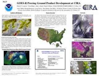
Progress since the last OCONUS Meeting – Honolulu 2010 • LX Band antenna installed at the Honolulu Community College with NPP data flowing to HFO and PRH. • MIMIC TPW implemented at HFO from LDM at UW CIMSS • Cloud Top Cooling (CTC) implemented at HFO from LDM at UW CIMSS. • Quantitative Precipitation Estimate (QPE) and Sea Surface Temperature (SST) implemented at HFO from LDM at NASA SPoRT. • Orographic Rainfall Index (ORI) implemented at HFO from LDM at CIRA. • Jordan Gerth developed World Wide Lightning Location Network (WWLLN) plugin for AWIPS II. • GOES-R Visiting Scientist Program underway for Pacific Region.
Island of Oahu – NWS and Partners JTWC Ford Island HCC UH, WFO Honolulu/CPHC PTWC NWS PRH Waikiki
World Wide Lightning Location Network (WWLLN) AWIPS II Plugin
Future Products on deck • GOES Sounder DPI over Hawaii expected on the SBN in August 2013. • TIGI16 - Lifted Index • TIGI17 - Precipitable Water • TIGI18 - Surface Skin Temperature • TIGI27 - Cloud Top Height • TIGI28 - Cloud Amount • MODIS imagery and products from the HCC antenna. • More NASA SPoRT products, i.e. MODIS, MODIS-VIIRS Hybrids, RGB • UH Pseudo-Reflectivity • GLD360 Lightning Density • Tropopause Folding/Turbulence Products
Pacific Region Challenges • Equipment, bandwidth, travel- • Geography limits communication circuits and infrastructure. • Working with people over many time zones. • Travel to remote destinations. i.e., Guam and American Samoa. • Limited resources for operations maintenance and configuration. • AWIPS I and II support- • AWIPS I products converted to AWIPS II compatible products. • AWIPS Configuration and Localization within the region. • TPW mapping issues. • Recently broken RegionalSat plug-in prevents viewing external satellite data like VIIRS. • Training for these great products…going forward- • Multiple people with multiple roles in maintaining a GOES-R presence. • GOES-R Visiting Scientist Program will focus training on their expertise. • Mark DeMaria and Kathy Strabala in Hawaii from July 9-11.
Mahalo and Aloha! Questions: Bill Ward – bill.ward@noaa.gov Eric Lau – eric.lau@noaa.gov