Download
1 / 23
230 likes | 318 Vues
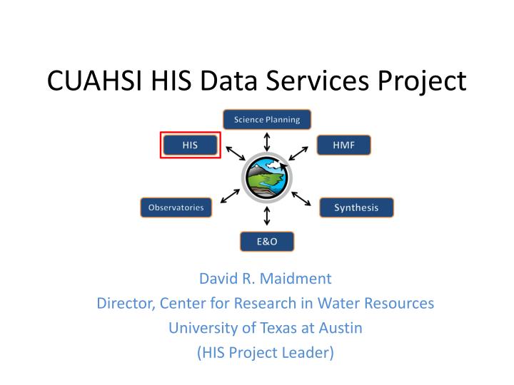
CUAHSI HIS Data Services Project. David R. Maidment Director, Center for Research in Water Resources University of Texas at Austin (HIS Project Leader). CUAHSI HIS Development. 2000. CUAHSI Regional Meetings. HIS Committee formed. 2002. 2006. Snowbird meeting & HIS White Paper.

E N D
CUAHSI HIS Data Services Project David R. Maidment Director, Center for Research in Water Resources University of Texas at Austin (HIS Project Leader)
CUAHSI HIS Development 2000 CUAHSI Regional Meetings HIS Committee formed 2002 2006 Snowbird meeting & HIS White Paper NSF Proposal Development 2004 HIS Pilot Project 2008 HIS Development Project http://www.cuahsi.org/publications/cuahsi_tech_rpt_2.pdf
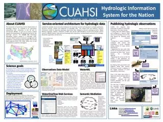
CUAHSI Hydrologic Information System Models Databases Analysis Goal: Enhance hydrologic science by facilitating user access to more and better data for testing hypotheses and analyzing processes • Advancement of water science is critically dependent on integration of water information • It is as important to represent hydrologic environments precisely with data as it is to represent hydrologic processes with equations Water quantity and quality Rainfall & Snow Soil water Meteorology Remote sensing
Definition The CUAHSI Hydrologic Information System (HIS) is a geographically distributed network of data sources and functions that are integrated using web services oriented architecture so that they operate as a connected whole.
Services Oriented Architecture (from Wikipedia) • Service-oriented Architecture (SOA) is an architectural design pattern that concerns itself with defining loosely-coupled relationships between producers and consumers. • A major focus of Web services is to make functional building blocks accessible over standard Internet protocols that are independent from platforms and programming languages. • The Web Services Description Language (WSDL, pronounced 'wiz-dəl') is an XML-based language that provides a model for describing Web services. Defined by the World Wide Web Consortium (W3C)
Locations Variable Codes Date Ranges WaterML and WaterOneFlow STORET Data GetSiteInfo GetVariableInfo GetValues Data NAM NWIS WaterML Data WaterOneFlow Web Service Data Repositories Client EXTRACT TRANSFORM LOAD WaterML is an XML language for communicating water data WaterOneFlow is a set of web services based on WaterML
Return data in WaterML Set of query functions WaterOneFlow http://river.sdsc.edu/wateroneflow/ Open Geospatial Consortium, Inc. (2007), CUAHSI WaterML, OGC Discussion Paper, OGC 07-041r1, Version 0.3.0, Zaslavsky, I., D. Valentine, and T. Whiteaker Editors, http://www.opengeospatial.org/standards/dp,
Web pages Web services We are at a tipping point …. Internet Internet Computer Person Computer Computer People interact with a remote information server Networks of information servers provide services to one another
Water web pages Water web services Information communication Water Markup Language (WaterML) HyperText Markup Language (HTML)
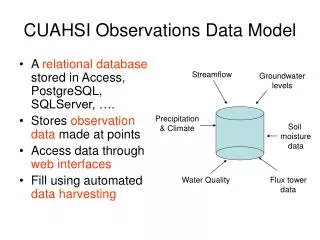
Point Observations Information Model http://www.cuahsi.org/his/webservices.html Utah State Univ Data Source GetSites Little Bear River Network GetSiteInfo Little Bear River at Mendon Rd Sites GetVariables GetVariableInfo Dissolved Oxygen Variables GetValues 9.78 mg/L, 1 October 2007, 6PM Values {Value, Time, Qualifier, Offset} • A data source operates an observation network • A network is a set of observation sites • A site is a point location where one or more variables are measured • A variable is a property describing the flow or quality of water • A value is an observation of a variable at a particular time • A qualifier is a symbol that provides additional information about the value • An offset allows specification of measurements at various depths in water
David Tarboton and Jeff Horsburgh, Utah State University CUAHSI Observations Data Model http://www.cuahsi.org/his/odm.html
WATERS Network Information System National Hydrologic Information Server San Diego Supercomputer Center • 11 WATERS Network test bed projects • 17 ODM databases (some test beds have more than one ODM) • Data from 1643 sites, of these, 167 sites are operated by WATERS • 28 million data values describing 202 variables
Map for the US Build a common window on water data using web services Observation Stations Ameriflux Towers (NASA & DOE) NOAA Automated Surface Observing System USGS National Water Information System NOAA Climate Reference Network
Observations Catalog Specifies what variables are measured at each site, over what time interval, and how many observations of each variable are available
Syntactic mediation Heterogeneity of format Use WaterML to get data into the same format Semantic mediation Heterogeneity of meaning Each water data source uses its own vocabulary Match these up with a common controlled vocabulary Make standard scientific data queries and have these automatically translated into specific queries on each data source Data Heterogeneity
request return return request NAWQA request return return request NAM-12 request return NWIS request return request return return request NARR Objective • Search multiple heterogeneous data sources simultaneously regardless of semantic or structural differences between them What we are doing now ….. Michael Piasecki Drexel University
NAWQA NWIS NARR HODM Semantic Mediator What we would like to do ….. GetValues GetValues GetValues GetValues generic request GetValues GetValues Michael Piasecki Drexel University GetValues GetValues
Hydroseekhttp://www.hydroseek.org Bora Beran, Drexel Supports search by location and type of data across multiple observation networks including NWIS and Storet
HydroTagger Ontology: A hierarchy of concepts Each Variable in your data is connected to a corresponding Concept
Critical Zone Observatories(Slide from Suzanne Anderson, Univ. of Colorado)
Digital Watersheds A digital watershed is a structured collection of digital representations of inter-related hydrologic objects and measurements that facilitates integrated modeling and analysis.
CUAHSI Hydrologic Information System Models Databases Analysis Goal: Enhance hydrologic science by facilitating user access to more and better data for testing hypotheses and analyzing processes • Advancement of water science is critically dependent on integration of water information • It is as important to represent hydrologic environments precisely with data as it is to represent hydrologic processes with equations Water quantity and quality Rainfall & Snow Soil water Meteorology Remote sensing
How has CUAHSI Helped? • A management structure for the academic hydrologic science community to work together • Formed the original HIS Committee – got the effort started • A mechanism by which we can serve and support our hydrologic science colleagues