Turkey Earthquake Risk Model
420 likes | 1.04k Vues
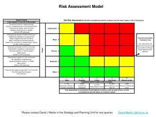
Turkey Earthquake Risk Model. Financing the Risks of Natural Disasters World Bank Washington, DC , June 2-3, 2003 Dennis E. Kuzak Senior Vice President, EQECAT, Inc. Overall Model Components. Turkish Census and building stock data, plus TCIP information.

Turkey Earthquake Risk Model
E N D
Presentation Transcript
Turkey Earthquake Risk Model Financing the Risks of Natural Disasters World Bank Washington, DC , June 2-3, 2003 Dennis E. Kuzak Senior Vice President, EQECAT, Inc
Overall Model Components Turkish Census and building stock data, plus TCIP information Portfolio of Insured TCIP Exposures Professor Erdik, USGS Research Papers, historical catalogs Seismotectonic Model - fault/source locations, magnitudes, frequencies Attenuation Functions,Local Soil Conditions Seismic Hazard - Ground Shaking Historical Building Performance, Engineering Analysis, Turkish construction practices Vulnerability Policy Deductibles, Limits Damage and Financial Loss
Seismic Hazard Modeling Methodology The location, size, and frequency of rare catastrophic earthquakes and their associated ground shaking are modeled using a Probabilistic Seismic Hazard Analysis (PSHA), which is composed of the following elements: • Source zonation model (location) • Recurrence model (size and frequency) • Ground motion model (ground shaking) • Hazard curve (ground shaking vs. probability) • Soil model (ground shaking amplification)
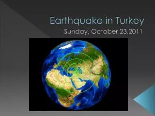
Earthquakes in Turkey, 1904-1992 Legend: M 5.0-5.9 (purple); M 6.0-6.9 (blue); M 7.0+ (red)
Earthquake Sources of Turkey White Source: Erdik et al. (1999), “Assessment of earthquake hazard in Turkey and neighboring regions,” Annali di Geofisica, Vol. 42, pp. 1125-1138.
Seismic Hazard Map of Turkey PGA (g) with a 10% Probability of Exceedance in 50 Years (475-year Return Period) on soft rock Black Sea Istanbul Ankara Sea Mediterranean Source: Erdik et al. (1999), “Assessment of earthquake hazard in Turkey and neighboring regions,” Annali di Geofisica, Vol. 42, pp. 1125-1138. White
EQECAT Source Zonation Model • Basic area-source model from Erdik et al. (1999) • Large characteristic earthquakes (M 6.5): • North Anatolian Fault (NAF) • Northern NAF (NNAF; Marmara Sea) • Southern NAF (SNAF; south of Marmara Sea) • Distributed faulting on NNAF and SNAF • Smaller earthquakes included as NAF, NNAF and SNAF background seismicity zones
Marmara Sea Region NNAF NAF SNAF
North Anatolian Fault System (NAF) • Potentially the largest contributor to seismic hazard in Istanbul and northwestern Turkey • Ruptures in a sequence of large earthquakes • Previously known rupture sequences occurred in 967-1050 and 1254-1784 • Latest sequence began in 1939 and is still in progress • Latest events in current sequence are the 1999M 7.4 Izmit and M 7.2 Duzce earthquakes • Next event in sequence is likely to be in Marmara Sea (Yalova and/or Prince’s Islands Faults?)
Rupture History of the NAF to 1992 Note: Mean repeat time is now estimated to be 225 years east of NNAF/SNAF split and 280 years west of this split (Stein, personal comm., 2000; Parsons et al., 2000)
EQECAT Recurrence Model • Area and background sources • Fault sources: • North Anatolian Fault (NAF) • Northern NAF (NNAF; Marmara Sea) • Southern NAF (SNAF; south of Marmara Sea)
Recurrence: Area and Background Sources • Earthquake catalog from regional sources: • All magnitudes converted to moment magnitude • Foreshocks, aftershocks and swarms removed • Corrected for incompleteness • Exponential (Gutenberg-Richter) recurrence law • Maximum magnitude from seismicity/tectonics
Recurrence: Fault Sources • Characteristic earthquake recurrence law • Recurrence rates from previous historic events • Magnitudes on NAF from last historic event • Magnitudes on NNAF from length/historic events • Magnitudes on SNAF from largest historic event • Time-dependent probability on NAF and NNAF
EQECAT Time-Dependent Model Definition of Time-Dependent Probability Time-dependent probability is the conditional probability that an earthquake will occur on a fault within some specified period of time in the future (i.e., 2000 to 2030), given that a similar earthquake has occurred on this fault at some known time in the past
Causes of Time-Dependent Behavior • Secular stress increase due to long-term strain accumulation • Permanent stress increase or decrease due to stress interaction from an earthquake on a nearby fault • Transient stress increase or decrease due to stress interaction from an earthquake on a nearby fault (decays with time)
Time-Dependence from Secular StressLognormal Probability Model PARAMETERS Te = Elapsed TimeT = Exposure Period A B Conditional Probability = A/(A + B) Last Earthquake Note: We use recurrence intervals of 225 years east of NNAF/SNAF split and 280 years west of split; exposure period of 1 year; elapsed time from last historic event
Time-Dependence from Secular StrainSensitivity to Total Variability Note: We use = 0.5
Time-Dependence from Fault InteractionTransient Stress for NAF Source: Parsons et al. (2000)
Time-Dependence from Fault InteractionProgressive Effect of1939-1992 Earthquake Sequence Source: Stein et al. (1997)
Time-Dependence from Fault InteractionEffect of 1999 Izmit Earthquake Source: Parsons et al. (2000)
Time-Dependence from All EffectsFaults within 50 km of Istanbul Source: Parsons et al. (2000); Our results give 50% smaller probability
Time-Dependence from All EffectsIstanbul Earthquake Probabilities of M 7 for Faults within 50 km of Istanbul Beginning in May 2000 (Interaction includes Secular and Interaction Stress Effects) Note: 30-year time-averaged (Poisson) probability is 20 10% Source: Parsons et al. (2000); Our results give 50% smaller 1-year combined probabilities
EQECAT Ground Motion Model • Four attenuation relationships for shallow crustal earthquakes: • Abrahamson and Silva (1997) • Boore et al. (1997) • Campbell (1997) • Sadigh et al. (1997) • One attenuation relationship for subduction earthquakes: • Youngs et al. (1997) • 1999 Izmit earthquake validation
PGA Estimate for 1999 Izmit Event Note: PGA in g; Values are consistent with limited strong-motion recordings
EQECAT Soil Model • NEHRP soil classifications (A-E) were derived from a 1:500,000-scale geologic map of Turkey • Correlation with geology was based on extensive studies relating shear-wave velocity and geologic units in California • PGA amplification factors were based on empirical and theoretical studies relating shear-wave velocity and amplification
EQECAT Hazard Results • Seismic hazard curves: • Istanbul (Bakirkoy) • Izmit • Ankara • Seismic hazard maps: • All of Turkey • Marmara Sea Region
Seismic Hazard Curves • Lowest hazard in Ankara, located in more stable central region of Turkey • Hazard in Izmit is approximately the same as that in Istanbul (Bakirkoy) because: • Time-dependent probability effects have increased hazard in Istanbul • Time-dependent probability effects have decreased hazard in Izmit Soft Rock
PGA (g) 0.05 - 0.10 0.10 - 0.15 0.15 - 0.20 0.20 - 0.25 0.25 - 0.30 0.30 - 0.35 0.35 - 0.40 0.40 - 0.45 0.45 - 0.50 0.50 - 0.55 0.55 - 0.60 0.60 - 0.65 0.65 - 0.70 0.70 - 0.75 0.75 - 0.80 0.80 - 0.85 0.85 - 0.90 Seismic Hazard Map for Turkey PGA with 10% Probability of Exceedance in 50 Years (475-year Return Period) Soft Rock
PGA (g) 0.05 - 0.10 0.10 - 0.15 0.15 - 0.20 0.20 - 0.25 0.25 - 0.30 0.30 - 0.35 0.35 - 0.40 0.40 - 0.45 0.45 - 0.50 0.50 - 0.55 0.55 - 0.60 0.60 - 0.65 0.65 - 0.70 0.70 - 0.75 0.75 - 0.80 0.80 - 0.85 0.85 - 0.90 Seismic Hazard Map for Marmara Sea PGA with 10% Probability of Exceedance in 50 Years (475-year Return Period) Soft Rock
Building Vulnerability • Good building codes- poor construction practices • Non ductile concrete frames, soft story • Limited/No claims data for residential multi-family • EQECAT approach- use aggregate residential damage data from Izmit, select damage curve consistent with Izmit data.
Summary • Turkish Model incorporates current research on time-dependent studies of North Anatolian Fault • Raises hazard in Istanbul • Lowers hazard east of Izmit epicenter • Recognizes uncertainty in NAF location in the Marmara Sea • Incorporates poor building practices into vulnerability assumptions • Fully probabilistic damage and loss model consistent with other EQECAT earthquake models for the US, Japan, Taiwan, etc.
TCIP RISK ANALYSIS RESULTS Portfolio exposures estimated as of 31-10-2002 Estimated Annual Damage = .138% (1.38 per mill)