Download
1 / 13
130 likes | 468 Vues
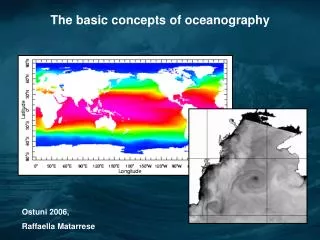
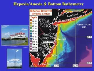
12 m 15 m 20 m 25 m 30 m 35 m. Warsh – NOAA 1989. 40 m 50 m 100 m 500 m. 1000m 2500m. Hypoxia/Anoxia & Bottom Bathymetry. New Jersey Shelf Observing System (NJ-SOS). 300km x 300km Began in 2001. Satellites, RADAR, Gliders. ICES. PICES. LINKS. GOOS. POGO. CoML. 6 Field

E N D
12 m 15 m 20 m 25 m 30 m 35 m Warsh – NOAA 1989 40 m 50 m 100 m 500 m 1000m 2500m Hypoxia/Anoxia & Bottom Bathymetry
New Jersey Shelf Observing System (NJ-SOS) 300km x 300km Began in 2001 Satellites, RADAR, Gliders
ICES PICES LINKS GOOS POGO CoML 6 Field Projects HMAP OBIS GLOBEC SCOR WG FMAP IABO UNEP WCMC IOC WESTPAC GBIF
256,000 Codes 25g Animals Pacific Ocean Salmon Tagging (POST)
TOPP Tracking of Pacific Predators reveals locations of the ecosystems they feed on
MAR-ECO G.O. Sars Norway Vecchione et al. Science, 2001 Mid-Atlantic Ridge Ecosystem Properties
ChEss Biogeographic Patterns of Chemosynthetic Ecosystems
The Census of Marine Life is: • a research program that will examine changes in the diversity, distribution and abundance of marine organisms in time and space • an international program that will involve experts in a variety of biological fields from around the globe • an emerging program that will identify key questions and support observations and research over the next 5-10 years
Major international research program • Federation of heterogeneous databases • Interoperable through the OBIS Portal: • data requests & searches • network tools & models • research & education center
Gulf of Maine Area Pilot Integrated Data Project Benthic/Pelagic Coupling GoMOOS Physical
Recommendations • Support for IOOS infrastructure and operational needs of regionally-defined observing systems • Technology development on the full range of platforms—ships, buoys, AUVs, floats, gliders, bottom observatories—emphasize biology • Close linkage of IOOS with strong science programs (e.g. CoML/OBIS, CoOP, GLOBEC, GODAE, OE, NERRS, NURP, and USGS) • Operational oceanography education programs