SOUTH ASIA
SOUTH ASIA. Geography 200 Dr. Stavros Constantinou. INDIA. The name India comes from the Sanskrit word sindhu which was used to identify the ancient civilization in the Indus Valley. This word became sinthos in Greek descriptions of the area and then sindus in Latin.

SOUTH ASIA
E N D
Presentation Transcript
SOUTH ASIA Geography 200 Dr. Stavros Constantinou
INDIA • The name India comes from the Sanskrit word sindhuwhich was used to identify the ancient civilization in the Indus Valley. • This word became sinthos in Greek descriptions of the area and then sindus in Latin. • Corrupted to indus (means river), it was applied to what constitutes today's Pakistan. • Subsequently it was again modified to India to refer generally to the land of river basins and clusters of peoples from the Indus River in the west to the Brahmaputra River in the east.
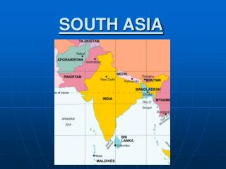
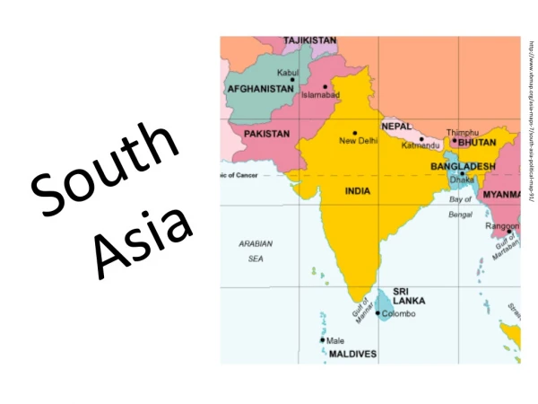
INDIA: LOCATION AND SIZE • India is located between 8° N and 37° N. The Tropic of Cancer passes through northern India. • Such cities as Ahmadabad, Kolkata (Calcutta), Karachi, Bhopal and Dhaka are located close to the tropic. • India, the world's seventh largest country, has an area of 3,286,170 sq km (1,269,340 sq mi) which represents 2.2 percent of the total land area of the planet (57,900,000 sq mi).
INDIA: LANDFORMS • There are three main landform regions in South Asia: Alpine chains, sedimentary covers, and Gondwana Shield. • Alpine system: The Himalayas form a major barrier to the movements of air masses north and south and exceed 6,096 m (20,000 ft) in several locations. • Mount Everest (Nepal: Sagarmatha; Tibetan: Chomolungma) is the world’s highest mountain at 8,848 m (29,035 ft). • The climate ranges from tropical lowlands to Arctic conditions in the high altitudes of Mount Everest and other peaks. • The Karakoram Pass provides access from north-central India through the Himalayan and Hindu Kush mountains. • The Khyber Pass in the west was used by invading groups. • Population in the Himalayas is limited except in the Vale of Kashmir and in Nepal (25,200,000 people). • Bhutan has 900,000 and Sikkim less than one million. Sikkim has been incorporated into India and is one of its provinces. • Rice and wheat are the dominant grain crops.
INDIA: LANDFORMS • Sedimentary covers: The riverine plains of the Indus, the Ganges (known as Ganga to Indians), and the Brahmaputra and the coastal plains of the Indian Peninsula form this region. • The North Indian Plain forms a belt of alluvial lowlands stretching from Pakistan’s Indus River on the west to the Brahmaputra on the east. • The Ganges River with its various tributaries is the major river of northern India. • This region of plains is from 320 to 500 km (200 to 300 mi) wide and it extends through Pakistan, India, and Bangladesh. • The climate varies from arid in Punjab to tropical around the Bay of Bengal. • Soils (inceptisols) are derived from alluvium and they are relatively fertile and generally level. In the arid areas, irrigation has created environmental problems through accumulation of salts (salinization).
INDIA: LANDFORMS • Gondwana Shield: This landform region extends southward from the southern borders of the Ganges drainage area and includes the lava covered Deccan Plateau. • This plateau is framed on the north by the Vindhyas and the Tapti and Godavari Rivers; on the west, the Western Ghats (Hills) lining the Malabar Coast; on the east, the Eastern Ghats paralleling the Coromandel Coast; at the southern margin are the Blue Mountains which exceed 2,600 m (8,800 ft). • The central portion of the Deccan Plateau has fertile soils (vertisols), derived from volcanic materials, primarily cultivated with cotton. • Elevations of the Deccan Plateau are approximately 305 to 450 m (1,000 to 1,500 ft). • The coastal areas have a humid tropical climate with abundant rain from the orographiceffect of the Ghats.
INDIA: CLIMATE • The monsoon(the seasonal reversal of wind systems) is the dominant climate force. • With few exceptions the climate of Monsoon Asia is tropical or sub-tropical. • Air flows from land to sea with dry conditions in winter and a sea-to-land movement in summer with humid conditions. • The causes of the monsoon are the shifting of the jet stream north and south of the Himalayas and the differential heating between land and water. • During the summer the jet stream moves north of the Himalayas allowing moist air to penetrate the continent from the oceans. • In winter, the jet stream is divided with one part south of the Himalayas. • The air movement effectively prevents moisture from the oceans from moving into the core area of India along the Ganges and dry conditions predominate. • Land heats quickly and loses the heat quickly while bodies of water heat up slowly and lose heat slowly.
INDIA: CLIMATIC REGIONS • Tropical rainforest (Am): Coromandel and Malabar coastal regions. Controls-latitude and orographic effect. • Humid subtropical (Cwa): Ganges Valley. • Tropical savanna (Aw): Western reaches of Vindhya Ranges to Ganges Delta. • Subtropical steppe (BSh): Deccan Plateau. Inadequate summer moisture. Rainshadow effect of Western Ghats. • Subtropical desert (BWh): Indus Valley and the Thar (Great Indian) Desert.
INDIA: VEGETATION The main vegetation regions of India are the following: • Broadleaf deciduous: Extensive area in northwestern India and Pakistan. Shrubs can grow to a maximum of one meter (three feet) singly or in groups. • Broadleaf deciduous: Same as above except trees grow to a minimum of one meter singly or in groups. It surrounds the area above. • Broadleaf deciduous ( terai): An extensive area from the Gangetic Plains to southern India. Terai Lowlands in Nepal. • Broadleaf evergreen: Malabar Coast, Coromandel Coast and Sri Lanka. • Semi-deciduous: broadleaf evergreen and broadleaf deciduous: They are found in an area inward from the Malabar Coast and the lower valley of the Ganges. • Broadleaf deciduous trees. Bihar and Orissa. Broadleaf evergreen, shrub form, minimum height one meter (3 feet).
INDIA: SOILS The main soil regions of India are the following: • Aridisols: Northwestern India and Pakistan. Salts may accumulate on or near the surface of these soils which are poor in organic matter. • Alfisols: Northern sections of the Gangetic plain and extending to Kathiawar Peninsula. They are also found in area south of 20 degrees N latitude and along the Coromandel Coast. • Inceptisols: They are found in the Gangetic plains and the Malabar Coast. They are immature and weakly developed soils. • Vertisols: An extensive area from north of Mumbai (Bombay) to the Ganges River. These soils are rich in clays and crack deeply during dry periods. • Ultisols: They are found in northeastern India (Bihar and Orissa).
INDIA: RESOURCES India has a rather poor resource base. The country does not lead the world in any of the important minerals or other sources of energy useful for industrialization and development. • India is the second largest producer of grains. The possibility for expanding production of grains remains very low, despite gains. Low productivity per person in the agricultural sector accentuate the problems of population, making it difficult to increase production. • India has the largest deposit of high-grade iron ore in the world. In Bihar state alone, a single range is estimated to hold nearly three billion tons of iron ore. Iron ore deposits are also important in the state of Karnataka. India produces 5.6 percent of the world's iron ore and has 6.6 percent of the world's reserves in iron ore.
INDIA: RESOURCES • India produces 3.8 percent of the world's coal. Coal and steel are produced in the Damodar Valley fields of northeastern India which account for more than 50 percent of coal production. Limited coking-coal deposits are found in Chota Nagpur. • India has discovered oil deposits in the Bay of Bengal which hold promise for further expansion. • India has a great hydroelectric potential, provided dams are constructed to exploit the rivers of the country. • India has important deposits of uranium; phosphates in the Thar Desert, and manganese (5.2 percent) in the central Deccan plateau and eastern Coromandel Coast. • India produces 2.5 percent of the world's bauxite, and it produces 5.2 percent of the world's chromite.
INDIA: POPULATION GEOGRAPHY • India had 1,068,600,000 people in 2003 (17% of the world total), the world's second largest country in population after China. • India has a rate of natural increase of 1.7% (compared to a 1.3% world rate) and a projected population of 1,363,000,000 by 2025. • At this rate, it is only a matter of time before India becomes the world's most populous country. • The largest clusters of the Indian population are found in the Gangetic plains in the north and the coastal areas of the country. These are the most fertile parts of India.
INDIA: POPULATION GEOGRAPHY • There was an increase of 19,100,000 people from 2002 to 2003. • From 2001 to 2002, the absolute population increase of 16,500,000. • In 2000, India had 1,002,100,000 people, while in 1920 the population of the country was 250,000,000. • The population of the country quadrupled in 80 years. • The Ganges-Brahmaputra and Indus River systems are crucial lifelines for hundreds of millions of people.
INDIA: POPULATION GEOGRAPHY • In India, population arithmetic density (in 2003) was 325 persons per sq km (842 persons per sq mi); physiological density (in 2000) was at 557 persons per square kilometer (1442 persons per square mile). • In neighboring Bangladesh the arithmetic density is approximately 2.5 times as high, 1,040 persons per sq km (2,639 persons per sq mi).
INDIA: POPULATION GEOGRAPHY • In 1952, the Indian government adopted family planning as a national policy. • By 1961, there were 4,165 family planning clinics. • As a part of the government campaign to limit the number of children, the government has put up billboards with the following slogan: "four is a family, five is a crowd." • In 1976, a national population policy was adopted including: • the increase of the age of marriage for females to 18 years and for males to 21, • tying financial grants from the federal government to the state governments to their performance in limiting births, • provision of sex education in schools, • expansion of compensation for voluntary sterilization, • and use of incentives by governments to encourage people to limit their family size. • In 1977, this policy was made voluntary following the collapse of the Indira Gandhi government. Only 8% of federal assistance was tied to performance on birth control by states.
INDIA: URBAN GEOGRAPHY • In 2003, India was one of the least urbanized of the large in population countries of the world, given that only 28 percent of the country's population resided in urban areas. • Although the proportion classified as urban is small, in absolute numbers India had 299,208,000 people residing in urban centers. • Mumbai (formerly Bombay), with 11,914,398 people, is the largest city of India in terms of population. Delhi ranks second with 9,817,439 followed by Kolkata (formerly Calcutta) with 4,580,544. • 11 Indian cities have populations in excess of one million inhabitants. • The largest metropolitan area populations of India are: • Mumbai 16,368,084 • Kolkata 13,216,546 • Delhi 12,791,458
INDIA: URBAN GEOGRAPHY • Indian urbanization is accelerating, and urban India is today growing more than twice as rapidly as the country's overall population. • Attendant problems include poor sanitation, street dwellers, and riots. • In 1984, riots between Hindu and Moslems in Mumbai left hundreds dead. • Reasons for migration to cities (internal migration): • Loosening of ties between poor peasants and their villages. • Widespread establishment of village men or "caste brothers" who encourage friends and relatives to move to the cities.
INDIA: URBAN GEOGRAPHY • The location of India's modern urban centers is a reflection of colonialism. • The British founded and developed Kolkata (Calcutta), Mumbai (Bombay), and Chennai (Madras) as regional trading centers and as coastal focal points for their colony's export and import traffic. • In Chennai (Madras), they built a fort in 1640. • In Mumbai (Bombay) in 1644, they fostered the growth of a port-city that was closest to Britain and Europe. Mumbai is located on the west coast of India • Kolkata (Calcutta) lies 130 kilometers (80 miles) from the east on the Hooghly River, and a myriad of Ganges River delta channels connect it to its hinterland. • Kolkata (Calcutta) lost a large part of its hinterland to Pakistan at the time of the partitioning of British India. This area is now a part of Bangladesh. • An 1812 rebellion forced the British to move the colonial capital from Kolkata (Calcutta) to the safer interior city of New Delhi, built adjacently to the old Mogul headquarters of Delhi.
INDIA: URBAN GEOGRAPHY • Population densities in urban centers are very high. • Kolkata (Calcutta) averages 13,900 persons per sq km (36,000 persons per sq mi) for its entire area of 1036 sq km (400 sq mi). • By comparison, New York City averages 1544 persons per sq km (4,000 persons per sq mi). • In Kolkata (Calcutta), an estimated 200,000 residents are known as street people and sleep under bridges, railway overpasses, in doorways or wherever they can find a spot. • Slightly better off are the residents of the bustees, hovels made of cardboard, burlap, or other scrap material. • An estimated 2,000,000 people live in bustees.
INDIA: URBAN GEOGRAPHY • Indian urbanization reveals several regional patterns: • The northern heartland, the west (wheat growing area) is more urbanized than the east (where rice forms the main staple crop). • In the west urbanization may be as much as 40%; in the east only about 10% of the population resides in urban centers. • India's larger cities (more than 100,000) are concentrated in three regions: (1) the northern plains from Punjab to the Ganges Delta (2) the Bombay-Ahmadabad area (3) the southern end of the peninsula, which includes Madras and Bangalore • Large cities(more than one million) outside these regions include centrally positioned Nagpur and Hyderabad (capital of Andhra Pradesh).
INDIA: CULTURAL GEOGRAPHY • India is indeed a Babel of languages. In 1947, the Indian subcontinent had 550 princely states, 900 separate dialects and 15 major languages. • The two major linguistic families are the Indo-European and the Dravidian. • Languages that are members of the Indo-European family are spoken in the central and northern parts of the country, and languages that belong to the Dravidian family are spoken in southern India. • Dravidian languages are spoken by about 25 percent of the Indian population. They include Telugu, Tamil, Kannada, and Malayalam. • Today India has fourteen official languages including Hindi and English (associate official). Hindi is the official and predominant language of India. • Hindi was one of the 14languages given national status by the Indian constitution, 10 in the north and 4 in the Dravidian south. • Before World War II, the British recognized 179 official languages and 544 dialects (total=723). • English would remain a lingua franca when Hindi could not serve as a medium of communication at government and administrative levels.
INDIA: CULTURAL GEOGRAPHY • Southern Asia Is marked by strong cultural regionalism. • Division is largely based on religious differences between Moslem dominated and Hindu dominated regions. • The Ganges River is the most important river of South Asia. It is the most sacred of all rivers to the Hindus, and provides water to a major urban area along its course, including Kolkata (Calcutta) in India and Dhaka in Bangladesh. • The Hindustan holy city of Varanasi is located on the Ganges.
INDIA: CULTURAL GEOGRAPHY • Religions: • Hinduism 81.3% • Muslim 12.0% • Sunni 9.0% • Shiite 3.0% • Christian 2.3% • Protestant 1.1% • Roman Catholic 1.0% • Sikh 1.9% • Buddhist 0.8% • Jain 0.4% • Zoroastrian 0.01% • Other 1.3%
INDIA: CULTURAL GEOGRAPHY • Hinduism: • This system of beliefs forms the cultural basis of the Indian society, which is highly stratified. • The caste system is an integral part of Hinduism. • A casteis a hereditary social group limited to persons of the same rank, occupation, etc., and having distinctive mores. • Dharma in Hinduism is the individual duty of each person. Dharma is related to the rigid social order of India (caste system), since the caste to which one is born in determines the duty that must be followed.
INDIA: CULTURAL GEOGRAPHY • Hinduism: • Four broad castes exist in Hindu Society: • Brahmans: are the teachers, religious leaders, and scholars. • Kshatriya: political leaders and warriors. • Vaisya: are engaged in trades or farming. • Sudra: are the lowest class and provide services to support the society.
INDIA: CULTURAL GEOGRAPHY • Hinduism: • Each of these four broad groups is broken down into subgroups whose relative status is dependent upon their extent of ritual purity (avoidance of contact with unclean objects). • Those dealing with death or decaying materials were in the lowest classes of the sudra. • At the very bottom of the order are the untouchables (harijans), so called, because in the past (and among many Indians today) it is believed that they would contaminate others’ ritual purity if there was any personal contact between them. • Untouchables lived in separate communities, had separate wells for water, and in the 19th century, were prohibited from using roads used by other castes
INDIA: CULTURAL GEOGRAPHY • Hinduism: • Aspect of life related to the cycle of life, death, and rebirth, or reincarnation. • For the Hindu, life is not simply a progression from birth until death, but a progression in a circular fashion until freedom is obtained from the cycle. • Freedom from continued reincarnation can be obtained through nirvana, which consists of obtaining spiritual unification with the cosmic forces, and being liberated from the human processes of death and birth.
INDIA: CULTURAL GEOGRAPHY • Associated with nirvana and reincarnation is the concept of karma, or law of the deed. • Karma specifies that for each good act there will be a reward and for each evil act there will be a punishment. • An individual's status in the caste system reflects actions in the previous incarnations. • It is impossible to move upward in the caste system through education or acquisition of wealth or social change, since a specific caste is a result of previous actions. • Suttee is a Hindu practice whereby a widow immolated herself on the funeral pyre of her husband.
INDIA: HISTORICAL GEOGRAPHY • Aryan invaders from Western Asia conquered the early Indus Valley civilization around 3500 BC. • They pushed settlement frontiers east into the Gangetic Plain and south into the center of the peninsula. • India’s culture developed from this beginning, including the Hindu religion and the caste system – rigid social stratification. • Buddhism was dominant during the Mauryan Empire (3rd century BC to 2nd century AD). • Buddhism soon declined in South Asia, remaining strong only in Sri Lanka, where it still prevails. • Buddhism today is centered mainly in East and Southeast Asia.
INDIA: HISTORICAL GEOGRAPHY • Arabs invaded northwestern India shortly after 700 AD, bringing with them Islam. • After the 10th century, Islam was a strong influence in India, driving out Buddhism, but not Hinduism, which remained dominant in India’s Ganges core area and southern India. • Muslims remain a sizeable minority (slightly less than 15%) in India, and form overwhelming majorities in Pakistan and Bangladesh. • The Mogul dynasty was founded in 1526. • Taxation of land was based on granting rights to tax to a local authority. • Under the Mogul system the individual peasant retained ownership of the land. • The Mogul dynasty collapsed in 1707, leaving a kingdom without a ruler and presenting the opportunity for European domination.
INDIA: HISTORICAL GEOGRAPHY • European contacts in south Asia were made by the Portuguese, Dutch, French, and British. • All European colonial powers established trading posts for spices and fabrics, but eventually Britain emerged as the dominant colonial power in South Asia. • The period of British colonial dominance in India can be divided into two parts : • Period I (1757-1857). Domination of India by the British East India Company. • Period II (1858-1947). India as a British Crown Colony. • In 1600, Queen Elizabeth I granted exclusive rights to the spice trade of Asia to the BritishEastIndiaCompany,under which India began to come under British control.
INDIA: HISTORICAL GEOGRAPHY • By 1858, nearly 2/3 of the subcontinent was ruled directly by the company; the remaining inaccessible areas were controlled by more than 500 princely states. • Rebellion of Indian troops against the British in 1857 culminated in a decision to strip the British East India Company of its monopoly and proclaim the subcontinent a crown colony (1858). • Britain exercised outright political control over India from 1857 to 1947. • The British introduced many innovations to India, but forced the colonial economy of India to become a raw material producer subservient to the English master.
INDIA: HISTORICAL GEOGRAPHY • The impact of colonialism on India can be summarized as follows: • Pros: • Creation of a civil service patterned after the British model which became part of the new independent governments that were set up upon the departure of the British. • Development of an extensive railroad and road transportation system. Although the development of this system had as its objective the movement of troops to troubled spots, India inherited a well planned and developed system. • Improvements in sanitation and simple hygienic practices that led to the beginnings of rapid population increases.
INDIA: HISTORICAL GEOGRAPHY Cons: • The British East India Company granted the village representatives deeds to the lands from which they had collected taxes under the Moguls. Thus, the village representatives became landlords charging cash rent. Property ultimately ended in the hands of urban moneylenders as peasants borrowed at exorbitant interest rates to pay taxes, and a large rural landless class emerged. • Peasants produced crops demanded by the British East India Company including coffee, tea, sugar, spices, cotton, indigo, and jute. As British influence in Asia spread to China, opium also became an important crop, as it could be resold or traded in China for additional high-value spices. Because crops encouraged by the British East India Company were for export, an asymmetrical relationship developed in trade between the Indian subcontinent and the British East India Company. • Destruction of a large Indian textile handicraft industry, because of the production of a surplus of textile goods by the mechanized British factories. • Maintenance of the cultural fragmentation of the subcontinent through the application of indirect rule.
INDIA: HISTORICAL GEOGRAPHY • Indians began calling for independence from Britain in the 1930s and 1940s. • At the same time, Muslims Indians were demanding a separate state from Hindu India. • The British left India in 1947. • Before withdrawing they separated their former territory into Hindu India and Islamic Pakistan; West Pakistan (now Pakistan) and East Pakistan (now Bangladesh, and independent from Pakistan). • This partitioning involved mass migrations of approximately 15,000,000 people. • It also caused conflict and social stresses that persist to the present day.
INDIA: ECONOMIC GEOGRAPHY Primary Sector: • Indian agriculture is inefficient and labor intensive. • Animals are frequently used for power. • The village is the focus of life for 74 percent of the Indian population with an estimated 580,000 villages. • Approximately 2/3 of India's huge working population (63 percent) depends directly on the land for its livelihood. • Substantial progress toward modernization has been made in the Punjab's wheat zone. • In the early 1980s more than 1/4 of India's cultivated area was still owned by only 4 percent of the country's farming families. • Half of all rural families either owned as little as a half hectare (1.25 acres) or less, or no land at all. • Land consolidation efforts have had only limited success, except in the states of Punjab, Haryana, and Uttar Pradesh.
INDIA: ECONOMIC GEOGRAPHY • Major crop zones: • Wheat. Dry northwest notably in the Punjab and neighboring areas of the Upper Ganges. Many gains from the Green Revolution through the introduction of high-yielding varieties developed in Mexico. • Rice.Moist east and a summer monsoon drenched south. More than 1/4 of all of India's farmland lies under rice cultivation, most of it in the states of Assam, West Bengal, Bihar, Orissa, and eastern Uttar Pradesh. This area has more than 100 cm (40 inches) of rainfall. India has the largest acreage of rice among the world's countries. Yields per hectare are still low at below 1,000 kg (900 lbs./acre), however. • Coconut. Malabar Coast. (Kerala) • Millet. Southwestern India. A cereal grass, Setaria italica, extensively cultivated in the East and in southern Europe for its small seed or grain, used as food for man and fowls, but in the U.S. grown chiefly for fodder. • Groundnut. Kathiawar Peninsula. • Cotton. West-Central India (Deccan Plateau). • Chick Peas. Northwest. • Plantation. Northeast.
INDIA: ECONOMIC GEOGRAPHY • Livestock: • India has more livestock than any other country in the world. • Cows - 200,000,000 • water buffalo - 60,000,000 • Goats and sheep - 60,000,000 • Horses, donkeys, and elephants - 5,000,000 • Sheep are of major importance in the drier west where the Islamic population is clustered. • Water buffalo is dominant in the Ganges Delta and coastal regions. • Cattle (particularly the Brahman or Zebu breeds) are found throughout India.
INDIA: ECONOMIC GEOGRAPHY • Cattle are an integral element of the Indian agricultural economy. • They are the primary source of draft power (plowing, pulling carts, grinding grain, and a host of other tasks). • Cattle graze on forage which would otherwise be wasted during a dry season. • Cattle consume secondary agriculture byproducts (straw, rice husks, and corn stalks). • Cattle produce an estimated 771,000,000 metric tons (850,000,000 tons) of cow dung, the principle source of domestic fuel a year. • Dung is also mixed with mud and used for plaster; also a major source of fertilizer. • Cattle also produce most of India's milk (the bulk of which comes from the water buffalo). • When a cow dies, it is consumed by the untouchables (who have no prohibitions about consuming beef when it is available) of the large Hindu population. • Cow hides are a major source of leather. • The maintenance of the large numbers of cows and buffalo is a completely rational activity in the Indian agricultural economy.
INDIA: ECONOMIC GEOGRAPHY • Green Revolution describes the development of extremely high-yielding grain crops that allow major increases in food production, particularly in subtropical areas. • In 1953, scientists developed rust-resistant dwarf wheats which doubled Mexico's per acre production in the next decade. • After a major drought in India in 1965, Mexican dwarf wheat was widely planted in the Punjab region, producing dramatic increases in wheat yields. • The improved rice (IR)- IR-8 was spotted in 1965 at the Los BaZos research institute in the Philippines, which was set up using aid from the Ford and Rockefeller Foundations. • Its first harvest, from 60 trial tons of seeds, produced a six-fold increase of rice under field conditions. • About 10% of India's paddy land is now planted with IR-8 varieties.
INDIA: ECONOMIC GEOGRAPHY • Green Revolution benefits: • Two to four times the yield of indigenous grains. • A shortened growing season allows two crops per year. • “Miracle grains" have a wider tolerance for climatic variations. • Green Revolution problems • Need for high application of fertilizer and insecticide, and in the case of rice, there is a need for copious irrigation. • "Miracle grains" have been adopted in the most prosperous areas and among the most prosperous farmers. As a result, interregional and social gaps have widened. • Traditional marketing patterns have been upset. Thailand and Myanmar (Burma) have found their traditional markets disappearing, and Japan now looks for exports.
INDIA: ECONOMIC GEOGRAPHY • Secondary sector: • At the time of independence (1947), Indian industries emphasized textiles and food processing. • Gandhi championed development of the cottage industries that existed prior to the intervention of Britain. • A cottage industry involves small scale production using high labor inputs. • Cottage industries are very important because they are labor intensive. • They employ 40 individuals for every one employed in a large automated factory producing the same products. • A total of 750 products is produced by small industries which use <=$100,000 in capital. (Receivers, tools, plumbing fittings, etc.). • Manufacturing employs only 13% of the labor force.
INDIA: ECONOMIC GEOGRAPHY Manufacturing Regions: • Kolkata (Calcutta) and Jamshedpur form an emerging industrial region in northeastern India. • Calcutta forms the center of the Bihar-Bengal area where jutemanufacturing dominates, but engineering, chemical and cotton industries also exist. Jute: a strong, coarse fiber used for making burlap, gunny, and cordage; it is obtained from two East Indian plants-Corchorus capsularis and Corchorus olitorius of the linden family. • The Jamshedpur region 240 km (150 mi) west of Calcutta has the Tata Steel Works, India’s single largest steel making complex (Indian Ruhr). • In the nearby Chota-Nagpur district, coal mining and iron and steel manufactures have developed, and Bhilai is a growing nucleus of heavy industry.
INDIA: ECONOMIC GEOGRAPHY Manufacturing Regions: 2. Western Zone-Mumbai (Bombay)-Ahmadabad: This Maharashtra, Gujarat area specializes in cotton and chemicals with some engineering and food processing, automobiles, and petrochemicals. 3. Southeastern Zone- Chennai (Madras): specializing in textiles. 4. Bangalore supports diversified electrical manufacturing, machine tools, the construction industry, and food processing.
INDIA: POLITICAL GEOGRAPHY • It is remarkable that India has been able to survive such centrifugal forces (divisive). • Forces that tend to bind a political system together are call centripetal forces. Among the most important centripetal forces of India are: • The cultural and religious strength of Hinduism • Strong, charismatic leaders (Gandhi, Nehru, Gandhi). • The flexibility on the language issue that was demonstrated by the federal government, an ability to tolerate individuality in its states, and its capacity to modify and re-modify the federal map.
INDIA: POLITICAL GEOGRAPHY • India is the world's largest and most complex federal democracy, and it forms a federation of 28states and 6unionterritories (UTs) and 1 National Capital Territory (NCT). • The UTs are small in area and population and they come under direct federal control. • The capital of modern India is New Delhi, located in the NCT, along with Delhi. This area has more than 13,000,000 people. • India became independent on August 15, 1947, following partition of British India (West and East Pakistan, India, and Sri Lanka). • As many as 15 million people crossed the superimposed boundary which was determined on the criterion that all contiguous civil divisions and territories with Moslem majorities had to be incorporated in the Muslim state (Pakistan). • The Taj Mahal is a remnant of the Muslim presence in India. • As early as 1953, the federal government yielded to demands for the creation of a Telugu speaking state from Tamil dominated Madras; thus, the state of Andhra Pradesh was formed.
INDIA: POLITICAL GEOGRAPHY • In 1960, the state of Bombay was fragmented into two linguistic states, Gujarat and Maharashtra. • Naga peoples (less than half million) in the east put up a struggle against federal authority and local Assamese administration and Nagaland was established as a state in 1961. • The religion Sikhism developed and is still based in the Punjab region of India. The Sikh religious capital is Amritsar. • In the northwest, the Sikhs demanded the breakup of the original state of Punjab into a Sikh dominated west (now Punjab) and a Hindu east (now Haryana). • Pressure for greater regional autonomy continues in several other parts of India especially Assam and Tamil Nadu.
INDIA: POLITICAL GEOGRAPHY • Three new states were created in November 2000. Those were the following: Chhattisgarh (11/1/00), Uttaranchal (11/8/00), and Jharkhand (11/15/00). • Chhattisgarh was carved out of the eastern districts of the state of Madhya Pradesh in order to accommodate the demands of the local people who felt exploited and without a voice in state government. • Uttaranchal covers the northern hilly sections of the state of Uttar Pradesh, the largest state in population (160,000,000). It was granted statehood because the environment and the ways of life are very different from those prevalent in the Ganges Valley.