Regions of Canada
130 likes | 348 Vues
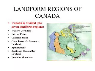
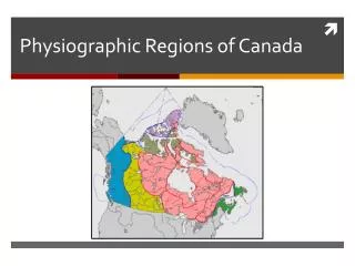
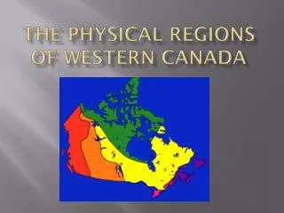
Regions of Canada. Covers most of the northern half o f North America Shares many physical characteristics with the U.S. Broken down into 10 provinces or political divisions and 2 territories divide the nation into 5 regions based on physical features, culture, and economy.

Regions of Canada
E N D
Presentation Transcript
Covers most of the northern half o f North America • Shares many physical characteristics with the U.S. • Broken down into 10 provinces or political divisions and 2 territories • divide the nation into 5 regions based on physical features, culture, and economy
Canada’s regions are more distinct than those of the U.S. for two reasons • 1. relatively small population • 2. system of government which grants a lot of power to provinces
Atlantic Provinces • Located in the SE corner of Canada • Newfoundland, Prince Edward Island, Nova Scotia, and New Brunswick • Land in this region forms part of the Appalachian Mountains • Thousands of lakes and ponds dot the area • Glaciers once passed over the area and left the soil thin and littered with rocks and boulders
Often called the Maritimes because of their close ties to the sea • Coastline has many harbors • Smallest of the 10 provinces, 5% of total land, and 10% of the population • Nova Scotia makes more money from fishing than any other province- has lead to over fishing and layoffs • Overall lowest income of Canada’s regions
Great Lakes and St. Lawrence Provinces • Core of Canada's population and economy • 60% of population lives here • 3 distinct landscapes • Canadian Shield- poor soil, cold, but rich in mineral deposits • Hudson Bay Lowlands- flat, sparsely populated, swampy region b/w the Canadian Shield and Hudson Bay • St. Lawrence Lowlands- rich soil, mild climate
One of Ontario’s most important features is its systems of waterways • The St. Lawrence Seaway connects the St. Lawrence River with the Great Lakes • “ highway to the sea” due to the large amounts of goods that travel on it • The waterway is controlled by a system of locks- enclosed area on a canal that raises and lowers ships from one water level to another • The U.S. And Canada built a hydroelectric plant here to take advantage of this water movement
Ontario has rich soil good for farming \ • A network of cities has evolved to manufacture cars, food products, clothes , and building materials • Toronto • has the largest metropolitan area in Canada • 1/3 of largest companies in Canada are here • important banking an financial center • Ottawa is the national capital
Prairie Provinces • Alberta, Saskatchewan, and Manitoba found in the SW • Land covered with wheat • Winnipeg, Edmonton, and Calgary are all major cities that were originally linked by the railway laid across the Canadian Shield • Provide most of the cattle and grain for the nation • Tourism, natural gas , and oil have all dramatically effected the economy of the region
British Columbia • Wealthy in natural resources • Victoria, the capital, is a major attraction • Vancouver is the province's largest city, Canada's major port for the Pacific Ocean, and has grown in recent decades due to increased trade with Asia • Population is rising due to Asian immigrants and Canadians looking for a good climate and natural beauty
Northern Territories • The Northern 40% of Canada is made up of the Northwest and Yukon Territories • Contain less than 1% of population, most of the pop. lives along the Arctic coast • Most inhabitants are Natives known as Inuits “ the people” , do not like the term “Eskimo” • Contact with Europeans have modernized seal hunting techniques and education
Mineral rich, yet the climate and rugged terrain make it difficult to tap these resources