1 / 0

Physical Regions of Canada

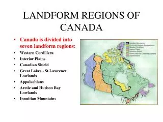
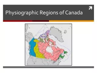
Physical Regions of Canada. How can Canada be divided into physical regions?. Appalachian Region. Southeastern USA to Maritimes Varied landscape of rolling hills, valleys, small mountains , highlands and coastal fjords

myra
Télécharger la présentation

Physical Regions of Canada

An Image/Link below is provided (as is) to download presentation Download Policy: Content on the Website is provided to you AS IS for your information and personal use and may not be sold / licensed / shared on other websites without getting consent from its author. Content is provided to you AS IS for your information and personal use only. Download presentation by click this link. While downloading, if for some reason you are not able to download a presentation, the publisher may have deleted the file from their server. During download, if you can't get a presentation, the file might be deleted by the publisher.

E N D

Presentation Transcript


  1. Physical Regions of Canada How can Canada be divided into physical regions?
  2. Appalachian Region Southeastern USA to Maritimes Varied landscape of rolling hills, valleys, small mountains, highlands and coastal fjords What is left of an older mountain range worn down by glaciers and millions of years of erosion Sedimentary rock Igneous rock Metamorphic rock
  3. The Rock Cycle
  4. Canadian Shield Region ½ of Canada’s land surface Hardest rigid blocks, surrounded by younger continental landforms Once volcanic mountain range 2 billion years old Sparcely populated, little soil fertility Full of valuable minerals: gold, nickel, platinum, diamonds etc.
  5. Arctic Region Untapped mineral reserves
  6. St. Lawrence Lowlands Between Lake Huron, Erie and Ontario Glacial melt created great lake and fertile soil surrounding St. Lawrence Niagara Falls – created by glacier activity Millions of years ago.
  7. Interior Plains Stretched from Cordillera mountians to Canadian shield Mostly flat land rolling hills and river valleys Millions of years ago was tropical climate – over time remains pressed between sedimentary layers to form large deposits of fossil fuels such as oil and natural gas and evaoritessuch as potash Evaporite– type of sedimentary deposit resulting from the evaporation of seawater
  8. Cordillera Parallel mountain ranges Includes dormant volcanoes, glaciers, ice fields Rocky and Coastal mountains Formed by plate collision caused the earth’s crust to buckle, pushing and folding volcanic rock into mountains. Plate movement called plate tectonics
  9. Climates of Canada Climate - temperatures, humidity, rainfall, and atmospheric conditions of a region over a long period of time Continental climate – climate of continents interior Maritime climate – a coastal climate Conditions that affect Canada’s regions (old p.104, new p.25) Latitude Altitude Distance from the sea Wind direction Ocean direction Prince Rupert, Edmonton, and St.John’s are all app. same latitude, yet have different climates. What are the main reason the climate of each city is different from the other two?
  10. Climographs (old p.105, new p.26)precipitation and temperature Precipitation - Rainfall, snow, hail and fog – varies by region Climographs– show average monthly temp. with line graph and monthly precipitation with bar graph
  11. Climate Change Past 200 years world’s become more industrialized and burns massive amounts of fossil fuels (coal, oil, natural gas) - trapped green house gases in atmosphere Greenhouse effect – change of weather patterns List 3 impacts climate change has had on your community. In what ways has if affected you and your family? (socially, economicaly, politically?)
More Related