Download
1 / 25
250 likes | 267 Vues
Landform Regions of Canada. An important theme in Geography is Space. Not Outer Space. The area of the earth is 150,000,000 sq km. The area of Canada is 9,976,140 sq km. Land Form Regions.

E N D
Landform Regions of Canada An important theme in Geography is Space Not Outer Space The area of the earth is 150,000,000 sq km The area of Canada is 9,976,140 sq km
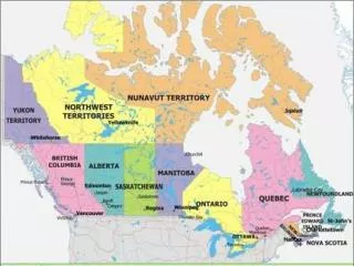
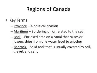
Land Form Regions In order to help describe the Large space that Canada occupies, Canada has been divided in a number of different way. One way in which Canada has been divided is politically.
Land Form Regions Today we are concerned with “Landform Regions” A landform region is an part of the earth with a unique set of physical features that people often use to meet their needs.
Mushroom cut Cartoon character Short Shorts So when we are talking about Land Form regions we are talking about Physical Characteristics.
Few People Lakes Igneous Rock Christmas Trees (Coniferous Trees) Physical Characteristics
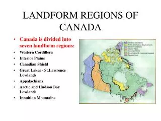
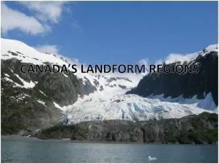
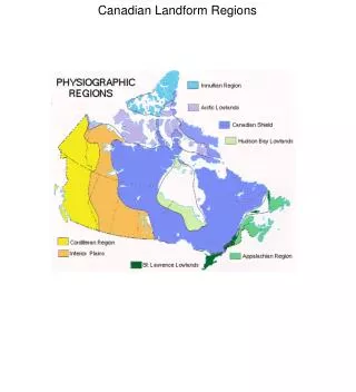
Land Form Regions of Canada Canada has Seven Land Form Regions Can you think of where these Regions might be located? Hint: Think of the Various Physical Characteristics of the Provinces and Territories
So Why Does Canada have different Physical Characteristics in different Regions? Well… Not all of Canada is the Same age…. The longer the region has been around the longer it has been effected by the forces of Erosion. Older Region = More Erosion
Your Text book compares the growth of Canada to a Tree Trunk growing out from the center. But Canada did not grow Evenly….
The Canadian Shield Characteristics Formed by Volcanoes starting 3 billion years ago. Igneous and Metamorphic Rock. Glaciers = Billions of years of Erosion … they scraped away much of the soil and marked the land with hollows and depressions. This created a land of lakes and swamps some glacial lakes dried up forming clay belts with good soil.
Great-Lakes St. Lawrence Lowlands • A Low Lying Area • Sedimentary Rock which eroded from the Canadian Shield. • Rock is about half a billion years old. Glaciers deposited a lot of soil Glaciers scraped out large basins = Great Lakes.
Niagara Escarpment <Back> The Niagara Escarpment formed because the escarpment is made of hard Limestone rock surrounded by softer sedimentary stone like Sandstone and Shale. Niagara Falls is an example of the Escarpment.
The Appalachians The mountains of the Appalachian region began to form 250 million years ago Plate movements forced Sedimentary rock to fold upwards Forces of Erosion ground the mountains down to a fraction of their height and the ocean has eroded the coast line forming many natural harbors.
Interior Plains Wide open area, with no Mountains and few trees. Mostly 200 million year old sedimentary rock. Ancient sea beds. Glaciers deposited very rich soil
Western Cordillera • Igneous, Metamorphic and Sedimentary rocks. • Rocky Mountains • Formed by Volcanos and folding • Interior Plateau
The Innuitians Another Region formed the same way as the Appalachians and the Rockies. It is the middle child, older than the Rockies and younger than the Appalachians. Sedimentary Rock Currently covered by Large Glaciers.
Arctic Cold! The coldest day in Canada was at Pelly Bay, Nunavut. The temperature with the wind chill was -91 Celsius. Islands = Sedimentary Rock. The land has been scraped bare by moving Ice = Erosion
Now we have examined Physical Characteristics and Climate but how does it effect us? Rocks And Resources Population
Rocks & Resources <Back>
Population <Back>
the Canadian Shield Poor Soil, Coniferous Trees Few Major Cities Hydroelectricity Mining
the Great Lakes–St. Lawrence Lowlands Escarpment Large Cities Industrial Heartland
the Appalachians Sedimentary Mountains Many Natural Harbors A few cities over 100’000
Interior Plains Oil and Natural Gas Farming Flat Sedimentary Rock 2 cities nearing 1 million
Western Cordillera Sedimentary Mountains Tourism Igneous Mountains Large population in the Victoria-Vancouver Area