Download
1 / 24
240 likes | 430 Vues
North Carolina Drought 2007-2008. National Weather Service Newport/Morehead City, NC Sarah Jamison. Drought 2007-2008. Started in and out of drought conditions in the western part of the state in 2006

E N D
North Carolina Drought 2007-2008 National Weather Service Newport/Morehead City, NC Sarah Jamison
Drought 2007-2008 • Started in and out of drought conditions in the western part of the state in 2006 • Persistant dry and warm conditions in spring 2007 kept the area in an expanding and deepening drought status • Drought “peak” in late summer of 2008 • Conditions gradually improving from east to west in late 2008 and into early 2009.
Spring 2007 • Developing La Nina in equatorial Pacific • Less active severe season over NC, and subsequently less rainfall • Dominant high pressure over the southeast led to warmer than normal temperatures.
Spring 2007 • Drought conditions begin to overspread the southeast and most of NC
Summer 2007 • August Heat Wave-Temperatures soared in late July and early August, which enhanced the amount of evaporation.
Summer 2007 • Ground water and soil moistures began to deteriorate, with impacts on crops and water reservoirs increasing
Tropical Season 2007 • Relatively dry tropical season • Only direct strike was TS Gabrielle on September 9 • Heavy rainfall isolated to near the coast where >9” of rain fell. However most areas remained dry. • Seasonal rainfall well below normal due to lack of tropical rains
2007 Summary 2007 Rainfall Departure from Normal • State annual precipitation amounts were significantly drier than normal with many areas receiving 25-20% of normal
Winter/Spring 2008 • 2008 started off with initial drought conditions ranging from severe (D2) to exceptional (D4).
Winter/Spring 2008 • Near normal rainfall, heavier in the east improved drought conditions in the late winter/spring months.
2008 Summer June monthly rainfall departure from normal • Below normal rain during the summer months deteriorated conditions again.
2008 Summer • Above normal temperatures combined with below normal rainfall to deteriorate conditions again. August is typically one of the wettest months of the year, so low rainfall amounts added significantly to annual precipitation deficits.
2008 Tropical Summary • Tropical Storm Cristobal: 7/20/08
2008 Tropical Summary • Tropical Storm Hanna, 9/6/08 • Best rain over central part of state, >5” • None in west and 1-3” in east
2008 Tropical Summary • Drought result form tropical activity. Big improvement in the central part of the state. No change in west or east.
2008 Fall/Winter November radar estimated monthly precipitation • Heavy rainfall in east from coastal storms improved drought conditions there. West still struggled to break drought.
2008 Summary 2008 Rainfall Departure from Normal • Year to date precipiation amounts were better than 2007, yet still below normal for most areas.
Drought Summary • Though the majority of the state has improved in soil moisture and ground water by the end of 2008, conditions are still considered below normal and could fall back into a drought again if 2009 continues to be dry and warm.
Drought Summary Animation of annual drought maps for 2007
Drought Summary Animation of annual drought maps for 2008
2009 Outlooks • CPC precipitation seasonal outlooks show a greater chance of below normal rainfall over the winter/spring months and equal chances by summer.
2009 Outlooks • CPC temperature seasonal outlooks show an equal chances of above/below/normal temperatures this spring/summer.
ENSO Outlooks The CFS ensemble mean (heavy blue line) indicates La Niña conditions through Spring 2009.
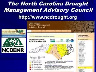
Resources/Related Links • NC Drought Advisory Board, www.ncdrought.org • U.S. Drought Monitor, drought.unl.edu/dm/monitor.html • Natioanl Hurricane Center www.nhc.noaa.gov/2008atlan.shtml • Climate Prediction Center www.cpc.noaa.gov • Hydrologic Prediction Center www.hpc.ncep.noaa.gov • National Integrated Drought Information System (NIDIS) www.drought.gov