Download
1 / 4
40 likes | 154 Vues
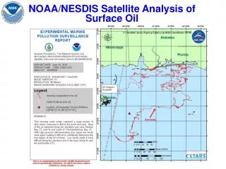
NOAA/NESDIS Satellite Analysis of Surface Oil. Daily Composite. NOAA/NESDIS Satellite Analysis of Surface Oil --. Product Dissemination. trajectories. Coast Guard Local/state responders. NOS/Emergency Response Division Coast Guard (Minerals Management Service). Pre-spill.

E N D
Daily Composite NOAA/NESDIS Satellite Analysis of Surface Oil --
Product Dissemination trajectories • Coast Guard • Local/state responders • NOS/Emergency Response Division • Coast Guard • (Minerals Management Service) Pre-spill affected areas NOAA/NESDIS Satellite Analysis of Surface Oil -- • United States Geological Survey (USGS) • Pentagon and Navy • Dept of the Interior headquarters • Department of Homeland Security • Google, ESRI, NOAA Visualization Lab Now
Charter Activated on April 22, 2010 Serving as Project Manager Charter is still ongoing Received Synthetic Aperture Radar from ESA-Envisat ASAR CSA-RADARSAT 1 &2 JAXA-ALOS Palsar Received high resolution visible imagery from CNES –SPOT ISRO –Oceansat OCM ESA-Envisat MERIS International Charter Space & Major Disasters