Download

1 / 48
550 likes | 1.55k Vues
Satellite Remote Sensing and GIS Applications in Agricultural Meteorology and WMO Satellite Activities. M.V.K. Sivakumar and Robert Stefanski, Agricultural Meteorology Division and Donald E. Hinsman, Satellite Activities Office World Meteorological Organization. Introduction.

E N D
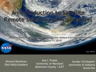
Satellite Remote Sensing and GIS Applications in Agricultural Meteorologyand WMO Satellite Activities M.V.K. Sivakumar and Robert Stefanski, Agricultural Meteorology Division and Donald E. Hinsman, Satellite Activities Office World Meteorological Organization
Introduction • Agricultural planning and use of agricultural technologies need applications of agricultural meteorology. • Agricultural weather and climate data systems are necessary to expedite generation of products, analyses and forecasts that affect: • Agricultural cropping and management decisions, • Irrigation scheduling, commodity trading and markets, • Fire weather management and other preparedness for calamities , and • Ecosystem conservation and management.
Introduction (contd.) • Agrometeorological station networks are designed to observe the data of meteorological and biological phenomena together with supplementary data as disasters and crop damages occur. • The method of observation can be categorized into two major classes, manually observed and automated data collection stations.
Introduction (contd.) • A third source for agrometeorological data that is gaining recognition for its complementary nature to the traditional methods is satellite remote sensing technology.
Introduction (contd.) • Remotely sensed data and AWS systems provide an enhanced and very feasible alternative to manual observation for a very short time span between data collection and transmission. • Availability of new tools such as Geographic Information Systems (GIS) enables management of an incredible quantity of data such as traditional digital maps, database, models possible.
Introduction (contd.) • The advantages are manifold and highly important, especially for the fast cross-sector interactions and the production of synthetic and lucid information for decision-makers. • Remote sensing provides the most important informative contribution to GIS, which furnishes basic informative layers in optimal time and space resolutions.
The Commission for Agricultural Meteorology (CAgM) of WMO, Remote Sensing and GIS • Agricultural meteorology had always been an important component of the National Meteorological Services since their inception. • A formal Commission for Agricultural Meteorology (CAgM) which was appointed in 1913 by the International Meteorological Organization (IMO), became the foundation of the CAgM under WMO in 1951. • The WMO Agricultural Meteorology Programme is coordinated by CAgM.
CAgM, Remote Sensing and GIS (contd.) • The Commission is responsible for matters relating to applications of meteorology taking into account new developments in the scientific and practical fields and the development of agricultural meteorological services of Members by transfer of knowledge and methodology and by providing advice. • CAgM recognized the potential of remote sensing applications in agricultural meteorology early in the 70s.
CAgM, Remote Sensing and GIS (contd.) • At its sixth session in Washington in 1974, CAgM agreed on the importance of studies on the application of remote sensing techniques to agrometeorological problems and decided to appoint a rapporteur to study the existing state of the knowledge of remote sensing techniques and to review its application to agrometeorological research and services. • At its seventh session in Sofia, Bulgaria in 1979, the Commission reviewed the report submitted by Dr A.D. Kleschenko (USSR) and Dr J.C. Harlan Jr (USA) and noted the promising future for the use in agrometeorology of data from spacecraft and aircraft and that rapid progress in this field required exchange of information on achievements in methodology and data collection and interpretation.
CAgM, Remote Sensing and GIS (contd.) • The Commission at that time noted that there was a demand in almost all countries for a capability to use satellite imagery in practical problems of agrometeorology. • The Commission continued to pay much attention to both remote sensing and GIS applications in agrometeorology in all its subsequent sessions up to the 13th session held in Ljubljana, Slovenia in 2002.
CAgM, Remote Sensing and GIS (contd.) • At the session in Slovenia in 2002, the Commission convened an Expert Team on Techniques (including Technologies such as GIS and Remote Sensing) for Agroclimatic Characterization and Sustainable Land Management.
CAgM, Remote Sensing and GIS (contd.) • Training of technical personnel to acquire, process and interpret the satellite imagery was a major task. Acquisition of satellite data was usually much easier than the interpretation of data for specific applications that were critical for the assessment and management of natural resources. • Long-term planning and training of technical personnel was a key ingredient in ensuring full success in the use of current and future remote sensing technologies that could increase and sustain agricultural production, especially in the developing countries.
CAgM, Remote Sensing and GIS (contd.) • WMO already organized a Training Seminar on GIS and Agroecological Zoning in Kuala Lumpur, Malaysia in May 2000 in which six participants from Malaysia and 12 from other Asian and the South-West Pacific countries participated. • The programme for the seminar dealt with meteorological and geographical databases, statistical analyses, spatialization, agro-ecological classification, overlapping of agroecological zoning with boundary layers, data extraction, monitoring system organization and bulletins. • The training workshop organized in Dehradun was in response to the recommendations of the Commission session in Slovenia in 2002 and helped participants from the Asian countries in learning new skills and updating their current skills in satellite remote sensing and GIS applications in agricultural meteorology.
CAgM, Remote Sensing and GIS (contd.) • Useful publications of CAgM: • Use of remote sensing for obtaining agrometeorological information (Kleschenko, 1983), • Operational remote sensing systems in agriculture (Kanemasu and Filcroft, 1992), • Satellite applications to agrometeorology and technological developments for the period 1985-89 (Seguin, 1992), • Statements of guidance regarding how well satellite capabilities meet WMO user requirements in agrometeorology (WMO,1998, 2000) etc.,
GIS applications in Agrometeorology • A GIS generally refers to a description of the characteristics and tools used in the organization and management of geographical data. • The term GIS is currently applied to computerised storage, processing and retrieval systems that have hardware and software specially designed to cope with geographically referenced spatial data and corresponding informative attribute. • Spatial data are commonly in the form of layers that may depict topography or environmental elements.
Model Drivers Model Initialization Model Output Crop Yields Application of Crop Yield Model By GIS Grid Cells Solar Radiation Rainfall Temperature Humidity, etc Soil Moisture Leaf Area Index Crop Phenology Landcover Classification
GIS applications in Agrometeorology • Nowadays, GIS technology is becoming an essential tool for combining various map and satellite information sources in models that simulate the interactions of complex natural systems. • A GIS can be used to produce images, not just maps, but drawings, animations, and other cartographic products.
GIS applications in Agrometeorology (contd.) • The increasing population, coupled with growing pressure on the land resources, necessitates the application of technologies such as GIS to help maintain a sustainable water and food supply according to the environmental potential. • “Sustainable rural development” concept envisages an integrated management of landscape, where the exploitation of natural resources, including climate, plays a central role. Agrometeorology can help reduce inputs and quantify the contribution of ecosystems and agriculture to carbon budget.
GIS applications in Agrometeorology (contd.) • Agroclimatological analysis can improve the knowledge of existing problems for land planning and optimization of resource management. • One of the most important agroclimatological applications is the climatic risk evaluation corresponding to the possibility that certain meteorological events could happen, damaging crops or infrastructure.
GIS applications in Agrometeorology (contd.) • At the national and local level, possible GIS applications are endless. For example, agricultural planners might use geographical data to decide on the best zones for a cash crop, combining data on soils, topography, and rainfall to determine the size and location of biologically suitable areas. • The final output could include overlays with land ownership, transport, infrastructure, labour availability, and distance to market centres. • The ultimate use of GIS lies in its modelling capability, using real world data to represent natural behaviour and to simulate the effect of specific processes.
GIS applications in Agrometeorology (contd.) • Modelling is a powerful tool for analyzing trends and identifying factors that affect them, or for displaying the possible consequences of human activities that affect the resource availability. • In addition to classical applications of agrometeorology, such as crop yield forecasting, uses such as those of the environmental and human security are becoming more and more important. • For instance, an effective forest fire prevention needs a series of very detailed information on an enormous scale. The analysis of data, such as the vegetation coverage with different levels of inflammability, the presence of urban agglomeration, the presence of roads and many other aspects, allows the mapping of the areas where risk is greater.
GIS applications in Agrometeorology (contd.) • The use of other informative layers, such as the position of the control points and resource availability (staff, cars, helicopters, aeroplanes, fire fighting equipment, etc.), can help the decision-makers in the management of the ecosystems. • Monitoring the resources and the meteorological conditions therefore allows, the consideration of the dynamics of the system, with more adherence to reality.
Informative layers for the evaluation of fire risk index (Maracchi et al. 2000)
Pioneers in modern atmospheric science helped pave the way • V2 Rocket photographic montage • J. Bjerknes performed synoptic analyses using pictures such as this in 1948: likely the first serious attempt to analyze the atmosphere from “space” • (WMO formed in 1950)
On April 1, 1960 the first U.S. weather satellite was launched from Cape Canaveral, FL • SATELLITES AND THE WWW • UN Resolution No. 1721 for “international co-operation in the peaceful uses of outer space” approved 20 December 1961 • Advent of satellites offered substantial opportunities for improvements in meteorological services • Called on WMO to lead a study and report on recommendations of the UN Resolution • Report delivered in June 1962 • “First report on the advancement of atmospheric sciences and their application in the light of developments in outer space” • Birth of World Weather Watch
On April 1, 1960 the first U.S. weather satellite was launched from Cape Canaveral, FL • First TIROS television vidicon pictures presented several challenges • Image rectification • Navigation • Cloud type identification • Calibration
Uniqueness of Environmental Satellites • The ability of certain satellites to view a major portion of the atmosphere continually from space makes them particularly well suited for the monitoring and warning of short-lived meteorological phenomena; and • The advanced communications systems developed as an integral part of the satellite technology permit the rapid transmission of data from the satellite, or their relay from automatic stations on earth and in the atmosphere, to operational users.
Uniqueness of Environmental Satellites (contd.) These factors are incorporated in the design of meteorological satellites to provide data, products and services through three major functions: • Remote sensing of spectral radiation which can be converted into meteorological measurements such as cloud cover, cloud motion vectors, surface temperature, vertical profiles of atmospheric temperature, humidity and atmospheric constituents such as ozone, snow and ice cover, ozone and various radiation measurements; • Collection of data from in situ sensors on remote fixed or mobile platforms located on the earth's surface or in the atmosphere; and • Direct broadcast to provide cloud-cover images and other meteorological information to users through a user-operated direct readout station.
Satellite Remote Sensing • Remote sensing provides spatial coverage by measurement of reflected and emitted electromagnetic radiation, across a wide range of wavebands, from the earth's surface and surrounding atmosphere. • Improvements in technical tools of meteorological observation, have created a favourable substratum for research and monitoring in many applications such as agriculture and forestry.
Satellite Remote Sensing • Each waveband provides different information about the atmosphere and land surface: surface temperature, clouds, solar radiation, processes of photosynthesis and evaporation, which can affect the reflected and emitted radiation, detected by satellites. • The challenge for research therefore is to develop new systems extracting this information from remotely sensed data, giving to the final users, near-real-time information.
Satellite Remote Sensing (contd.) • Over the last two decades, the development of space technology has led to a substantial increase in satellite earth observation systems. • Simultaneously, the Information and Communication Technology (ICT) revolution has effectively increased the processing of data for specific uses and their instantaneous distribution on the World Wide Web (WWW). • The global meteorological community are now able to take advantage of a wealth of observational data, product and services flowing from specially equipped and highly sophisticated environmental observation satellites.
Satellite Remote Sensing (contd.) • An environmental observation satellite is an artificial Earth satellite providing data on the Earth system and a meteorological satellite is a type of environmental satellite providing meteorological observations. • An environmental satellite can provide a regular supply of data from those areas of the globe yielding very few conventional observations; • The atmosphere is broadly scanned from satellite altitude and enables large-scale environmental features to be seen in a single view;
Nominal configuration of the space-based sub-system of the Global Observing System in 1978
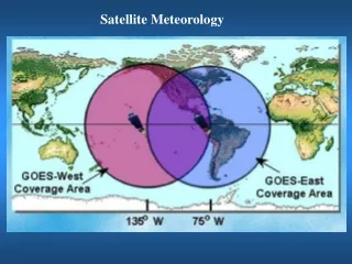
Geostationary spacecraft • Geostationary satellites provide a continuous view of weather systems making them invaluable in following the motion, development, and decay of such phenomena. • They operate in the equatorial belt and give a continuous view of the weather from roughly 70N to 70S. • Each geostationary satellite’s instruments covers about ¼ of the planet almost continuously and there are now six geostationary satellites providing a combined coverage of almost 75%. • Even short-term events such as severe thunderstorms, with a life-time of only a few hours, can be successfully recognized in their early stages and appropriate warnings can be quickly provided to the general public. This capability has been the primary justification for the geostationary spacecraft.
Polar orbiting satellites • Since 71% of the Earth's surface is water and even land areas have many sparsely inhabited regions, the polar-orbiting satellite system provides the data needed to compensate the deficiencies in conventional observing networks. • Spacecraft is able to acquire data from all parts of the globe in the course of a series of successive revolutions. • For these reasons the polar-orbiting satellites are principally used to obtain: (a) daily global cloud cover; and (b) accurate quantitative measurements of surface temperature and the vertical variation of temperature and water vapour in the atmosphere. • Most polar satellite instruments observe the entire planet once or twice in a 24-hour period.
Satellite Remote Sensing • By 2000, WMO Members contributing to the space-based sub-system of the Global Observing System had grown. • The geostationary and polar-orbiting satellites are the two major systems in the space-based Global Observing System (GOS). • 40 years after the first earth images, new systems are still being designed and implemented, illustrating the continued and dynamic interest in this unique source of environmental data.
40 Years Later • Observations are provided by both low earth orbiting (mainly polar for global observing) and geostationary satellites (maximizing the temporal domain) • We utilize many portions of the electromagnetic spectrum • Ultraviolet – Ozone profiling and monitoring • Visible and Infrared - Observing various atmospheric, oceanic and land related properties • Microwave – active and passive observations of sea state, land properties, precipitation, and diagnosing atmospheric thermodynamic structure
Satellite data for meteorology • Satellite data provide better coverage in time and in area extent than any alternative and cover the world’s oceans, deserts, forests, polar regions, and other sparsely inhabited places. • Surface winds over the oceans from satellites are comparable to ship observations; ocean heights can be determined to a few centimetres; and temperatures in any part of the atmosphere anywhere in the world are suitable for computer models.
Satellite data for meteorology • The existing network of environmental satellites, forming part of the GOS of the World Weather Watch produces real-time weather information on a regular basis. This is acquired several times a day through direct broadcast from the meteorological satellites by more than 1,300 stations located in 125 countries. • This added data source is one of the factors in the increased accuracy of daily weather forecast (1-5 day) over the past several decades.
WMO Satellite Activities The World Meteorological Organization, a specialized agency of the United Nations, has a membership of 187 states and territories (as of June 2003). Amongst the many programmes and activities of the organization, there are three areas which are particularly pertinent to the satellite activities: • To facilitate world-wide cooperation in the establishment of networks for making meteorological, as well as hydrological and other geophysical observations and centres to provide meteorological services; • To promote the establishment and maintenance of systems for the rapid exchange of meteorological and related information; • To promote the standardization of meteorological observations and ensure the uniform publication of observations and statistics.
Coordination group for meteorological satellites (CGMS) • In 1972 a group of satellite operators formed the Co-ordination of Geostationary Meteorological Satellites (CGMS) that would be expanded in the early 1990s to include polar-orbiting satellites and changed its name - but not its abbreviation - to the Co-ordination Group for Meteorological Satellites. • CGMS provides a forum for the exchange of technical information on geostationary and polar orbiting meteorological satellite systems, such as reporting on current meteorological satellite status and future plans, telecommunication matters, operations, inter-calibration of sensor, processing algorithms, products and their validation, data transmission formats and future data transmission standards.
WMO Space Programme • Created in May 2003 by the 14th WMO Congress, it is a cross-cutting programme to increase the effectiveness and contributions from satellite systems to WMO programmes • Guiding principles: optimization of the space-based system and the use of existing WMO structures fundamental • Coordinates between operational and R&D space agencies in such areas as frequency coordination, orbit coordination including equator crossing-times, standardization of data formats, standardization of user stations
WMO Space Programme (contd.) • Regional workshops to make WMO Members aware of new capabilities • Education and training events for R&D satellite data and products • Workshops to identify selected instruments for transition from R&D to operational • Recognition of the importance or R&D satellite data in meeting WMO observational data requirements and the subsequent development of a set of Guidelines for requirements for observational data from operational and R&D satellite missions.
Space-based sub-system of the Global Observing System in 2003
Conclusions • Recent developments in remote sensing and GIS hold much promise to enhance integrated management of all available information and the extraction of desired information to promote sustainable agriculture and development. To this end it is important to reinforce training in these new fields. • The promotion of new specialised software should make the applications of the various devices easier by integrating several types of data inputs from standard networks, radar and satellites, meteorological and climatological models, digital cartography and crop models based on the scientific acquisition of the last twenty years. • International cooperation is crucial to promote the much needed applications in the developing countries and the WMO Space Programme actively promotes such cooperation.