S-Map soil
LUNZ & LENZ. StockCCap. FertReq. Curvature horiz. PinRadGrow. LUC. Rock. ECOSAT Indig. Forest. Height. NZLRI. Curvature perp. S-Map soil. ECOSAT Woody. Aspect. Veg. Slope. ECOSAT veg. Curvature slope. ECOSAT fPAR. Slope. Erosion. Soil. S-map Landform Elements.

S-Map soil
E N D
Presentation Transcript
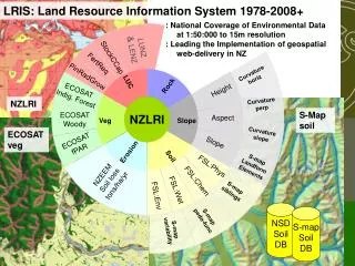
LUNZ & LENZ StockCCap FertReq Curvature horiz PinRadGrow LUC Rock ECOSAT Indig. Forest Height NZLRI Curvature perp S-Map soil ECOSAT Woody Aspect Veg Slope ECOSAT veg Curvature slope ECOSAT fPAR Slope Erosion Soil S-map Landform Elements FSL:Phys NZEEM Soil loss tons/ha/yr FSL:Chem S-map siblings FSL:Wet FSL:Env S-map pedo-func S-map variability LRIS: Land Resource Information System 1978-2008+ : National Coverage of Environmental Data at 1:50:000 to 15m resolution : Leading the Implementation of geospatial web-delivery in NZ NZLRI NZLRI NSD Soil DB S-map Soil DB
nzBugs Soils nzFungi G I S nzFlora NIVS Landcare Science Portals
http://gis.massey.landcareresearch.co.nz/~cwm/portal/http://www.landcareresearch.co.nz/databases/ebopsoils/http://gis.massey.landcareresearch.co.nz/~cwm/portal/http://www.landcareresearch.co.nz/databases/ebopsoils/ Smap Web Pilot
Pilot: Distributed Architecture User Portal WF Engine NZFSL WMS QMAP WMS
SCENZ-Grid MySCENZ-Grid WPS MyExperiment Taverna Computation Collaboration Globus Toolkit Geonetwork / Metadata Geoserver Postgis / SqlServer Data Web Portal GeoWebcache LRIS Backbone