Monitoring Lovland Forest Ecosystems: Insights from Croatian Forest Research Institute
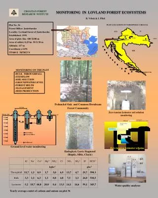
This report discusses the monitoring efforts in the Lovland forest ecosystem, Jastrebarsko, managed by the Croatian Forest Research Institute. Established in 1991, the 1ha plot (Plot No. 36) includes subplots utilized for studying forest health and water dynamics. Key focus areas include bulk throughfall, stemflow, soil solution, groundwater levels, and seed production. The soil is characterized as Endogleyic Luvic Stagnosol, and a zero-tension lysimeter system is employed for monitoring soil solutions. Annual cation and anion analyses further contribute to our understanding of the forest's ecological health.

Monitoring Lovland Forest Ecosystems: Insights from Croatian Forest Research Institute
E N D
Presentation Transcript
MONITORING IN LOVLAND FOREST ECOSYSTEMS CROATIAN FOREST RESEARCH NSTITUTE B. Vrbek & I. Pilaš Plot No. 36 Forest Office: Jastrebarsko Locality: Lovland forest of Jastrebarsko Established: 1991 Area of plot: 1ha 100 X100 m Area of sublot: 0,25 ha 50 X 50 m Altitude: 117 m Coordinate:s GPS 555409 E 5055853 N Soil map MONITORING ON THE PLOT -BULK THROUGHFALL -STEMFLOW-SOIL SOLUTION-GROUNDWATER LEVEL -FOREST HELTH-MANAGEMENT-SEED PRODUCTION Zero tension lysimeter soil solution monitoring Peduncled Oak and Common Hornbeam Forest Community Ground level water monitoring Zero tension lysimeter schema Endogleyic Luvic Stagnosol (Ruptic, Siltic, Clayic) Water quality analyses Yearly average contet of cations and anions on plot 36