Download

1 / 65
650 likes | 828 Vues
Suzanne Wetzel Seemann Jonathan E. Martin Scott Bachmeier October 4, 2001 5 th Annual High Plains Conference North Platte, NE. An Operational Ingredients-Based Methodology for Forecasting Midlatitude Winter Season Precipitation. http://speedy.meteor.wisc.edu/~swetzel/winter

E N D
Suzanne Wetzel SeemannJonathan E. MartinScott Bachmeier October 4, 2001 5th Annual High Plains ConferenceNorth Platte, NE An Operational Ingredients-Based Methodology for Forecasting Midlatitude Winter Season Precipitation http://speedy.meteor.wisc.edu/~swetzel/winter reference: Wetzel and Martin, 2001. Weather and Forecasting,16 (1), 156-167.
Outline Introduction to the Ingredients-Based Methodology Choice of Ingredients and Selected Diagnostics Application of the Methodology and Ingredients Maps Advantages and Limitations October 4, 2001 5th Annual High Plains Conference
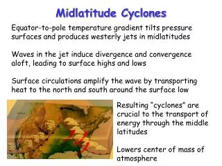
Ingredients-Based Forecast Methodology The Ingredients-Based Forecast Methodology (IM) provides a framework for a systematic assessment of the fundamental physical ingredients that influence the duration, intensity, and type of winter precipitation. • Based on physical principles • Flexibility to accommodate a variety of synoptic and thermodynamic conditions. October 4, 2001 5th Annual High Plains Conference
Ingredient vs. Diagnostic An ingredient is a fundamental physical element or process that directly contributes to the development and intensity of a precipitation event. October 4, 2001 5th Annual High Plains Conference
Ingredient vs. Diagnostic An ingredient is a fundamental physical element or process that directly contributes to the development and intensity of a precipitation event. A diagnosticis the observable or derived quantity that can be used to assess the presence and strength of an ingredient. October 4, 2001 5th Annual High Plains Conference
Ingredient vs. Diagnostic An ingredient is a fundamental physical element or process that directly contributes to the development and intensity of a precipitation event. A diagnosticis the observable or derived quantity that can be used to assess the presence and strength of an ingredient. Parameters will be introduced to diagnose each ingredient; however, the IM is not dependent on these specific diagnostics. October 4, 2001 5th Annual High Plains Conference
Choice of Ingredients 1. Forcing for ascent: Where and how strong is the forcing? 3. Moisture: Where and how much moisture is available? October 4, 2001 5th Annual High Plains Conference
Choice of Ingredients 1. Forcing for ascent: Where and how strong is the forcing? 2. Atmospheric Stability: Will there be an enhanced response to the forcing? 3. Moisture: Where and how much moisture is available? 4. Precipitation Efficiency: How will cloud microphysical characteristics affect the precipitation rate? October 4, 2001 5th Annual High Plains Conference
Choice of Ingredients 1. Forcing for ascent: Where and how strong is the forcing? 2. Atmospheric Stability: Will there be an enhanced response to the forcing? 3. Moisture: Where and how much moisture is available? 4. Precipitation Efficiency: How will cloud microphysical characteristics affect the precipitation rate? 5. Temperature: What form will the precipitation take, and what snow-to-water ratio is expected? October 4, 2001 5th Annual High Plains Conference
Ingredient 1: Forcing for Ascent Quasi-Geostrophic (QG) Forcing Diagnostic Q-Vector convergence Forcing for upward vertical motion Use of the Q-vector as the sole means of diagnosing vertical motion forcing is limiting October 4, 2001 5th Annual High Plains Conference
Ingredient 1: Forcing for Ascent (cont’d) Top right white contours: QG forcing diagnostic (for an 80km grid) October 4, 2001 5th Annual High Plains Conference
Ingredient 1: Forcing for Ascent (cont’d) Diagnostic of Non-QG Forcing: Full Wind Frontogenesis • Includes ageostrophic “thermally direct/indirect” • circulations. October 4, 2001 5th Annual High Plains Conference
Ingredient 1: Forcing for Ascent (cont’d) Diagnostic of Non-QG Forcing: Full Wind Frontogenesis • Includes ageostrophic “thermally direct/indirect” • circulations. Examples of other forcing mechanisms: Orographic forcing Thermodynamic forcing (diabatic & lake-effect) October 4, 2001 5th Annual High Plains Conference
Ingredient 1: Forcing for Ascent (cont’d) Bottom left white contours: Non-QG forcing diagnostic Full-wind frontogenesis October 4, 2001 5th Annual High Plains Conference
Ingredient 2: Atmospheric Stability Instability Diagnostic Saturated equivalent potential vorticity Conditional instability (CI or CSI) is diagnosed where PVes is negative PVes“combines vertical [CI] and slantwise [CSI] instabilities and so becomes an all-purpose convection potential tool.” (McCann, 1995) October 4, 2001 5th Annual High Plains Conference
Ingredient 2: Atmospheric Stability (cont’d) Colored contours: Instability diagnostic October 4, 2001 5th Annual High Plains Conference
Ingredients 1 & 2 Combined: PVQ for negative and negative for positive or positive PVQ is not intended as a numerical quantity, but as a graphical aid to identify where instability and forcing are co-located October 4, 2001 5th Annual High Plains Conference
Ingredients 1 & 2 Combined: PVQ (cont’d) white contours colored contours green contours October 4, 2001 5th Annual High Plains Conference
Ingredient 3: Moisture Moisture Diagnostics • Absolute Moisture: Mixing Ratio • Degree of Saturation: Relative Humidity red contours: mixing ratio (g/kg) filled contours: relative humidity (%) October 4, 2001 5th Annual High Plains Conference
Ingredient 4: Precipitation Efficiency 1. Ice Nucleation (Initiation): Is ice present in the cloud? 2. Ice Crystal Growth: After ice has been initiated, how do the crystals grow to larger snowflakes? Under what conditions do maximum growth rates occur? D.A. Baumgardt, SOO NWS LaCrosse, WI: http://www.crh.noaa.gov/arx/micrope.html October 4, 2001 5th Annual High Plains Conference
Ingredient 4: Precipitation Efficiency (cont’d) How do clouds initiate ice from supercooled liquid droplets? Without ice nuclei, T < - 40 oC With ice nuclei present, T < -10 to -20 oC Baumgardt: -12 oC to -14 oC recommended range for a high likelihood of ice -10 oC operational cutoff point for no ice in a cloud Ice crystal growth after initiation Depositional Growth, maximized around -15 oC Growth by Aggregation, maximized around 0 oC October 4, 2001 5th Annual High Plains Conference
Ingredient 5: Temperature 1. Wet-bulb temperature < 0 at all levels above the surface: Snow likely October 4, 2001 5th Annual High Plains Conference
Ingredient 5: Temperature 1. Wet-bulb temperature < 0 at all levels above the surface: Snow likely 2. Wet-bulb temperature > 0 at some level above the surface, decreasing monotonically: 850 hPa 0 to -4 oC T roughly identifies the region of precipitation type transition (“rain edge” of the rain-snow boundary), always apply with caution colored contours 850 hPa Temperature (oC), shaded where negative October 4, 2001 5th Annual High Plains Conference
Ingredient 5: Temperature (cont’d) 3. Elevated Warm Layer Precipitation type depends on whether the ice melts completely to a liquid while falling through the warm layer October 4, 2001 5th Annual High Plains Conference
Ingredient 5: Temperature (cont’d) 3. Elevated Warm Layer Precipitation type depends on whether the ice melts completely to a liquid while falling through the warm layer Cooler Layer Beneath Elevated Warm Layer Rain or Freezing Rain No ice nucleation (T > - 10 oC) & No ice introduced from above Complete Melting* Possible ice nucleation (T < - 10 oC) Partial Melting* Snow or Ice Pellets * Degree of melting determined by relationships based on the warm layer temperature and the depth of the warm layer (Czys et al. 1996, Stewart and King 1988). October 4, 2001 5th Annual High Plains Conference
Application: Ingredients Maps Ingredients maps facilitate the use of the IM by displaying all diagnostics together in a convenient manner QG Forcing & Instability Non-QG Forcing, Temperature & Efficiency Moisture & PVQ October 4, 2001 5th Annual High Plains Conference
Midwestern Winter Storm: January 26-27, 1996 600:650 mb October 4, 2001 5th Annual High Plains Conference
Midwestern Winter Storm: January 26-27, 1996 700:750 mb October 4, 2001 5th Annual High Plains Conference
Midwestern Winter Storm: January 26-27, 1996 800:850 mb October 4, 2001 5th Annual High Plains Conference
Cross-Section Ingredients Maps • Assist in determining precipitation type and efficiency • Identify layers of instability at levels not captured by the isobaric • ingredients maps (800-850, 700-750, 600-650 hPa) • Assess the depth of forecasted dry or moist layers • Distinguish between CI and CSI (provided the flow is 2D and the cross-section is oriented perpendicular to the shear of the geostrophic wind) October 4, 2001 5th Annual High Plains Conference
6-hour ETA model forecast valid at 06Z March 13, 1997 600:650 hPa 700:750 hPa No negative PVes in WI October 4, 2001 5th Annual High Plains Conference
6-hour ETA model forecast valid at 06Z March 13, 1997 Cross Section Ingredients Map colored: Mg: red white dashed October 4, 2001 5th Annual High Plains Conference
6-hour ETA model forecast valid at 06Z March 13, 1997: non-standard pressure layer550:600 hPa Negative PVes in WI October 4, 2001 5th Annual High Plains Conference
Application of the Ingredients-Based Methodology • Precipitation onset and duration: • If an area of forcing coincides with relative humidity > 80%, some • precipitation is likely. October 4, 2001 5th Annual High Plains Conference
Application of the Ingredients-Based Methodology • Precipitation onset and duration: • If an area of precipitation coincides with relative humidity > 80%, • some precipitation is likely. • Intensity of precipitation: • - Related to the strength of forcing • - May be limited by moisture availability and depth of moist layer • - Enhanced response if forcing coincides with instability • - May be modulated by efficiency mechanisms October 4, 2001 5th Annual High Plains Conference
Application of the Ingredients-Based Methodology • Precipitation onset and duration: • If an area of precipitation coincides with relative humidity > 80%, • some precipitation is likely. • Intensity of precipitation: • - Related to the strength of forcing • - May be limited by moisture availability and depth of moist layer • - Enhanced response if forcing coincides with instability • - May be modulated by efficiency mechanisms • Precipitation type: • Rough characterization based on 850 0 to -4 oC transition region • Inspection of forecast and observed soundings is essential October 4, 2001 5th Annual High Plains Conference
Steps In Preparing an Ingredients-Based Forecast 1. Choose a forecast area and evaluate all ingredient parameters at the 850mb, 700mb, and 600mb levels for each forecast hour. 2. Inspect cross-sections and forecast soundings. 3. Compile information into a time series of forecasted storm intensity and precipitation type. 4. Re-evaluate ingredient diagnostics with new model data. 5. Monitor conditions as the storm develops to decide how well the model-predicted ingredient diagnostics are verifying. October 4, 2001 5th Annual High Plains Conference
Case Example: January 26-27, 1996 NWS Storm Report: Major snowstorm across most of Wisconsin. Total snowfall 8-18" except NW and SE corners where only a few inches fell. Maximum snow amounts were just east of LaCrosse (SW Wisconsin). At the height of the storm, thunder and lightning were observed with blizzard conditions. October 4, 2001 5th Annual High Plains Conference
Onset of Precipitation: 12 UTC 26 January 1996 800:850 hPa
Onset of Precipitation: 12 UTC 26 January 1996 700:750 hPa
Onset of Precipitation: 12 UTC 26 January 1996 600:650 hPa
Onset of Precipitation: 12 UTC 26 January 1996 Cross-section
800:850 hPa Period of Peak Intensity 00 UTC 27 January 1996 700:750 hPa 600:650 hPa
Peak Intensity: 00 UTC 27 January 1996 Cross-section
Near Ending 12 UTC 27 January 1996 800:850 hPa
Near Ending 12 UTC 27 January 1996 700:750 hPa
Near Ending 12 UTC 27 January 1996 600:650 hPa