Download
1 / 21
230 likes | 473 Vues
Cartography Study of Mapmaking. Continents. Topography. The shape of the Earth’s surface Raised area are hills or mountains Depressed areas are valleys or craters. Elevation. Height above sea level, measured in feet or meters. Relief. The difference in a region’s elevations.

E N D
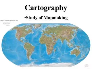
Cartography • Study of Mapmaking
Topography • The shape of the Earth’s surface • Raised area are hills or mountains • Depressed areas are valleys or craters
Elevation • Height above sea level, measured in feet or meters.
Relief • The difference in a region’s elevations. • Which landscape below has a greater relief?
Map • Drawing showing earth’s surface on a plane (flat surface) • Map Projection • Way of showing a curved earth on a flat surface • Globe: A spherical model of earth • most accurate map is a globe • Flat maps distort features because they are not 3-D
Landscape: • Physical features of • Earth’s surface
Longitude • Measures East and West of the Prime Meridian • Meridians • Lines on a map running from N to S • Used to measure Longitude • Numbered 0° to 180° both east and west • Not parallel to each other
Prime Meridian • Meridian that runs through Greenwich, England • This is 0° • What other countries does the Prime Meridian pass through?
Latitude • Measure of distance N or S of the equator • Parallels • All lines on a map running from E to W • Used to measure latitude • Cross Meridians at right angles • Parallel to each other (concentric circles)
Equator • Imaginary line around the Earth that divides it into two hemispheres • The equator is 0°
Understanding Coordinates… • Each degree (1°) of latitude and longitude is equal to 60 minutes (60’) • Each minute (1’) is equal to 60 seconds (60’’) (Atlas activity) (Google Earth)
Topographic Map • Map that shows the different shapes and sizes of a land surface using contour lines. Map view of hill Side view of hill
Contour Line • Line that passes through all points on a map that have the same elevation
Contour Line Basics • Closer lines indicate steeper terrain • Every Point on a contour line has the exact same elevation • Lines separate points of higher elevation from lower elevation • Never cross each other • Contour lines are hashed to show a depression or crater • An irregular bullseye formed by contour lines represents a hill • Lines form a ‘V’ pattern when crossing streams • The ‘V’ always points upstream
Scale • Ratio of distance on a map to the distance on earth • Shows how a map compares in size to earth • Stated Verbally or graphically • Example – 1:24,000
Benchmark • Location of known elevation • Is a marker set into the ground • Shown as BM on a map
Topographic Profile • Shows land features from the side rather than from an overhead view • Made from a topographic map
Time Zones • Longitudinal belt of Earth in which all areas have the same local time • Earth is divided into 24 time zones • Each 15 degrees wide • How many time zones are in the continental US?
International Date Line (IDL) • 180 degree meridian • Not straight
International Date Line • When the line is crossed going west, one day is added • When the line is crossed going east, one day is subtracted • This line is NOT straight so that countries are not divided and have different dates