National GPS Network in Slovenia: Geodetic Signal System
210 likes | 262 Vues
Slovenian geodetic signal system, part of national geospatial infrastructure, aids in transition to new coordinate system. Open for navigation, facilities management, GIS, and more.

National GPS Network in Slovenia: Geodetic Signal System
E N D
Presentation Transcript
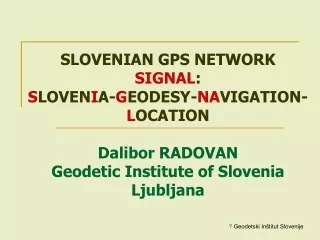
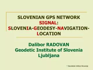
SLOVENIAN GPS NETWORK SIGNAL: SLOVENIA-GEODESY-NAVIGATION-LOCATIONDalibor RADOVANGeodetic Institute of Slovenia Ljubljana
SIGNAL • National GPS network under construction • Part of geospatial infrastructure • Main user: Geodesy • Main task: Transition to a new coordinate system • Open to other users: Navigation, facilities management, GIS
NATIONAL COORDINATE SYSTEM • Bessel ellipsoid • Gauss-Krueger projection • Locally deformed classic triangulation – Datum 1948 • Transformation parameters to/from ETRS 89 available for the entire country and locally
NEW COORDINATE SYSTEM National GPS network SIGNAL + Homogenized network of points in ETRS 89 (EUREF campaigns & additional points) + Classic traingulation in transition time
ORGANIZATION • Surveying and Mapping Authority (SMA) - funds and organization • Geodetic Institute of Slovenia - technical coordination and management (from 2001 on) • 46 SMA branch offices & 150 accredited private companies - execution of geodetic works on local level • Faculty for Civil Engineering & Geodesy - research and consultancy
CURRENT STATUS OF GPS NETWORK • Activities (re)started as late as 2001 • 4 permanent stations + 1 private in networked operation • 1 of them included in EUREF-EPN • Trimble VRS/FKP in operation from the end of 2003 • GPS service in operation at the Geodetic Institute of Slovenia • 50 users • Permanent education system
PLANS • Currently 4 stations in bidding process • Outside SIGNAL: 8 private stations existing (single) • 15 stations planned • Full network until mid 2006 within public-private partnership (SMA + Chamber of private surveying companies)
THE OBJECTIVE • Geodetic accuracy (cm rank)over the whole national territory with 15 stations • Average distance 50 to 70 km • Currently: sub-decimeter accuracy with 5 networked stations • Average distance 70 to 130 km
2.11 DATA DISTRIBUTION POST PROCESSING • Via web server (SMA's home page) REAL TIME
REAL TIMEVia mobile internet – NTRIP (Networked Transport of RTCM via Internet Protokol)
* GSR 1 SLOVENIA IN EPN
COLLOCATED TIDE GAUGE AND GPS STATIONSMA + Agency for environment (meteorology) + ESEAS
GPS SERVICE - CONTACTS • Home page: www.gu-signal.si • Coordination: dalibor.radovan@geod-is.si • Technical: gasper.mahnic@geod-is.si


![[Unix Programming] Signal and Signal Processing](https://cdn3.slideserve.com/5708599/unix-programming-signal-and-signal-processing-dt.jpg)