Soil Classification and Survey
480 likes | 1.42k Vues
Soil Classification and Survey. Objectives. After completing this chapter, you should be able to: Describe the current USDA soil classification system Explain how soil surveys are prepared and used List soil capability classes. Soil Classification. Soil survey

Soil Classification and Survey
E N D
Presentation Transcript
Objectives • After completing this chapter, you should be able to: • Describe the current USDA soil classification system • Explain how soil surveys are prepared and used • List soil capability classes
Soil Classification • Soil survey • Depends on a system of grouping soils of like properties • Soil classification • Helps us to understand, remember, and communicate knowledge about soils • USDA • Uses a systematic approach to organize the soils of the United States
The Soil Taxonomy • The system of the Soil Taxonomy is based, rather, on properties of the soil as it can be observed in the field or laboratory. • It resembles the way plants and animals are grouped according to a system known as a taxonomy—a hierarchical grouping of objects at several levels to show how they relate, where the lowest level is the most specific and the highest level the broadest grouping
Soil order (12) • Broadest category • Further divided into suborders • Suborders (66) • Divided into great groups, subgroups, and families • Families (>8000) • Divided into soil series
Soil Series(>19,000) • Narrowest range of features • Lowest official category in soil taxonomy • Most commonly recognized and useful soil designation • Each of these units is distinct from other units and is the same as the polypedon • Each series is given the name of the town, county, or other location near where the series was first identified. • Some are further subdivided into phases • A phase is a variation of a series based on some factor that affects soil management, such as slope, degree of erosion, or stoniness. • For example, an Ontario loam, 3 percent to 6 percent slope phase. • Soil series with their phases become mapping units for the most detailed soil surveys.
Soil Orders • Alfisols: deciduous forests of temperate, moist climates • Andisols: recent geologic volcanic materials • Aridisols: arid climates of cool to hot deserts • Entisols: lack well-developed horizons • Gelisols: very cold soils of the tundra
Soil Orders (cont’d.) • Histosols: decaying organic matter in wetlands • Inceptisols: young, but more developed than Entisols • Mollisols: rich, dark soils of grasslands • Oxisols: highly weathered soils of the tropics
Soil Orders (cont’d.) • Spodosols: coniferous forests in cool, moist regions • Ultisols: highly weathered soils in warm, humid climates • Vertisols: parent materials very high in clays that shrink and swell with drying and wetting cycles
Activity -Assignment Describe the 12 soil orders mentioning, where applicable, their: • Physical properties, • Use, • Typical profile , • Where they are found in the US • What percent of the US soil they form. • The element used in the suborder name • Reference: Soil Science textbook, Page 50 -54
frigid, mixed TypicUdipsamment Read the section on Soil Taxonomy on page 48-49 and then identify the parts of the above soil name that represents the: Order Suborder Great Group Subgroup Family
Sandy, mixed Mesic TorriothenticHaplustolls Identify the parts of the above soil name that represents the: Order Suborder Great Group Subgroup Family
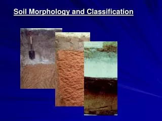
Soil Survey • Classifies, locates, and describes soils as they appear in the field • Tells what soils are in a given location, the properties of the soils, and how they can be used • Field mapping • Typically begins with preliminary study of older soil surveys, if they exist, and documents such as aerial photographs • Aerial photographs make good base maps because they show landscape features, including ponds, woods, and sand pits. • Features visible on the aerial photograph may also indicate the boundaries of various soils. • For detailed mapping, a soil scientist traditionally walks the land to survey it • Frequently the surveyor stops to probe the soil • Maps show the boundaries of the mapping units, with each unit identified by codes that vary from state to state
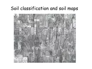
A section of map 28 of the soil survey of Anoka County, Minnesota. Notice areas of Zimmerman soil mentioned in the text, keyed here as Zm. This map, like many others, is now available on the Internet.
Soil mapping symbols that give information about slope, erosion and landscape features
Soil Survey (cont’d.) • Mapping units • Used in soil surveys, depending on how large an area the map or survey covers • For small areas, mapping units are detailed phases of soil series. • For larger-scale maps, the units may be higher levels of the soil taxonomy, like families or great groups. • Soil orders are the mapping units used on some of the national soil map while suborders are the mapping units on some state maps. • For most county maps, phases of soil series are the basic mapping unit. • Where soils are mixed up enough to be difficult to separate on the scale of the map, mapping units may be soil associations or other mapping unit combinations. • A soil association consists of one or more major soils and one or more minor soils,
Technology and soil mapping • Global Positioning system -GPSs, • Geographic information system -GISs, and • Remote sensing -is the acquisition of information about an object or phenomenon without making physical contact with the object • GPS relies on 24 satellites in orbit about the earth, positioned such that any point on the earth’s surface receives a signal from at least four satellites. Using the signal, a GPS unit determines its distance from each satellite; • with readings from four satellites, it can determine its precise position on the earth’s surface. • GISs are powerful computer software programs that organize and integrate data from a variety of sources
Soil Survey (cont’d.) • Soil survey reports • A soil survey report has four major parts: a set of soil maps, map legends that explain the map symbols, descriptions of the soils, and use and management reports for each soil. • These parts provide information on • Taxonomy, descriptions, and properties (e.g. including texture, bulk density, permeability, available water, pH, salinity) • Suitability for development e.g. • urban landscape uses such as turf, ornamentals, and gardening • water-management projects such as reservoirs, drainage, and irrigation • recreational development such as playgrounds and campgrounds • Ratings of suitability for engineering projects such as landfills, buildings, and roads • Potential for Forests or cropping • Potential as a habitat for wildlife
Survey report uses • Soil maps are the heart of good land-use planning • Civil engineers planning a new road will study maps to find routes with good soils for roadbeds • New growers or growers planning to expand find soil maps useful for choosing new land. • Growers can use soil maps in many ways, such as creating a conservation plan. The information in soil surveys helps in planning irrigation, soil erosion control or other projects
Land Capability Classes • The USDA’s Land capability class system, rates soils according to their suitability for agriculture, and also for pasture, rangeland, timber, recreation, and other uses. • Classes • Class I • Class II • Class III • Class IV • Class V • Class VI • Class VII • Class VIII
Land Capability Subclasses • All classes except Class I have one or more limitations • Land capability subclasses indicate factors that limit soil use by means of a single-letter code added to the class number
Activity • Describe the 8 land capability class mentioning the suitability and limitations • Reference: Soil Science textbook, Page 61 -63
Land Capability Subclassess Land capability subclasses indicate factors that limit soil use by means of a single-letter code added to the class number. The letter codes are as follows: e—Runoff and erosion. w—Wetness. s—Root zone or tillage problems. c—Climatic hazard.
Soil Limitation Classes • Soils can also be classified by their limitations for any use • Landscaping, or tree nurseries, or residential streets • USDA offers formal criteria for a number of uses • Information needed to categorize a soil can be found in tables in county soil survey reports
Land-use or interpretive maps • Land users can readily transfer the results of soil ratings for an area onto a soil map to graphically reveal lands suitable or unsuitable for various purposes. • These are land-use or interpretive maps. • On the soil map, mapping units are colored in, often with green (go) for areas with slight limitations, yellow (caution) for those with moderate problems, and red (stop) for unfavorable soils. • GIS software is particularly adept at creating such maps.
Lands of the United States and Elsewhere Nonfederal land in the US excluding Alaska
19 percent of the total land of the United States is arable, compared to about 11 percent of the world. • By comparison, other selected countries include Saudi Arabia at 1 percent arable, Canada 5 percent, Mexico 13 percent, and Ukraine, 56 percent.