Download

1 / 61
640 likes | 1.02k Vues
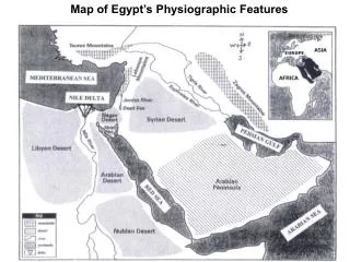
Africa’s Physical F eatures!. Mediterranean Sea. Atlas Mts. Libyan Desert. The Complete Topography Of AFRICA. Tropic of Cancer 20 ° N. Sahara Desert. Red Sea. Sahel. Nile River. Niger River. L. Chad- ->. Great Rift Valley. <--Gulf of Aden. L. Albert -->. Δ Mt. Kenya.

E N D
Mediterranean Sea Atlas Mts. Libyan Desert The Complete Topography Of AFRICA Tropic of Cancer 20° N Sahara Desert Red Sea Sahel NileRiver NigerRiver L. Chad--> Great Rift Valley <--Gulf of Aden L. Albert--> ΔMt. Kenya Equator 0° Congo River L. Victoria ΔMt. Kilimanjaro L. Tanganyika-> Indian Ocean Ruwenzori Mts. Atlantic Ocean Zambezi River Namib Desert Kalahari Desert LimpopoRiver Tropic of Capricorn20° S OrangeRiver Drajensburg Mts. Pacific Ocean
Africa’s Size 4 6 0 0 M I L E S 5000 MILES • Second largest continent 11,700,000 sq. mi. • 10% of the world’s population. • 2 ½ times the size of the U. S.
ESCARPMENTS A long steep slope or cliff at the edge of a plateau or ridge; usually formed by erosion...
Valleys & Plains Great Rift Valley
Great Rift Valley 3,000 miles long
Libyan Desert Deserts Sahara Desert Sahel Namib Desert Kalahari Desert
Sahara • desert in northern Africa • largest desert in the world at 3,500,000 square miles • from Arabic word Al-Sahra
Kalahari Desert • located in south Africa and covers Botswana and parts of Namibia and South Africa • not a “true” desert because it receives 3-10 inches of rain per year • because of the precipitation can sustain some animal life
Sahel • “Transitional Land” • the transitional land between desert land and savanna • semi arid land, which is still dry but gets more rain than the desert
Tropic of Cancer 20° N Africa:The“Tropical”Continent Equator 0° Tropic of Capricorn20° S
Tropical Rainforest • a forest that receives more water through precipitation than is loses through evaporation • What are these processes? • more than 80 inches of rain per year • 1/5 of Africa is rainforest • Africa contains 1 of the 3 major rainforests in the world.
Savanna • tropical or subtropical grassland containing scattered trees • receives enough rain to support drought resistant undergrowth but not enough to support “forest type” vegetation
Bodies Of Water Mediterranean Sea Red Sea NileRiver NigerRiver <--Gulf of Aden Congo River Indian Ocean Atlantic Ocean Zambezi River LimpopoRiver OrangeRiver Pacific Ocean
Nile River • It’s the world’s longest river at 4,150 miles!!! • located in eastern Africa • depended upon for water • Flows north into the Mediterranean sea!
Niger River • principal river in western Africa • runs through Guinea, Mali, Niger, Benin and Nigeria • significant water source for the city of Timbuktu
Congo River • largest river in western central Africa • flows through the third largest rain forest in the world
Zambezi River • southeast African river flowing through Zambia and Angola, also along many of the borders of many countries • empties into the Indian Ocean • contains Victoria Falls
Lake Tanganyika • deepest lake in Africa • located in central Africa • divided between Burundi, Congo, Tanzania, and Zambia
Lake Victoria • largest lake in Africa • 2nd largest fresh water lake in the world • vital in supporting the millions of people that live nearby
Victoria Falls • It’s the largest and most unique waterfall in the world!
Mountains & Peaks Atlas Mts. ΔMt. Kenya ΔMt. Kilimanjaro Ruwenzori Mts. Drajensburg Mts.
Atlas Mountains • mountain range in north Africa between the Mediterranean Sea and the Sahara desert • extends from Morocco to Tunisia
Mount Kilimanjaro • It’s the tallest free standing volcanic mountain in the world! • It is the highest peak in Africa at 19,340 feet!
Southwest Asia
Peninsulas • The biggest peninsula is the Arabian peninsula, which is dominated by Saudi Arabia
The other big one is the Anatolian Peninsula, which is modern-day Turkey.
Bodies of Water Black Sea CaspianSea Dardanelles Strait AtlanticOcean TigrisRiver Mediterranean Sea EuphratesRiver Jordan River Suez Canal Strait ofHormuz Persian Gulf Nile River Gulf ofOman Red Sea ArabianSea Gulf of Aden IndianOcean
Waterways • Red Sea
Jordan River • Important water source that also serves as the boundary between Israel and Jordan. • Flows into the Dead Sea.
The Tigris & EuphratesRiver System Mesopotamia: ”Land Between the Two Rivers” Marsh Arabs, So. Iraq
Tigris and Euphrates Rivers • Twin rivers that run through modern-day Iraq.
The land in between the two rivers is very fertile and a lot of agriculture takes place there. • Because of this, the area is known as the fertile crescent. • Some of the earliest civilizations developed here because of its agricultural bounty.
Suez Canal Completed by the British in 1869
Suez Canal • Connects the Red Sea with the Mediterranean Sea, which makes it a very important waterway.
Black Sea • Just above Turkey.
Arabian Sea and the Persian Gulf • The Arabian Sea is north of the Indian Ocean and the Persian Gulf is sandwiched between Saudi Arabia and Iran.