Download
1 / 1
10 likes | 173 Vues
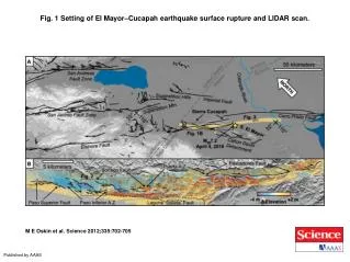
Fig. 1 Setting of El Mayor–Cucapah earthquake surface rupture and LIDAR scan. M E Oskin et al. Science 2012;335:702-705. Published by AAAS.

E N D
Fig. 1 Setting of El Mayor–Cucapah earthquake surface rupture and LIDAR scan. M E Oskin et al. Science 2012;335:702-705 Published by AAAS