Download
1 / 16
160 likes | 191 Vues
Investigate haze causes & sources in GRCA2 & BADL1 areas using preliminary conceptual models. Analyze aerosol data, site conditions, and meteorological factors to refine models.

E N D
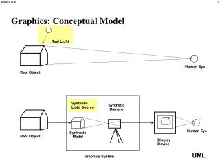
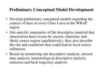
Preliminary Conceptual Model Development • Develop preliminary conceptual models regarding the sources of haze at every Class I area in the WRAP region • Site-specific summaries of the descriptive material that characterize haze events by season, chemistry and likely source region (qualitatively), they also describe the site and conditions that could lead to local source influences • Based on monitoring site descriptive analysis, aerosol data analysis, meteorological descriptive analysis, emission and back trajectory analysis
Conceptual Model Refinement – Additional Analysis • Transport regression analysis • Episode analysis • Receptor Modeling • Trend analysis • Others
Preliminary Conceptual Model - Causes of Haze in Grand Canyon National Park (GRCA2) GRCA2 (Hance Camp at Grand Canyon NP, AZ, Lat. 35.9731, Long. -111.984) is at a regionally exposed location on the south rim of Grand Canyon National Park, with an elevation of 2267 m (7346 ft). Terrain in the vicinity of GRCA2 is forested rolling hills to the south, and drops into the Grand Canyon to the north.
The average PM2.5 mass concentration during the years 1997 to 2002 is 3.1 mg/m3. The overall average total light extinction coefficient (Bext) is 23.8 Mm-1 OMC is the largest contributor to aerosol light extinction in the 20% worst days, with a contribution of 31%. Sulfate also contributes ~28% in the worst days. The highest occurrence of the 20% worst days happened in June and September. CM is the largest aerosol contributor to haze in June. Sulfate and OMC are two of the largest aerosol contributors to light extinction in September.
Best visibility days are mostly associated with northerly flow patterns, while worst haze days are more likely associated with south westerly and south easterly flows. Occasionally, air may transport from the central and eastern United States given suitable meteorology conditions, which usually results in worst haze days.
It indicates important OC sources at southwestern California and northwestern Texas. While it does not happen frequently, air flows from central and southeastern US will usually bring in high OC.
Southwestern Arizona and northwestern Mexico are the major source areas of sulfate at the Grand Canyon. Again, during certain meteorology conditions, air may transport from central and eastern US to the Grand Canyon and result in high sulfate days.
Coarse particles are usually transported from the southeastern California desert area, and occasionally from longer distance such as Africa and Asia. Dust transported from these regions is important contributor to haze in the spring and early summer. Normalized residence time in June
Meteorological Indicators • Subsidence inversions associated with buildup and stagnation of synoptic high pressure ridges are most likely to occur during the summer (July – September), when pressure and temperature gradients in the region are the weakest, and wind circulations therefore weaker. • The highest aerosol concentrations from local sources are likely to occur during synoptic stagnation periods in spring and summer, especially in conjunction with significant wildland burning.
Causes of Haze in Grand Canyon National Park (GRCA2) • Organics emitted from regional forest fires and transported from southwestern California and northwestern Texas, as well as sulfate from southwestern Arizona and northwestern Mexico are the major causes of haze at the Grand Canyon National Park. • Dust from southeastern California desert area and occasionally from longer distance such as Africa is also important contributor to haze in the spring and early summer.
Preliminary Conceptual Model - Causes of Haze in the Badlands Wilderness Area (BADL1) Badlands National Park consists of 244,000 acres of sharply eroded buttes, pinnacles, and spires in southwestern South Dakota. The Badlands National Park Area IMPROVE site BADL1 is located on gently sloping flat in the extreme eastern portion of the National Park, 4 km northeast of the town of Interior. Site elevation is 736 m (2415 ft). The general topography is plains; therefore this site is well exposed to regional scale transport winds
The average PM2.5 mass concentration is 4.0 mg/m3. The average total light extinction coefficient (Bext) is 35.1 Mm-1 (Visual Range ~ 111 Km; Deciview ~ 12.6). The major chemical component that contributes to haze at BADL1 is sulfate. Highest occurrence of the 20% worst days happened in July and August. Sulfate dominates the aerosol light extinction throughout the year
Flows are mainly from west and northwest except in the summer, when southerly flows are dominant.
Southerly flows are dominant in the 20% worst days. Air is mainly transported from the southern and southeastern US, as well as North Dakota and Southern Canada during the worst sulfate days. Normalized residence time for 20% worst days
Causes of Haze in the Badlands Wilderness Area (BADL1) • Sulfate from south and southeastern US, North Dakota and Southern Canada are the major causes of haze at the Badlands Wilderness Area.
Preliminary Conceptual Model - Causes of Haze in the Craters of the Moon Wilderness Area (CRMO1) The Snake River Plain is a large agricultural region extending to Boise and Treasure Valley 300 km west, Idaho Falls and the upper Snake River Plain 100 km east, and Twin Falls and Magic Valley some 80 km south from CRMO1. Agricultural related emission sources include stubble field burning and plowing. Largest urban areas, with associated vehicle and other urban emissions are Boise, Twin Falls, and Idaho Falls/Pocatello. Other emission sources include the Idaho National Engineering Laboratory (INEL), a DOE nuclear research center 25 km east of CRMO1 that has several permitted point sources of NOx and SO2, and large mineral and chemical plants in the Pocatello area, 100 km southeast.