Topographic Map Notes
Topographic Map Notes. 1. Contour lines . Connect points of equal elevation. http://raider.muc.edu/~mcnaugma/Topographic%20Maps/contour.htm. 2. The zero contour line is at sea level. http://raider.muc.edu/~mcnaugma/Topographic%20Maps/contour.htm. 3. Contour interval.

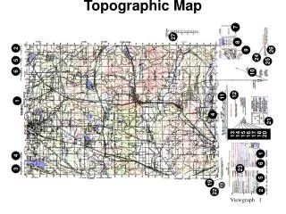
Topographic Map Notes
E N D
Presentation Transcript
1. Contour lines Connect points of equal elevation
http://raider.muc.edu/~mcnaugma/Topographic%20Maps/contour.htmhttp://raider.muc.edu/~mcnaugma/Topographic%20Maps/contour.htm
http://raider.muc.edu/~mcnaugma/Topographic%20Maps/contour.htmhttp://raider.muc.edu/~mcnaugma/Topographic%20Maps/contour.htm
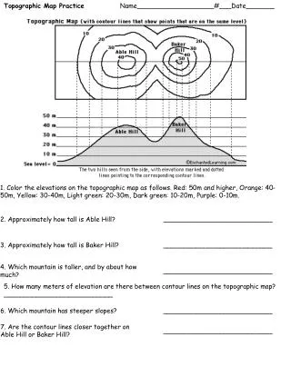
3. Contour interval • The difference in elevation between 2 consecutive contour lines.
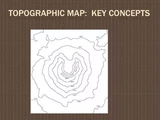
What is the contour interval for this map?(How many feet between each line?) http://raider.muc.edu/~mcnaugma/Topographic%20Maps/contour.htm
4. Index contours • Every 5th line may be darker and numbered rather than every line numbered.
Index contours-notice how every 5th line is numbered. (What is the contour interval?) http://raider.muc.edu/~mcnaugma/Topographic%20Maps/contour.htm
5. Features of a topographic map • A) steep slopes—closely spaced lines • B) gentle slopes—widely spaced lines • C) valley—u or v shaped lines • D) depression—hachure lines on a closed circle • E) mountain—circular contour lines getting smaller and smaller
6. Flat surfaces have a small contour interval (5 feet or 5 meters) • 7. Mountainous areas have a larger contour interval. (40 feet, 100 feet)
8. Contour lines • A) are endless • B) never branch or fork • C) never cross • D) form v’s that point upstream when they cross a stream