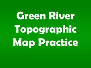
Topographic Map
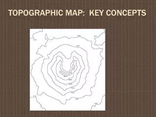
Topographic Map. Topographic Map. The feature that most distinguishes topographic maps from maps of other types is the use of contour lines to portray the shape and elevation of the land. Topographic maps render the three-dimensional ups and downs of the terrain on a two-dimensional surface.


Topographic Map
E N D
Presentation Transcript
Topographic Map The feature that most distinguishes topographic maps from maps of other types is the use of contour lines to portray the shape and elevation of the land. Topographic maps render the three-dimensional ups and downs of the terrain on a two-dimensional surface. Topographic maps usually portray both natural and manmade features. They show and name works of nature including mountains, valleys, plains, lakes, rivers, and vegetation. They also identify the principal works of man, such as roads, boundaries, transmission lines, and major buildings.
Topographic Map The wide range of information provided by topographic maps make them extremely useful to professional and recreational map users alike. Topographic maps are used for engineering, energy exploration, natural resource conservation, environmental management, public works design, commercial and residential planning, and outdoor activities like hiking, camping, and fishing.
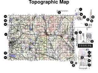
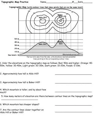
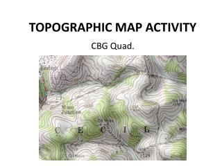
Topographic Map Map at three different scale
Determine Elevation 1. Check contour interval 2. Find given elevation 3. Determine direction of slope 4. Count contour intervals.
Terrain Features Terrain features are identified in the same manner on all maps, regardless of the contour interval, but you must realize that a hill in the Rocky Mountains will be much bigger than one in south Florida. You must be able to recognize all the terrain features to locate a point on the ground or to navigate from one point to another. The five major terrain features are: Hill, Ridge, Valley, Saddle, and Depression. The three minor terrain features are: Draw, Spur and Cliff.
Terrain features can be learned using the fist or hand to show what each would look like on the ground
Hill A point or small area of high ground. When you are on a hilltop, the ground slopes down in all directions.
Ridge A line of high ground with height variations along its crest. The ridge is not simply a line of hills; all points of the ridge crest are higher than the ground on both sides of the ridge.
Valley Reasonably level ground bordered on the sides by higher ground. A valley may or may not contain a stream course. Contour lines indicating a valley are U-shaped and tend to parallel a stream before crossing it.
Saddle A dip or low point along the crest of a ridge. A saddle is not necessarily the lower ground between two hilltops; it may be a break along an otherwise level ridge crest.
Depression A low point or hole in the ground, surrounded on all sides by higher ground.
Draw Similar to a valley, except that it normally is a less developed stream course in which there is generally no level ground and, therefore, little or no maneuver room. The ground slopes upward on each side and toward the head of the draw.
Spur A usually short, continuously sloping line of higher ground, normally jutting out from the side of a ridge. A spur is often formed by two thoroughly parallel streams cutting draws down the side of a ridge
Cliff A vertical or near-vertical slope. A cliff may be shown on a map by contour lines being close together, touching, or by a ticked "carrying" contour line. The ticks always point toward lower ground.
10 Meters 100 Meters 16 03 1000 Meter Reading FT035166
Grid Coordinates The map has vertical lines (top to bottom) and horizontal lines (left to right). These lines form small squares 1,000 meters on each side called grid squares. The lines that form grid squares are numbered along the outside edge of the map picture. No two grid squares have the same number.
Your address is grid square 1181. How do you know this? Start from the left and read right until you come to 11, the first half of your address. Then read up to 81, the other half. Your address is somewhere in grid square 1181.
Grid square 1181 gives your general neighborhood, but there is a lot of ground inside that grid square. To make your address more accurate, just add another number to the first half and another number to the second half - so your address has six numbers instead of four.
To get those extra numbers, pretend that each grid square has ten lines inside it running north and south, and another 10 running east and west. This makes 100 smaller squares. You can estimate where these imaginary lines are.
Suppose you are halfway between grid line 11 and grid line 12. Then the next number is 5 and the first half of your address is 115. Now suppose you are also 3/10 of the way between grid line 81 and grid line 82. Then the second half of your address is 813. Your address is 115813.
The most accurate way to determine the coordinates of a point on a map is to use a coordinate scale. You do not have to use imaginary lines; you can find the exact coordinates using a Coordinate Scale and Protractor.
First, locate the grid square in which the point is located. The number of the vertical grid line on the left (west) side of the grid square is the first and second digits of the coordinates.
The number of the horizontal grid line on the bottom (south) side of the grid square is the fourth and fifth digits of the coordinates.
To determine the third and sixth digits of the coordinates, place the coordinate scale on the bottom horizontal grid line of the grid square containing Point A.
Check to see that the zeros of the coordinate scale are in the lower left hand (southwest) corner of the map grid square.
Slide the scale to the right, keeping the bottom of the scale on the bottom grid line until Point A is under the vertical scale.
On the bottom scale, the 100 meter mark nearest the vertical grid line provides the third digit, 5. On the vertical scale, the 100 meter mark nearest Point A provides the sixth digit, 3. Therefore the six-digit grid coordinate is 115813
Grid Coordinates The precision of a point location is shown by the number of digits in the coordinates: the more digits, the more precise the location. 1996—a 1,000 meter grid square. 192961—to the nearest 100 meters. 19269614—to the nearest 10 met
Measure Distance You can use your map to measure the distance between two places. The maps are drawn to scale. This means that a certain distance on a map equals a certain distance on the earth. The scale is printed at the bottom and top of each map (Scale 1:50,000). This means that 1 inch on the map equals 50,000 inches on the ground. To change map distance to miles, meters, or yards, use the bar scales at the bottom of the map.
Measure Distance Take a ruler or the edge of a paper and mark on it the straight line distance between your two points.
Measure Distance Then, put the ruler or the paper just under one of the bar scales and read the ground distance, in miles, meters, or yards. The bar scale here shows a ground distance of 1500 meters.