Download
1 / 30
320 likes | 526 Vues
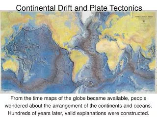
Continental Drift and Plate Tectonics. Wegener 1880-1930. earthobservatory.nasa.gov. Alfred Wegener first proposed the theory of continental drift. Continental drift.

E N D
Continental Drift and Plate Tectonics
Wegener1880-1930 earthobservatory.nasa.gov • Alfred Wegener first proposed the theory of continental drift.
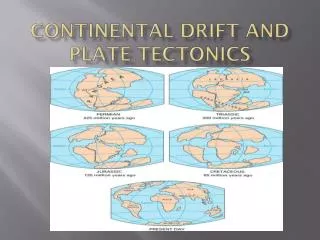
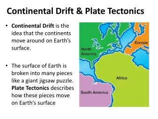
Continental drift • Continental drift was Wegener’s theory that all continents had once been joined together in a single landmass and have drifted apart since. • Wegener named this supercontinent Pangaea. • Wegener’s theory was rejected by scientists because he could not explain what force pushes or pulls continents. Continental drift video clip
Wegener searched and found three main pieces of evidence. Geologic - evidence in the layers of rocks across continents Fossil - evidence in the places certain fossils are found Climate - evidence in the changing climates during the past
Geologic evidence Fit of Continents Across the AtlanticMountain ranges in South America line up exactly with those in Africa!
Fossil evidence http://evolution.berkeley.edu/evolibrary/images/history/fossils3.gif Notice how fossils lined up across continents!
Climate change Amazing Facts: Did you know... ...that India was once in the Southern Hemisphere connected to Antarctica? ...that North America was once surrounded by warm, tropical seas? ...that Africa was once covered by glaciers, which were kilometers in thickness? ...that the Sahara desert was once a tropical rain forest?
An example of the proof for changing climate: At one time, the area that is New Mexico was below the equator! As North America has drifted to different latitudes, changing climates were experienced. This shows the changes in the state of New Mexico.
Wegener's problem He could not find theforcethat was causing the continents to drift. Because of this, he could not convince anyone that continents could move. He died in Greenland on an expedition. At the time of his death, no one believed his hypothesis! Technology developed during the 1940’s changed all that!
Discovery of Sea-Floor Spreading Sea floor spreading video clip
Sea-Floor Spreading m.y. means million years ago Notice this compass. It is important for the next slide
Amazing proof of that the inner core flips! http://platetectonics.pwnet.org/img/blocks.gif As the sea floor spreads, the lava cools according to the magnetic poles at the time. The rocks on the ocean floor have proved that the earth’s magnetic field sometimes reverses. The inner core flips and so the north pole moves to the southern hemisphere! The earthh itself does not flip.
Can you explain this diagram? Click here for a hyperlink to an animation of convection Be sure to click the play button!
Animation of sea floor spreading Can you explain this diagram!?
The place where two plates move apart or diverge is called a divergent boundary.
This is a model of sea floor spreading at a divergentboundary called a mid ocean ridge.
: www.ocean.udel.edu Did you know that the Earth’s longest mountain range is underwater and is called the mid-ocean ridge? The Mid-Ocean Ridge system, shown above snaking its way between the continents, is more than 56,000 kilometers (35,000 mi) long. It circles the earth like the stitching on a baseball!
Plates can also move together! • A convergent boundary is where two plates come together, or converge. The result of the plates hitting together is called a collision.
Plates can also slide past each other. • A transform boundary is a place where two plates slip past each other, moving in opposite directions.
There are three conbinations of how earth's crust can come together. Continental crust to continental Continental crust to oceanic Oceanic crust to oceanic
Continental crust to continental crust collision Before collision India-Asia (Himalayas) After collision from: http://www.geo.lsa.umich.edu/~crlb/COURSES/270
This is how the Himalaya Mountains formed Also the way the Appalachian Mountains formed!
Because one plate gets pushed under another, it is called subduction. This is where volcanoes form! Oceanic crust colliding with oceanic crust Oceanic crust colliding with continental crust all from: http://www.geo.lsa.umich.edu/~crlb/COURSES/270
The process by which the ocean floor sinks beneath a deep-ocean trench and back into the mantle is called subduction
Here is an great link for seeing where each type of boundary is located. Click here for a great hyperlink! Make sure you click on each type of boundary in the key! Plate tectonics video clip
Worldwide Earthquake patterns help us know where the edges of plates are located