Download
1 / 48
500 likes | 746 Vues
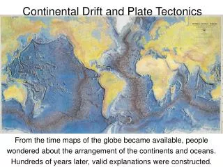
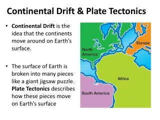
Continental Drift and Plate Tectonics. History of Continental Drift. In German "die Verschiebung der Kontinente" As long as 400 years ago, map makers noted that the continents ’ shapes looked to fit together like a puzzle. LOOK!

E N D
History of Continental Drift • In German "die Verschiebung der Kontinente" • As long as 400 years ago, map makers noted that the continents’ shapes looked to fit together like a puzzle. • LOOK! • Cartographer Abraham Ortelius in his work Thesaurus Geographicus ... suggested that the Americas were "torn away from Europe and Africa ... by earthquakes and floods"
Theory of Continental Drift • 1912: Alfred Wegener proposed that continents move! • Reaction by the scientific community- • HAHAHAHAHAHA. ROFL - ARE YOU KIDDING?
Why did Wegener theorize continental drift? #1 Shape of the continents #2 Fossil clues: • Wegener found similar fossils on different continents • The fossils that he found could probably not have spread between continents • Freshwater reptile fossil • Plant fossil • Similarly evolved species • Why are these two significant? Would finding a bird on two continents support continental drift as well?
#3 Climate clues • Wegener found warm climate fossils in the Arctic and cold climate fossils near the equator. • Warm weather fossils • Evidence of glaciers
#4 Rock clues Wegener found similar strata (layers) of rocks on different continents. • Could this be a coincidence?
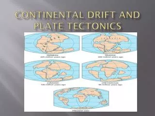
Pangaea – (“all land”) existed about 250 million years ago and began separating around 200 million years ago. • Problem - Wegener’s theoryproposed only that the continents were once one supercontinent and they had “moved” apart but could not explain HOW.
Things Wegener didn’t know: • What the inside of the Earth looked like • That the Earth was broken into plates • That the location of earthquakes and volcanoes shows plate boundaries • Convection Currents • Was his theory accepted by other scientists? • His theory did not become accepted until the 1950’s/1960’s. Why? • Wegener was appreciated posthumously
1960’s: Harry Hess given credit for providing some of the proof necessary to support Wegener’s theory • Hess’s theory of seafloor spreading • Believed that material moved up at mid-ocean ridges and pushed material outward
Why Did Hess believe that the seafloor was spreading? • The discovery of the mid-ocean ridges • Core samples of ocean floor showed that the age of rocks INCREASED the farther they were from mid-ocean ridges • Core samples also showed corresponding magnetic reversals on each side of the mid-ocean ridge
So where are we at this point? • We believe the continents have moved. • These findings provided proof for Hess’s theory and further supported Wegener’s theory • Theory of Plate Tectonics has still not been developed. • But no one still understands why or how the plates move. We are still lacking the MECHANISM.
3 • 1960’s Wilson and other scientists gave mechanism to explain HOW the plates are moved. • Scientists proposed that the Earth’s lithosphere is broken into plates, and that CONVECTION CURRENTS in the plastic asthenosphere moved the lithospheric plates above. • All of this information, plus LOTS more, developed into our current theory of Plate Tectonics.
Plate boundaries: • This is where two or more lithospheric plates meet • Called faults or boundaries • Lots of tectonic activity (i.e. volcanoes and earthquakes) occurs at these places • Three types:
Convergent Boundaries • Two plates colliding (moving together) • If the plates are ocean-continental: Subduction zones, mountains, volcanoes and ocean trenches will form • Oceanic crust is destroyed here • More dense (basalt vs. granite) • Examples are Ring of Fire and Andes Mts • If the plates are both continental • No subduction, only mountain building • Himalayas are example • Crust is neither created nor destroyed
Divergent BoundariesTwo plates moving apart • If the plate is an ocean plate: • Forms mid-ocean ridge • Mid-Atlantic Ridge is example • If the plate is continental: • Forms rift valleys • Great Rift Valley is example • New rock is created here
Transform Boundariesa.k.a. Strike-Slip boundaries • Two plates sliding/scraping past each other • Earthquakes are common • Crust is neither created nor destroyed • San Andreas Fault and Haiti our examples
Where would each form? • Volcano • Seafloor Spreading • Mountains • Subduction Zone • Rift Valley • Name two places where each type of boundary would form using your text.
Plate Tectonics – late 1960’sPost Harry Hess’ Seafloor Spreading • Plate tectonics (from the Latin tectonicus, from "pertaining to building”) is a scientific theory that describes the large-scale motion of Earth's lithosphere on a molten asthenosphere, due to convection currents caused by the transfer of heat from the Earth’s core. • Plate motions range up to a typical 10–40 mm/year (Mid-Atlantic Ridge; about as fast as fingernails grow), to about 160 mm/year (Nazca Plate; about as fast as hair grows).
Why do the plates move? • Solid lithospheric plates move because the plastic asthenosphere is moving. • Radioactive reactions in the core heat magma deep in the Earth which becomes less dense and rises. • As magma cools it becomes more dense, sinks, then reheats, forming CONVECTION CURRENTS (50 million years, though deeper convection can be closer to 200 million years).
Measuring plate movement • Scientists NOW use lasers, GPS and satellites to measure plate movement over time.
How far would you have to drill through the lithosphere to get to the asthenosphere?7 – 70 km (4 – 45 miles)