Continental Drift and Plate Tectonics
710 likes | 805 Vues
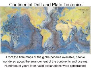
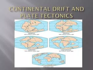
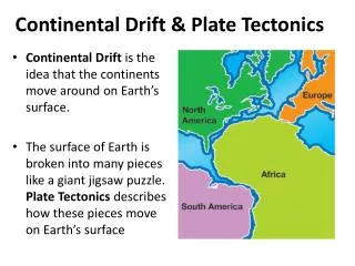
Continental Drift and Plate Tectonics. Close examination of a globe often results in the observation that most of the continents seem to fit together like a puzzle:

Continental Drift and Plate Tectonics
E N D
Presentation Transcript
Close examination of a globe often results in the observation that most of the continents seem to fit together like a puzzle: • west African coastline seems to snuggle nicely into the east coast of South America and the Caribbean sea; and a similar fit appears across the Pacific. • The fit is even more striking when the submerged continental shelves are compared rather than the coastlines.
In 1912 Alfred Wegener (1880-1930) noticed the same thing and proposed that the continents were once compressed into a single proto-continent which he called Pangaea (meaning "all lands"), and over time they have drifted apart into their current distribution. • He believed that Pangaea was intact until about 300 million years ago, when it began to break up and drift apart.
Wegener had four main pieces of evidence. First he noted the jigsaw fit of South America and Africa, especially, but also elsewhere.
Wegner also noted that fossils from South America and Africa came from the same extinct animal. Both continents back then had the same climate and vegetation, today that is not the case.
He found that on both sides of the Atlantic, mountains were the same; both in terms of age and structure.
He found that ice sheets covered parts of Africa, India, Australia and South America 250 million years ago. How could this happen in places that are so warm today?
As technology progressed two other evidences were added to Wegner’s Theory. One is called Sea Floor Spreading which will be talked about in detail in the next few slides. The other is called Magnetic Signature. Rocks that are formed in Polar regions take on a ‘Polar’ characteristic and rocks formed near the Equator take on an ‘Equatorial’ signature. Huge rocks and mountains with Equatorial signatures have been found in Polar regions and vica versa!
Sea Floor Spreading: “Advances in sonic depth recording during World War II (SONAR) led to a detailed mapping of the ocean floor. The Ocean Floor in the Mid-Atlantic was found to be spreading apart. Among the seafloor features that supported the sea-floor spreading hypothesis were: mid-oceanic ridges, deep sea trenches and island arcs” http://www.ucmp.berkeley.edu/geology/tecmech.html
The crust near the continental margins (the shoreline of the continents today) is about 200 million years old. It gets progressively younger toward the mid-Atlantic ridge, where oceanic crust is forming today (red).
14_09.JPG Scientists learned that the youngest regions of the ocean floor were along the mid-oceanic ridges, and that the age of the ocean floor increased as the distance from the ridges increased. http://www.ucmp.berkeley.edu/geology/tecmech.html
Wegener's hypothesis of continental drift lacked a geological mechanism to explain how the continents could drift across the earth's surface. It wasn’t until the 1960s that the theory of Plate Tectonics was advanced to explain how the continents could separate. A Canadian by the name of Tuzo Wilson played an important part in the development of this theory.
What Tuzo Wilson did was change the way scientists viewed the internal structure of the earth.
In order for the theory of plate tectonics to be possible. The crust of the earth called the Lithosphere was subdivided. The upper portion of the Lithosphere was called the Earth’s crust.
The Crust had to adjust itself based on density – the crust is composed of a dense material mostly found at the bottom of oceans called Oceanic Crust (basalt) • and a less dense material which we call the Continental Crust (granite). But since there is ‘more’ continental crust, it actually has more weight over the mantle. Hopefully the next diagrams will help!
Isostac(s)y One interesting property of the continental and oceanic crust is that these tectonicplates have the ability to rise and sink. This phenomenon, known as ISOSTACY, occurs because the crust floats on top of the mantle like ice cubes in water.
When the Earth's crust gains weight due to mountain building or glaciation, it deforms and sinks deeper into the mantle. If the weight is removed, the crust becomes more buoyant and floats higher in the mantle.
This process explains recent changes in the height of sea-level in coastal areas of eastern and northern Canada and Scandinavia. Some locations in these regions of the world have seen sea-level rise by as much as one meter over the last one hundred years. This rise is caused by isostatic rebound.
Both of these areas where covered by massive glacial ice sheets about 10,000 years ago. The weight of the ice sheets pushed the crust deeper into the mantle. Now that the ice is gone, these areas are slowly increasing in height to some new equilibrium level. (PhysicalGeography.net)
The main features of plate tectonics are: • The Earth's crust is broken into a series of plates (crustal plates) or pieces. • These plates are continually, moving, spreading from the center, sinking at the edges, and being regenerated. • Convection currents beneath the plates move the crustal plates in different directions. • The source of heat driving the convection currents is radioactivity deep in the Earth's mantle.
As mentioned before there are actually two types of crust: • Oceanic crust, which is thin and of course found at the bottom of the oceans. It is a compact, thin and heavy crust. • Continental crust, since it has been exposed to the atmosphere is bulkier (air) and lighter than Oceanic crust.
http://geog.ouc.bc.ca/physgeog/contents/10i.html Convection Currents power the plate movements. Convection currents rise up from the radioactive core, carrying heat to the thin crust of the earth.
The currents in the asthenosphere are generated by heat rising to the earth’s surface from the hot radioactive core • At their boundaries, the plates spread apart, converge, and slide past one another • This makes these areas the most geologically active: earthquakes and volcanoes and mountains
http://www.ngdc.noaa.gov/mgg/image/mggd.gif The Surface of the Earth without water
Click here to go to the actual site and zoom into certain areas
There are four basic Plate movements or boundaries: 1. Divergent: This is where the plates move apart, new magma wells up to the surface, forming new crust. The Mid-Atlantic ridge is a prime example. New land is created 2. Convergent: Two plates come together. Usually one of the plates subducts (goes under) the other plate, creating a Subduction zone. The crust at the leading edge of the subducting plate melts back to magma. The Pacific Rim of Fire is a good example. Land is destroyed – balance.
3. Transform Boundaries: This occurs when two plates rub against each other. This creates tremendous friction which is eventually released in the form of earthquakes. The San Andreas Fault is a Transform boundary. 4. Isostacy(Rebound): Plates moving up or down depending on the weight on the plate. Glaciers and Mountains add weight.
Hot Spots – Hawaii – An area where magma is being released and the ‘volcano’ is not depended on plate movement – an ‘ever erupting volcano’.
Oceanic-Continental CollisionResult - Volcanic mountains or arcs