Download
1 / 16
170 likes | 455 Vues
From Hypothesis to Theory. Continental drift and plate tectonics. Continental drift. In the 19th and early 20th centuries, several scientists suggested that the continental masses had been slowly but steadily moving across the Earth's surface.

E N D
From Hypothesis to Theory Continental drift and plate tectonics
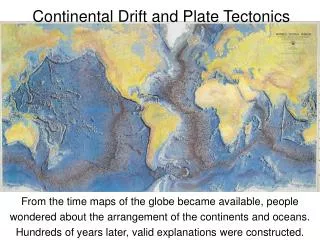
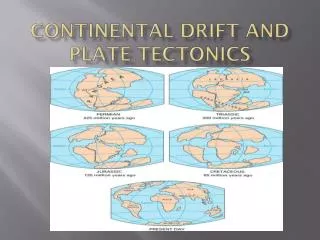
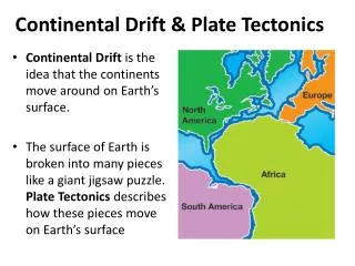
Continental drift • In the 19th and early 20th centuries, several scientists suggested that the continental masses had been slowly but steadily moving across the Earth's surface. • First proposed by A. Snider in 1858 and developed by F.B. Taylor (1908), this idea was later articulated by Alfred Wegener (1915) in his Continental Drift Hypothesis. • These early notions of continental driftwere based on the following evidence: • Some continents seem to fit together like a jigsaw puzzle. • Some geologic features, rocks and fossils found on the East coast of North and South America are similar to formations found on the West coast of Africa and Europe.
Geographic, Paleomagnetic, and Paleo geographic Evidences
Wegener’s Supercontinent – Pangaea • – later divided into Gondwana and Laurasia • – and eventually into the present continental configurations and positions.
In the late 1950s and 1960s, scientific research in oceanography, geophysics, and other Earth Sciences (aided by sonar, radioactive dating), provided further support for Continental Drift • Later, detailed mapping and study identified the process of seafloor spreading, and pointed to the Theory of Plate Tectonics
Plate tectonics • Plate tectonics is the study of the lithosphere, the outer portion of the earth consisting of the crust and part of the upper mantle. • According to the Theory ofPlate Techtonics, the lithosphere is divided into about 30lithospheric or techtonic plates –13 large • and 17 smaller – which move and interact with one another • Most plates include both continental crust and oceanic crust • These plates move very slowly over a semi-molten or plastic asthenosphere, only 2 to 5 centimeters (1-2 inches) a year • Continents and oceans move and change in shape as a result of • these plate movements • These movements also create earthquakes, volcanic activity, mountain ranges, ocean trenches and many other features.
These movements • of the lithosphere result from heat energy derived from the earth’s interior – • heat-driven convection cells in the mantle. Seafloor Spreading at an oceanic ridge produces new seafloor
In some places the plates pull away from each other (divergence), in other place they push together (convergence), and elsewhere they slide alongside each other (lateral/transform movement) • These interactions, thus, create three major plate boundary types: • 1. Divergent Plate Boundaries 2. Convergent Plate Boundaries3. Transform Plate Boundaries
DIVERGENT PLATE BOUNDARIES • Also calledConstructive Plate Margins because they create • crustal ridges and new ocean floors • Where are most divergent plate boundaries? • In the middle of oceans – • e.g., Mid-Atlantic Ridge • Occasional “oceanic” volcanoes, as in Iceland, mark divergent plate boundaries (Iceland is a volcanic island , and part of the Mid-Atlantic Ridge) • Divergent Plate Boundaries on Land – Rift Valleys • e.g., East African Rift Valleys
CONVERGENT PLATE BOUNDARIES • Often known as Destructive Zone as plate subduction takes place • How many ways can plates converge? • Ocean-Continent • Ocean-Ocean • Continent-Continent • What Goes on at Ocean-Continent Convergent Plate Boundaries? • Earthquakes occur as the ocean plate subducts • An ocean trench forms as the sea floor bends • Volcanoes form as magma erupts from the subduction zone • Mountains form as sediments are folded and faulted
What Happens at Ocean-Ocean Convergent Plate Boundary? • Earthquakes occur as one ocean plate subducts • An ocean trench forms as the sea floor bends • A volcanic island arc forms as magma rises above the subduction zone
Continent-Continent Convergent Plate Boundary Also called a Collision Zone • Mountain building occurs as the continental crust is folded and faulted • Earthquakes occur as two continents collide • NO volcanic activity – e.g., India crashes into Asia Himalayan Mountains and Tibetan Plateau
TRANSFORM PLATE BOUNDARIES San Andreas Transform Fault Plate Boundary Earthquakes only Also, Juan de Fuca Plate – subduction –volcanos on the mainland Plate boundaries
SUMMARY • Scientists now have a fairly good understanding of how the plates move and how such movements relate to earthquake activity. Most movement occurs along narrow zones between plates where the results of plate-tectonic forces are most evident. • continental drift evolved into the theory of plate tectonics • earthquakes & volcanic activity, mountain building and Folding and Faulting occurs along tectonic plate boundaries • Divergent boundaries/onstructive boundaries -- where new crust is generated as the plates pull away from each other. Rift Zones • Convergent boundaries -- where crust is destroyed as one plate dives under another. convergent boundaries: subduction zones and continental collisions, ocean to ocean convergence • Transform boundaries -- where crust is neither produced nor destroyed as the plates slide horizontally past each other.