Download
1 / 28
280 likes | 478 Vues
The Application of Global Scale Data in a Global Earthquake Disaster Alert System. LI Yigang 1 QU Guosheng 1 HUANG Jianfa 2 1,National Earthquake Response Support Service ,China 2,China Earthquake Administration ,China Liyig@263,net. Contents.

E N D
The Application of Global Scale Data in a Global Earthquake Disaster Alert System LI Yigang1 QU Guosheng1 HUANG Jianfa2 1,National Earthquake Response Support Service ,China 2,China Earthquake Administration ,China Liyig@263,net
Contents 1.Backgroud2.What is GEDAS 3.Data used by GEDAS 4.Application Samples5.Future work
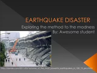
Earthquake Disaster Earthquake and earthquake induced disasters, such as the Indian Ocean tsunami in 2004 and the heavily damaged South Asia earthquake in 2005, caused huge economic loss and casualties. Earthquake disasters are becoming the mainly part of catastrophes recently. The Great South Asia Earthquake,2005
Need of Earthquake Disaster Alert Although earthquake can not be predicted exactly until now, we can get the magnitude and location for a certain earthquake event quickly after it happened based on the earthquake monitoring network. An earthquake disaster alert system can give a quick estimation of the probable impact and trigger a reasonable emergency response based on the earthquake information and local data and quick response for a disaster event can effectively reduce casualty and economic loss. GDAS(Global Disaster Alert System)and PAGER (Prompt Assessment of Global Earthquakes for Response) are such alert systems (Martin,2004,2005;USGS,2005). GDAS already gave alert assessment and rich local information to ECHO and UN since 2003 yet PAGER is still in construction.
Need of CISAR CISAR (China International Search and Rescue Team), an international disaster aid team, was established in 2001. CISAR took part in the Algeria, Iran and Pakistan earthquake rescue deployments after it was established. From the three deployments, an information support and alert software system is found to be important for quick and effective rescue. CISAR in Pakistan, 2005
Earthquake Observations Earthquake Info. Data, Models Disaster Loss Estimation GEDAS Software Map Service, News service Alert (EMAIL、SMS) CISAR& CEA The Framework of GEDAS GEDAS composes of three parts, the information acquiring sub-system, the loss estimation sub-system and the information releasing sub-system. Earthquake information can be got directly from monitoring stations and NEIC’S global earthquake list service (Finger). The information processing and loss estimation sub-system is the core of GEDAS. Based on the global database and estimation models, GEDAS can give a quick economic loss and casualties estimation and also maps around the epicenter.
NEIC Earthquake List Database(VMAP,Landscan,etc.) Earthquake information acquiring module Core Models (Economic loss estimation, casualty estimation, Alert assessment) Parameters Input Module Alert Report Creating Module Earthquake Site Map Making Module Alert releasing Module The GEDAS Software The GEDAS software is developed on ArcGIS platform. Following figure is the sketch of the modules and the workflow. The software modules include parameters input module, loss estimation and alert assessment module, alert report creating module, alert releasing module and map making module.
Disaster estimation and alert assessment model When we compute the economic loss and casualties, we must know at least a rough intensity for a certain region. We use an empirical relationship to estimate the scenario intensity for an earthquake event in GEDAS. Following is the empirical formula we use in GEDAS which derived from the empirical formula used in Western USA (Anderson, 1978; Howell, 1975; Gupta, 1976; Liu Jie, 1999; Gutenberg, 1956). I = I0 + 3.2 – 0.00106 r - 2.7lgr M =2/3 * I0 + 1 I0 is the intensity in the epicenter,M is the Richter Magnitude,r is the radius,I is intensity for a certain distance from the epicenter。
Disaster estimation and alert assessment model Referring to the GDAS alert model, we adopt following alert grade assessment formula: A = max(M - 4.5,0)0.5﹡log(max(P / 80000,0))﹡max(V,0.5)1.5 / 3 A is the alert score, M is the magnitude, P is the total population in the area where intensity is lager than six , V is the venerability index and can be got from the ECHO global need assessment report every year. The alert rank can be divided into three kinds, green, yellow and red. When the score value is smaller than 1, green alert will be released; when the score value is between 1 and 2, yellow alert will be released; when the score value is lager than 2, red alert will be released. The international relief organization should concern and prepare for deployment when the red alert is released.
Disaster estimation and alert assessment model We use a method that estimate earthquake losses based on several macroeconomic indices such as the Gross Domestic Product (GDP) and population (Chen Yong, 1995; Chen QF, 1999). This method does not require a detailed inventory database of the structures and facilities in the impact region and can get quick loss estimation. The right figure give us the relationship between intensity and the ratio of economic loss by GDP for Low, middle and high income countries separately. Based on this relationship, we can get the economic loss by using following formula: EP is the economic loss, f(I i, GDP)is the ratio of intensity I by GDP, I I is earthquake intensity, GDP is Gross Domestic Product. P T(I i)is the risk of impact of intensity in T years. For a certain earthquake, P T(I i)is always 1.
Disaster estimation and alert assessment model Compare to economic loss estimation, casualties estimation is more difficult. A reasonable relationship between earthquake intensity and casualties must think about the structure characters. Because we have not a detail structure database until now, a simple relationship for casualty estimation is used in GEDAS .
The Population Data Oak Ridge National Laboratory (ORNL)'s Global Population Project, part of a larger global database effort called LandScan, collects best available census counts (usually at province level) for each country, calculates a probability coefficient for each cell, and applies the coefficients to the census counts which are employed as control totals for appropriate areas (usually provinces). The probability coefficient is based on slope, proximity to roads, land cover, nighttime lights, and an urban density factor. Until now, Lanscan is the best population database for disaster estimation. In GEDAS, Landscan is a core database and used as base input for casualties and economic loss estimation.
The Fundamental Geographic Data Vector Map Level 0 (VMap0) is an updated and improved version of the National Imagery and Mapping Agency's (NIMA) Digital Chart of the World (DCW). VMap0 database provides worldwide coverage of vector-based geospatial data which can be viewed at 1:1,000,000 scale.
The Fundamental Geographic Data Vector Map Level 1 (VMap1) is based on 1:250,000 map scale source, and is 4 times the resolution of VMAP0. VMAP0 & VMAP1 can be read directly into ArcGIS from VPF format and used as the background for loss estimation and map making in GEDAS.
The DEM Data Other data, Such as SRTM DEM data, the GDP data, historical earthquake data, nuclear power station data, are also parts of the GEDAS database, used mainly for 3D Visualization and disaster loss estimation.
The Remote Sensing Data The GeoCover 2000 mosaics are segmented into tiles of approximately 250,000 square kilometers. Each tile covers five degrees of latitude in a UTM zone, which is 6 degrees of longitude. These mosaic images are in MrSid format and can be directly opened by using ArcGIS. The GeoCover 2000 used as the background for loss estimation and map making in GEDAS.
Sample map based on the global data 3D Map of BALAKOT North KAWAI KANSHIAN SANGARH BALAKOT SATBANI JABORI