Download
1 / 61
620 likes | 987 Vues
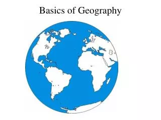
Basics of Geography. Does yours look like this?. Arctic Ocean. Europe. Asia. NA. Atlantic Ocean. Africa. Pacific Ocean. SA. Indian Ocean. Pacific Ocean. Australia. Antartica. Other Regions of the World. Pacific Rim (Ring of Fire). Middle East/ SW Asia.

E N D
Arctic Ocean Europe Asia NA Atlantic Ocean Africa Pacific Ocean SA Indian Ocean Pacific Ocean Australia Antartica
Other Regions of the World Pacific Rim (Ring of Fire) Middle East/ SW Asia Central America / Latin America Sub Sahara Africa SE Asia
“We are all bound by our geography. It helps dictate who we are and who we become”
What does geography influence? • Job • Activities • Foods • Clothing • Language • Music • Interests • Culture
Cultural Diffusion • The spread of ideas, language, religion, and technology from one place to another
Examples • Pizza • Chinese Food • Uggs • Playstation • Tim Hortons
People of Social Studies • Political Scientist – Person who studies governments and their relationships
Anthropologist • Person who studies cultures
Archaeologist • Person who studies artifacts and bones of different cultures
Economist • One who studies resources and how they are used
Geographer • One that studies geographical features and their impact on history
Types of Maps Activity: On a scrap piece of paper draw a map of the world
Political Map • Shows borders and capitals as well as major cities
Topographic Map • Shows landforms and physical features of area
Cartogram Map • Shows the size of a country or area based upon what is being measured
Latitude • Measures North and South from Equator (0 Degrees)
Longitude • Measures East and West from Prime Meridian (0 Degrees)
Hemisphere • Hemi = Half • Earth can be split 2 ways, either by using Equator or by using Prime Meridian
If Split by Equator… • We get the Northern and Southern Hemispheres
If Split by Prime Meridian • We get the Eastern and Western Hemispheres
Sources in Social studies • Primary Source – Came from the time in which the person was living • Examples: Diary, journal, autobiography • Ex. A book about Adolf Hitler written in 1940.
Secondary Source • A book or material written by someone not in that time period. • Example: Biography • Ex. Mr. Russell writing a book about Adolf Hitler
Why does cultural diffusion happen? • Trade • Communication • Forced/ Conquering
If you could live anywhere in the world, were would it be? Why?
Importance of Water • Why do we need water? • To live • To drink • To clean • For crops • For travel
Water in regard to geography • It can bring places together link them Ex. Japan, Korea and China • Or it keep them apart • Europe and America till 1400’s
Irregular Coastlines • Jagged Coastline • Good for bays, harbors, trade!!
Regular Coastline • Smooth coastline • No bays, harbors • Hinders trade
Mountain Ranges Or, the good, the bad, and the ugly
European Mountains: Not a Problem • Pyrenees divide but do not isolate • Alps - highest range, central southern Europe • Apennines, Dinaric, Balkans, Carpathians do not isolate • Kjolen Mts. • Borders: Caucasus and Urals • Irregular Coast and Navigable Rivers lessen isolation
Latin American Mountains • The Andes • Altiplano • Sierra Madres • Central Mexican Plateau
VERTICAL CLIMATE • At Sea Level, Tropical Fruits and Crops Grown • Temperate Vegetables, Coffee at higher zone • Cold Zone: Potatoes • Vertical Climate allows a variety of goods and trade among regions.
Middle East-Desert and Plateaus • TURKEY: THE ANATOLIAN PLATEAU • THE IRANIAN PLATEAU (dry) • Saudi “Empty Quarter” • Most Live Near Fertile Crescent, Nile, or Coast.
Africa:Vast Plateau, Poor Soil • ATLAS MOUNTAINS • DRAKENSBURG MOUNTAINS • RUWENZORI Mts. • GREAT RIFT VALLEY • Rivers do not unite continent
Ural Mts. Volcanoes Altai TienShan Pamirs and Hindu Kush Kunlun Himalayas Volcanoes
ISOLATION • The Andes isolate Chile from Argentina and slowed their wars • The Chinese and Indians have developed separate cultures due to their isolation
How do mountains affect people? • Isolate people – create borders • STOP CULTURAL DIFFUSION!!!! • Lack arable (Farming) land • Natural Defense (Buffer Zone) • Separate people (Balkans in Europe) • Colder due to vertical climate (lower population)