Download
1 / 11
190 likes | 767 Vues
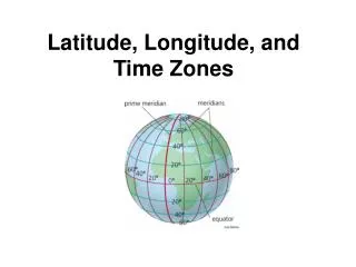
Latitude, Longitude, and Time Zones. Lat. and Long. form a grid. The point of latitude and longitude is be able to pinpoint any location on the Earth. They form a grid that should look kind of familiar…. Latitude Lines. Latitude lines: Are parallel (never meet or touch) Run East to West

E N D
Lat. and Long. form a grid • The point of latitude and longitude is be able to pinpoint any location on the Earth. • They form a grid that should look kind of familiar…
Latitude Lines • Latitude lines: • Are parallel (never meet or touch) • Run East to West • Range from 0°–90° North and South • Dumb way to remember: • Latitude = “Laddertude”
Important Lines Of Latitude • Equator • Half-way between North and South Poles • 0 ° , Neither North nor South • Tropic of Cancer • 23.5° North • Tropic of Capricorn • 23.5° South • Arctic Circle • 66.5° North • Antarctic Circle • 66.5° South Yes, these are important and we will talk about them further later on.
Longitude Lines • Longitude lines: • All meet at the North and South Poles • Run North to South • Range from 0°–180° East and West • Dumb way to remember: • Longitude = Long, tall telephone poles
Important Lines Of Longitude • Prime Meridian • Runs through Royal Observatory, Greenwich, England • 0°, neither East nor West • International Date Line • Opposite Prime Meridian • 180°, both East and West
Putting the coordinates together • Latitude, Longitude • For example: • Farmington, Utah 40°N, 111°W
The inhabited continents kind of match up with the grid. N,W - All of North America • N,E – Most of Europe, Africa, and Asia • S, W – Most of South America • S, E – All of Australia and a chunk of Africa
Time Zones • 360° ÷ 24 hours = 15° longitude for every hour of the day.
But because countries and states don’t match the longitude lines perfectly, we’ve tweaked the time zone lines to fit our needs.
West is less! • LA is three hours behind New York. • You need to be able to convert times to local time by looking at a map.