Download
1 / 63
640 likes | 856 Vues
Wind Circulations, Fronts, & Mid-Latitude Cyclones. Geostrophic Winds. Geostrophic Wind Wind flowing in a straight path, parallel to the isobars at a constant speed. Above the influence of friction (the Boundary Layer) a given parcel will accelerate toward the lower pressure due to the PGF.

E N D
Geostrophic Winds • Geostrophic Wind • Wind flowing in a straight path, parallel to the isobars at a constant speed. • Above the influence of friction (the Boundary Layer) a given parcel will accelerate toward the lower pressure due to the PGF. • Coriolis force will deflect this parcel to the right (NH) • The parcel will continue to accelerate until the PGF balances the Coriolis force and the parcel is said to be in geostrophic balance. • Assuming geostrophic flow can usually give us a good approximation of the speed and direction of the flow in the upper atmosphere. • Speed from spacing of the isobars. • Closer together the PGF increases—wind speed increases and the Coriolis force will increase to maintain geostrophic balance.
Upper Level Low Pressure System • PGF is greater than Cor. The difference b/w the PGF and Cor is “net force” • Centripetal force (due to curvature) keeps the wind blowing in a circular pattern.
Upper Level High Pressure System • Cor. > PGF • Net force is outward • Winds around a low pressure system are usually much stronger due to the increased PGF resulting from the gradient wind.
Surface Winds • Winds in the BL are strongly influenced by friction • Friction reduces the wind speed, which in turn reduces the Coriolis force • This creates an imbalance b/w the Cor and PGF, so the wind blows across the isobras toward lower pressure. • The winds near the sfc are not geostrophic due to friction • Winds near sfc blow into a low and out of a high • A way to remembering and applying the sfc and aloft balances we have discussed is through the Buys-Ballot’s Law • Stand with wind aloft to our backs, lower pressure will be to our left and higher pressure to our right in the NH • Stand with our backs to the wind, then turn clockwise 30º, lower pressure will be to our left.
Local Winds • Differential Heating • Land and Sea Breeze • Mountain Valley Breezes • Country Breezes • Chinook (Foehn) Winds • Katabatic (Fall) Winds
Land heats more rapidly, air above expands and becomes less dense and rises At about 1 km AGL the air diverges , blows toward sea, sinks and return to land at low levels. Land cools more rapidly, contracts air above. High Pressure develops over land. Land Sea Breeze Since the strongest temp gradients occur right along the ocean land boundary, the strongest winds occur at this time right along the edge of the beach and diminish inland. T contrast at night < T contrast day—stronger sea breeze Rising motion—clouds Day—land Night—ocean At the peak of the sea breeze (late afternoon), the cool ocean air be >300 m thick and extend inland 12 miles, often dropping temps as much as 9 ºF in an hour. Warm air rising and cold air sinking—Direct Thermal Circulation (DTC)
Valley Breeze • Daytime • Valley Breeze • Mountain slopes oriented toward the sun (N-S) heat more rapidly than flat land or slopes oriented away from the sun. • The air above the warmer slopes warms and expands upward, then diverges at higher altitudes
Mountain Breeze • Nighttime • Mountain Breeze • Mountain slopes cool more quickly and the cooler dense air flows from the slopes into the valleys.
General Circulation • Zonal (E-W) and Meridional (N-S) • In 1735, George Hadley described a model call the single cell model in which • Earth’s sfc is uniformly covered • The sun is always directly over the equator. (no seasonal shift of wind) • The Earth does not rotate (no Cor, only PGF) • Strong heating at the Equator causes air to expand upward, diverge toward both poles at upper-levels and sink back to the sfc before returning to the equator. This scenario is far too simplified to describe the earth’s flow, but it does describe the “Thermally Direct Circulations” of the tropics • DTC warm air rises and cool air sinks • ITC cold air rises and warm air sinks
3 Cell model • Hadley Cell • Solar heating along equator creates a zone of low pressure called the Intertropical Convergence Zone (ITCZ). • Zone of strong UVM favoring heavy rainshowers, especially in the afternoon. • Easy to identify on Satellite imagery • Migrates N or S about 10 º through seasons • Also called the Doldrums, b/c of the hot and humid conditions. • 20 -30 º lat, air begins to sink forming the Subtropical Highs • Descending air warms adiabatically (10ºC/km), suppressing cloud formation and producing desert conditions in the subtropics. • Weak pressure gradients and light winds • “Horse Latitudes” • Strongest in the winter hemisphere, when the Temp gradient is strongest
Ferrel Cell • Located b/w 30 and 60 º latitude • An ITC results from the circulation of the Hadley and Polar Cells • Sfc air moves toward the sub-polar lows at ~ 60 º latitude air rises, returns to subtropics and sinks • This creates the Westerlies in the NH, the would be southerly winds are deflected by Cor. Causing winds to become westerly • Polar Cell • b/w 60 and 90 º (the poles) • DTC since warm air rises • Sfc air moves from the Polar highs to sub-polar lows • These are called the Polar Easterlies.
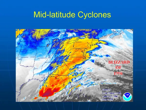
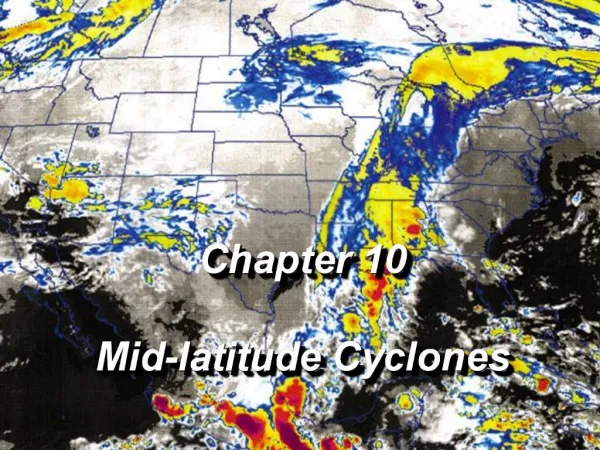
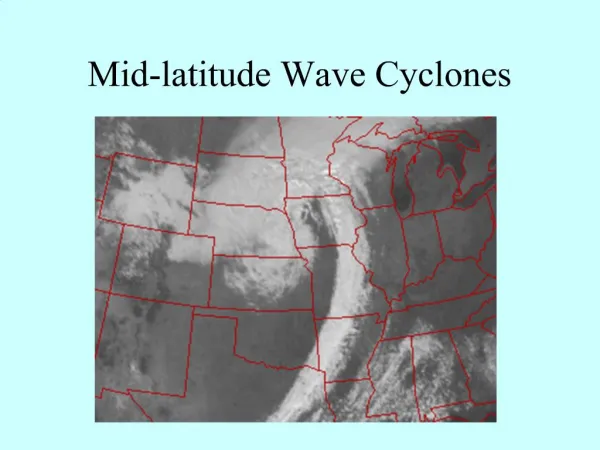
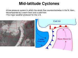
Midlatitude Cyclones • Also known as Extratropical Cyclones (ETCs) • Often form lee of the Rockies • Describe a low pressure system • Cyclonic flow … low pressure leads to sfc con which leads to UVM which in turn leads to clouds and precip • This is the principle wx-maker in the midlatitudes • Covers 1000’s of square miles, and has a lifespan of 3-10 days
Midlatitude Cyclones • Cyclogenesis—the birth of a cyclone, originates along a polar front. • Polar Front Theory—Theory of how a cyclone develops…from the Norwegians in the early 1900’s.
Before Storm • System originates as stationary front b/w cold, polar air and warmer air • The front represents a trough of low pressure with High pressure on either side • The cold air to the north and warm air to the south flow parallel to the front but in opposite directions. This type of flow sets up cyclonic wind shear.
Wave Develops • This is known as a frontal wave or incipient cyclone • Now we can identify a warm front pushing northward and a cold front pushing southward • The region of lowest pressure is called the central pressure and is located at the junction of the two fronts • As the cold air displaces the warm air upward ahead of the cold front, and as overrunning occurs ahead of the warm front, a narrow band of precip. usually occurs.
Cyclonic-circulation • Steered by winds aloft, the system typically moves E or NE and gradually becomes a fully developed open wave in 12-24 h • Central pressure much lower, several isobars fully encircle the wave’s apex • Creates a stronger cyclonic flow, as the winds swirl counterclockwise and inward toward the low’s center. • Precip wide band ahead of the warm front and along a a narrow band of the cold front. • Warm air region is called the warm sector (usually partly cloudy, but could have scattered showers if air is unstable)
Storm’s Energy Source • As the air masses try to attain equilibrium, warm air rises and cool air sinks…thereby changing potential energy to kinetic energy. • Condensation supplies energy to the system in the form of latent heat. • As the surface air converges toward the low’s center, wind speed may increase, producing an increase in kinetic energy. • NOTE: Kinetic energy is the energy of motion.
Occlusion begins • As the open wave continues to progress eastward, its central pressure continues to decrease, and the winds move more vigorously • The cold front continually inches closer to the warm front, squeezing the warm sector into a smaller area.
Occluded front developed • At this time the storm is usually the most intense, with clouds and precip covering the largest area • The point of occlusion, where the cold, warm, and occluded fronts all come together is called the triple point. • Notice: in this region, the cold and warm front resembles the open wave cyclone discussed previously. It is at the triple point where a new wave will occasionally form. This is called “secondary cyclone”, and may move eastward and intensify into a cyclonic storm.
Cyclone dissipates • Center of the intense storm will now weaken, as cold air is on both sides of the occluded front (decreases the temp. gradient) • The warm sector is still present, but is far removed from the center of the system • Without the supply of energy provided by the rising warm, moist air, the old system usually dies out and gradually dissipates.
Total lifespan can last from about 3 days to well over a week • When an ETC deepens rapidly (in excess of 24 mb in 24 h), the term explosive cyclogenesis or bomb is used. • Frontal waves that develop into huge storms are called unstable waves. These waves form suddenly, grow in size then dissipate with the entire process typically taking 3-10 days. • Other waves called stable waves remain small and never grow into giant weather producers.
Why is it that some waves develop into huge storms while other simply dissipate in a day or so? • There are many surface conditions that influence the formation of a wave, including mountain ranges and land-ocean temperature contrasts. However, the real key to the development of a wave cyclone lies in the upper-level flow in the region of high level westerlies. • So, before we can really answer the question, we need to see how the winds aloft influence the surface pressure systems.
Upper-level support for cyclogenesis • Jet Stream—Relatively strong winds concentrated within a narrow band in the atmosphere. • Jet Streak—A region of high wind speed that moves through the axis of a jet stream • Why do some waves develop into huge storms and others die out quickly?
Recall the definitions of convergence and divergence: • Convergence – The piling up of air (L) • Divergence– The spreading out of air (H)
Convergence • If we have a low pressure at both the surface and upper levels • Then we have CON at both levels • We are “piling up” air throughout the column.
We are increasing the pressure and thus getting rid of our low pressure. • But we want to make our pressure lower, not higher! We want cyclogenesis.
So how can we explain this? • When we look at a low pressure system at multiple levels, we see that the vertical axis tilts backward toward the cold air.