Fronts and Mid-latitude Cyclones
390 likes | 1.08k Vues
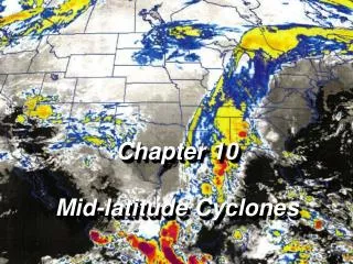
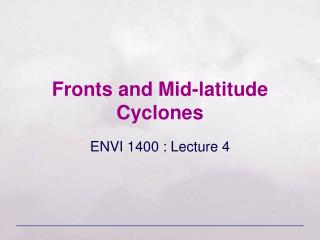
Fronts and Mid-latitude Cyclones. ENVI 1400 : Lecture 4. The boundary between two different air masses is called a front . It is a region of significant horizontal gradients in temperature or humidity. Typically 100 to 200 km wide – very sharp transitions are uncommon.

Fronts and Mid-latitude Cyclones
E N D
Presentation Transcript
Fronts and Mid-latitude Cyclones ENVI 1400 : Lecture 4
The boundary between two different air masses is called a front. It is a region of significant horizontal gradients in temperature or humidity. Typically 100 to 200 km wide – very sharp transitions are uncommon. Fronts are a dominant feature of mid-latitudes. In particular fronts associated with low pressure systems (mid-latitude cyclones, extra-tropical cyclones, depressions). The movement of fronts is responsible for much of the day-to-day variability in weather conditions. Northwest Europe receives many different air mass types, with frequent frontal passages – results in very variable weather. Fronts ENVI 1400 : Meteorology and Forecasting : lecture 4
warm air cool air movementof front Warm Front • Warm air flows up over denser cold air • Inclination of frontal surface is very shallow: 0.5 to 1 • Approach of front signalled by high cirrus or cirrostratus, cloud base lowering as surface front approaches. • Rain starts ahead of surface front, is widespread and persistent • Skies clear quickly after passage of surface front cirrus cirro-stratus warm air alto-stratus ~10 km nimbo-stratus cool air ~300 km ~500 km ENVI 1400 : Meteorology and Forecasting : lecture 4
cold air warm air movementof front Cumulo-nimbus Cold Front • Dense cold air pushes forward into warmer air, which is forced upward • Steeper than warm front: ~2 • Deep convective clouds form above surface front, heavy rain in narrow band along surface front • Behind front cloud base lifts, eventually clearing • Near the surface the cold air may surge forward, producing a very steep frontal zone ~10 km cold air warm air ~70 km ~200 km ENVI 1400 : Meteorology and Forecasting : lecture 4
Stationary Fronts cold air • There is no fundamental difference between the air masses either side of warm and cold fronts – the front is defined by the direction of motion • When the boundary between air masses does not move it is called a stationary front • Note that the wind speed is not zero – the air individual masses still move, but the boundary between them does not warm air ENVI 1400 : Meteorology and Forecasting : lecture 4
Occluded Fronts • In general cold fronts move faster than warm fronts, and may thus catch up with a warm front ahead – the result is an occluded front • There are two types of occluded fronts: warm and cold, depending on whether the air behind the cold front is warmer or cooler than the air ahead of the warm front • Cold occlusions are the more common type in the UK • Occlusion is part of the cycle of frontal development and decay within mid-latitude low pressure systems movementof front ENVI 1400 : Meteorology and Forecasting : lecture 4
Warm Occlusion • In both warm and cold occlusions, the wedge of warm air is associated with layered clouds, and frequently with precipitation • Precipitation can be heavy if warm moist air is forced up rapidly by the occlusion warm air cool air cold air ENVI 1400 : Meteorology and Forecasting : lecture 4
Cold Occlusion warm air cold air cool air ENVI 1400 : Meteorology and Forecasting : lecture 4
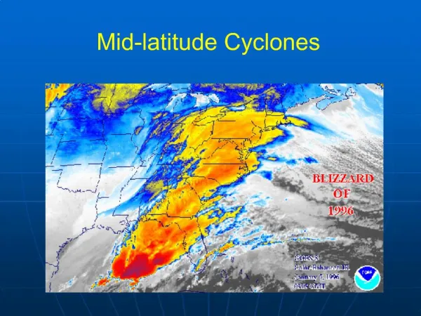
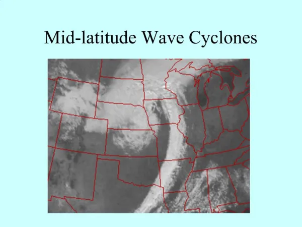
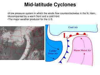
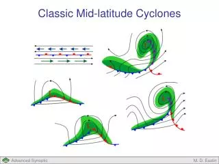
Low pressure systems are a characteristic feature of mid-latitude temperate zones They form in well defined zones associated with the polar front – which provides a strong temperature gradient – and convergent flow resulting from the global circulation Mid-latitude Cyclones 31-08-2000 ENVI 1400 : Meteorology and Forecasting : lecture 4
31-08-2000 : 1310 UTC ENVI 1400 : Meteorology and Forecasting : lecture 4
Low pressure forms at surface over polar front due to divergence aloft L • As rotation around initial low starts, a ‘wave’ develops on the polar front • Friction effects cause surface flow around low to converge • Mass balance: inward flow compensated by large-scale lifting cooling cloud formation L cloud ENVI 1400 : Meteorology and Forecasting : lecture 4
Surface low is maintained (or deepens) due to divergence aloft exceeding convergence at surface • Flow is super-geostrophic: cold sector air pushes cold front forward; warm sector air flows up warm front – warm front moves slower than cold L • Cold front overtakes warm front to form an occlusion, which works out from centre • Depression usually achieves maximum intensity 12-24 hours after the start of occlusion L ENVI 1400 : Meteorology and Forecasting : lecture 4
Low starts to weaken as inflowing air ‘fills up’ the low pressure L • Low continues to weaken, clouds break up L ENVI 1400 : Meteorology and Forecasting : lecture 4
C W ENVI 1400 : Meteorology and Forecasting : lecture 4
B W C B A C A W ENVI 1400 : Meteorology and Forecasting : lecture 4
B W Cool C B A C A W ENVI 1400 : Meteorology and Forecasting : lecture 4
C W ENVI 1400 : Meteorology and Forecasting : lecture 4
Ana-Fronts • Air is rising with respect to both frontal surfaces • Clouds are multi-layered and deep, extending throughout the troposphere tropopause warm cold cold ENVI 1400 : Meteorology and Forecasting : lecture 4
Kata-Fronts • Air aloft in the warm sector is sinking relative to the fronts • Restricts formation of medium & high-level clouds. Frontal cloud is mainly thick stratocumulus, it’s depth limited by the subsidence inversion • Precipitation is mostly light rain or drizzle. tropopause warm subsidence inversion Sc Sc cold cold ENVI 1400 : Meteorology and Forecasting : lecture 4
Ana-cold fronts may occur with kata-warm fronts, and vice-versa. Forecasting the extent of rain associated with fronts is complicated Most fronts are not ana- or kata- along whole length, or at all levels within the troposphere Some general guidance may be obtained from charts of vertical velocity (eg from NCEP) For short-term forecasts (periods of hours) & ‘nowcasts’, rainfall radar provide the best estimates of rainfall. ENVI 1400 : Meteorology and Forecasting : lecture 4
500mb surface height (dm) L L ENVI 1400 : Meteorology and Forecasting : lecture 4
A B C D L upper wind ENVI 1400 : Meteorology and Forecasting : lecture 4
Crossed-Winds Rule If an observer stands with their back to the surface wind and estimates the direction of the upper-level winds from motion of high-level clouds, they can a) estimate their position within a low pressure system, and hence b) make a rough forecast: • If upper wind from your LEFT (position A), the weather is likely to deteriorate • If upper wind from you RIGHT (position B), the weather is likely to improve • If upper wind is BEHIND or AHEAD of you (positions C, D), there is likely to be little change in the weather ENVI 1400 : Meteorology and Forecasting : lecture 4
60° 30° 0° Mid-latitudeJet Stream Polar Front Tropicaljet ENVI 1400 : Meteorology and Forecasting : lecture 4
Pacific Polar Front CanadianArctic Front Atlantic/AsiaticArctic Front 80 60 Atlantic Polar Front MediterraneanFront 30 Northern Hemisphere Winter Major Frontal Zones ENVI 1400 : Meteorology and Forecasting : lecture 4
500 hPa height (m), and temperature anomaly (C) ENVI 1400 : Meteorology and Forecasting : lecture 4