Download
1 / 2
30 likes | 140 Vues
The USGS Coalition comprises 70 organizations focused on enhancing federal investment in the U.S. Geological Survey's diverse biological, geographical, geological, and hydrological programs. With declining budgets impacting critical research and data that support natural resource management and disaster resilience, this coalition advocates for renewed funding to ensure the long-term health and prosperity of the nation. The USGS provides essential data for water management, natural hazards monitoring, and ecosystem health, directly influencing public policy and safety.

E N D
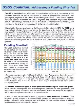
USGS Coalition:Addressing a Funding Shortfall The USGS Coalition is an alliance of 70 organizations united by a commitment to the continued vitality of the unique combination of biological, geographical, geological, and hydrological programs of the United States Geological Survey. The Coalition supports increased federal investment in USGS programs that underpin responsible natural resource stewardship, improve resilience to natural and human-induced hazards, and contribute to the long-term health, security and prosperity of the nation. Established by Congress as a branch of the Department of the Interior in 1879, the USGS has a truly national mission that extends beyond the boundaries of the nation’s public lands to encompass the homes of all citizens, through natural hazards monitoring, drinking-water studies, natural resource assessments, and other activities. The agency provides high-quality research and data to policymakers, emergency responders, resource managers, educators, and the public. The USGS has nearly 400 offices, located across the nation in every state. To aid in its interdisciplinary investigations, the USGS works with over 2,000 federal, state, local, and private agencies. Funding Shortfall The USGS budget has declined in real dollars for five consec-utive years and it would decline for a sixth year if the FY 2008 budget request is enacted. Real funding for the USGS is at its lowest level since 1996, as can be seen in the accompanying chart. The decline in funding for the USGS would have been even greater if Congress had not repeatedly restored propos-ed budget cuts. In language accompanying the FY03 spending bill, the House Appropriations Committee strongly urged the Administration “to continue to fund these critical scienceprograms in the base budget in future years.” For its part, the Senate Appropriations Committee urged the Administration “to bear in mind the expressed public support across the United States for the Survey’s programs.” The need for science in support of public policy decision-making has never been greater. USGS scientists and engineers produce knowledge and geospatial and other types of data that support water, energy and mineral resource management, wildlife and ecosystem management, and protection and prevention measures for natural disasters. In order to meet the tremendous needs of the future, more investment is needed. That investment should be used to strengthen USGS partnerships, improve monitoring networks, produce high-quality digital geospatial data and deliver the best possible science to address societal problems and inform decision makers. Version: 4-07
Essential Services for the Nation USGS water-quality studies help to protect the nation’s drinking water and fresh water resources by assessing how environmental and human factors affect the condition of our streams and ground water over time. The National Weather Service uses data from the USGS streamgage network to issue flood warnings. Other agencies use the data for assessing flood risk and drought impacts. Not only does USGS produce the topographic maps familiar to many, but it also works with partners to provide a whole new generation of high-quality, digital geospatial data products that help inform decisions by resource managers, state and local officials, and the public. Invasive species are a major environmental and economic problem. USGS researchers track the pathways of these species and study their effects on the native organisms and ecosystems. Nearly 80 million people in 39 states are at risk from destructive earthquakes. New USGS sensor arrays can produce real-time groundshaking maps and other products to help vulnerable urban areas reduce the human and economic effects of future quakes. USGS assessments of energy and mineral resources provide crucial information for environ-mentally prudent development and conservation, contributing to the nation’s economic security. USGS biologists are studying wildlife health issues like chronic wasting disease and West Nile virus. Because such diseases can also affect human populations, this research has important medical value as well. With elevated homeland security concerns, the USGS and its federal partners are developing and deploying advanced sensors to monitor vulnerable water bodies and natural resources. As the nation's mapper, USGS provides geospatial data for an array of homeland security needs. Coalition Member Organizations For more information about the USGS Coalition, please visit our web site at www.USGScoalition.org or contact co-chairs Craig Schiffries (schiffries@NCSEonline.org) or Robert Gropp (rgropp@aibs.org).