Mental Maps
Mental Maps. People and perceptions of the world. Making Sense of the World. Images of geographic space Based on: information and impressions “New Yorkers View of the World”. Mental Maps. Our perception of places are more important than reality .

Mental Maps
E N D
Presentation Transcript
Mental Maps People and perceptions of the world
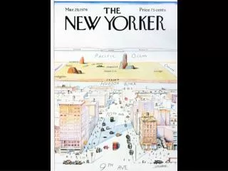
Making Sense of the World • Images of geographic space • Based on: information and impressions • “New Yorkers View of the World”
Mental Maps • Our perception of places are more important than reality. • our personal identity, provides a sense of place. • Where do mental maps come from? • Experience, hearsay, media, books, friends/family, institutions (church/school)
Mental Maps • Factors influencing perception • Distance • Distance decay: decrease knowledge with increasing distance • Who we are • Age, gender, race, ethnicity, wealth, experience • Groups • Religion, culture, nationality • Us vs. Them • Why is this important? Who cares about your mental maps?
Preference Maps • Justify each of your 5 best and worst states • What receives best results (states)? Why? • What receives worst results (states)? Why?
Mapping • Spatial representations of aspects of Earth • Cartography – art and science of mapmaking • Full of information • Ripe for interpretation
Mapping • Critical decisions • Projection – transferring a spherical surface to a flat map • Impossible to escape error • All maps lie flat, all flat maps lie
Mapping • Projection is selected to: • Minimize distortion • Area, shape, distance, or direction 2. Simplification • Omission, exaggeration, distortion 3. Aggregation – think spatial association
Mapping 4. Map Type • General reference map – political vs. physical • Topographic – contour lines of elevation
Mapping • Thematic Maps – highlight a particular feature or variable • Choropleth – shades of colors depict intensity of some variable
Mapping • Thematic Maps • Proportional Symbol – size of symbol depicts intensity or size
Mapping • Thematic Maps • Dot – number of dots depict density
Mapping • Thematic Maps • Isoline – connect points of equal value (not just topographic)
Mapping • Thematic Maps • Cartogram – space is distorted to show size of some variable http://www-personal.umich.edu/~mejn/election/2008/ http://www-personal.umich.edu/~mejn/cartograms/
Mapping 5. Scale –relationship between the map distance and actual earth distance • Large scale – small area (more detail) • Small scale – large area (less detail) • Scale is shown as: • Representative fraction • 1/24,000 or 1:24,000 • Verbal • 1 inch = 400 miles • Graphic • Scale bar
Spatial Association at Various Scales Fig. 1-13: Death rates from cancer in the US, Maryland, and Baltimore show different patterns that can identify associations with different factors.
Fires in Southern CaliforniaSource: http://earthobservatory.nasa.gov/NaturalHazards/natural_hazards_v2.php3?img_id=11799 Intro to Maps and GIS • Maps • Remote Sensing • Geographic Information Systems (GIS)
Latest World Earthquakes Map • National Atlas of the United States
The Future????? • http://www.youtube.com/watch?v=QKh1Rv0PlOQ