NOAA Arctic Ocean Observations for Climate
320 likes | 534 Vues
NOAA Arctic Research Office John Calder, Kathy Crane. NOAA Arctic Ocean Observations for Climate. Arctic GOOS Activities. 1. Arctic Sea Ice – Mass balance and dynamics - 2.Northern Bering Sea Changes 3. RUSALCA – Bering Strait Moorings

NOAA Arctic Ocean Observations for Climate
E N D
Presentation Transcript
NOAA Arctic Research Office John Calder, Kathy Crane NOAA Arctic Ocean Observations for Climate
Arctic GOOS Activities • 1. Arctic Sea Ice – Mass balance and dynamics - • 2.Northern Bering Sea Changes • 3. RUSALCA – Bering Strait Moorings • 4. Labrador Sea – pilot project Arctic Fresh Water Contributions to the Atlantic Ocean
Pacific Gateway GOAL 1 (Sea Ice Observations and Predictions)
1. Sea Ice Mass Balance andDynamics • International Arctic Buoy Program • Ice Mass Balance Buoys • IMBs colocated with NSF- and Japan- sponsored ocean buoys
International Arctic Buoy Programme (IABP)Monitoring the Arctic Since 1979
Sea Ice Mass Balance Buoys • Augment traditional International Arctic Buoy Program buoys (IABP) with new data – sea ice thickness and temperature, snow cover depth, under-ice ocean temperature (maybe radiation in future) • GOAL: Attribute changes in ice thickness to ocean or atmosphere; compute heat flux; validation points for satellite measurements
Sea Ice Summary(I. Rigor) • Wind driven changes in ice motion may be more important than variations in surface temperature. • Many of the changes in arctic climate and sea ice are related to the Arctic Oscillation, which affects sea ice on many different time scales, and the ice “remembers” these affects for many years. • This “memory” may be useful for forecasting sea ice conditions. • What is the role of the ocean in forcing these changes? Increased flow of warm water from the Atlantic and Pacific have been reported, can this contribute to the decline of sea ice? Or is this heat trapped below the cold halocline layer? • Have we passed the “tipping point”? Will ice-albedo feed back be the demise of arctic sea ice, or will prolonged low AO conditions restore thicker ice conditions? • With the decline of Arctic sea ice, have there been fundamental changes in the physical processes? Are we in a different “sea ice” regime?
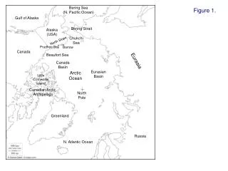
2. 3. The Bering and Chukchi Seas, Alaska and Chukotka show amplified responses to climate change. The United States and the Russian Federation are working together to monitor the change in flux into and out of the Arctic through the Bering Strait-the Pacific Gateway to the Arctic.
BERING SEA PACIFIC GATEWAY ATLANTIC GATEWAY
Northern Bering Sea • Bering Strait region shallow (<50 m); a sensitive indicator of climate change • Bering Sea shifting towards an earlier spring • Surface sea temperature increase in the 1990s vs the 1980s, tied to the Arctic Oscillation further to the north (Stabeno and Overland 2001) • Freshening in Bering Strait since 2000 (Woodgate) • Time series benthic studies indicate changes in both carbon deposition and benthic biomass since the late 1980’s (Grebmeier)
Bering Sea M2 Mooring - Temperature RecordCourtesy P. Stabeno • Vertically Averaged Temp = + 2 oC after 2000
Woodgate and Aagaard, GRL 2005 • freshening of seawater passing through Bering Strait since 2002 (above) • shelf-basin transport via advection, eddy formation, canyon transport LOTS OF • UNKNOWNS ??
Fresh Water Fluxes- pathways ? Increased Fresh Water Flow From the Arctic to the North Atlantic What are the pathways of fresh water flow across the Pacific Gateway ?
Circulation Superimposed on the Distribution of Benthic Biomass: 1970-1990 East Siberian Sea Beaufort Sea Chukchi Sea Russia Alaska Bering Sea Biomass g m-2 ?? [Dunton, Goodall, Schonberg, Grebmeier, and Maidment, 2005, DSR accepted]
2. Russian-American Long-term Census of the Arctic: RUSALCA:
RUSALCA GOALS: Take Observations Where Arctic Sea Ice Reduction is a Maximum 2. Monitor Fresh Water and Nutrient Fluxes and Transport Pathways Through the Pacific Gateway. 3. Monitor Ecosystem Indicators of Climate Change. 4. Improve Russian-U.S. Arctic Climate Science Relations
Others… Monitor Ecosystem Changes - Arctic Census of Marine Life ECOSYSTEM INDICATORS OF CLIMATE CHANGE
Rusalca Aug 04 Herald Shelf Valley
RUSSIAN-AMERICAN MOORING LOCATIONS
2003 Sign Memorandum of Understanding, Russian Academy and NOAA 2004 Khromov expeditionBering-ChukchiSeas • Census of Marine Life and exploration of the Chukchi Sea • Monitoring current fluxes through the Bering Strait and Herald Canyon • Methane exploration 2005, 2006 retrieval of mooring data Fall 2005, PI Synthesis Meeting 2007, 2008 International Polar Year RUSALCA TIME LINE
Arctic Research Office Expeditions 2004 2007- 2008 2002 20032005 NOAA Pacific Arctic Gateway exploration
RUSALCA IPY07/08 International Pan-Arctic study regions ASOF IBCAO Map
4. The Labrador Sea and Davis Strait, key sites involved in the global overturning circulation
Observations need to resolve the small scales of key currents and water masses in the northern Atlantic and to track them through annual cycles and strong decadal variability. During the winters of 2003-04 and 2004-05, four Seagliders have carried out extensive surveys of the Labrador Sea and Davis Strait. Seagliders being assembled in Nuuk, West Greenland
Warm, saline Irminger water flows north into Baffin Bay Cold Arctic water enters the Atlantic The first ocean passage section by an autonomous undersea vehicle: Davis Strait, October 2004; about 2500 profiles have been completed by two Seagliders since then. In winter 2003/4 two other gliders surveyed the Labrador Sea producing about 1500 profiles of temperature, salinity, dissolved oxygen, chlorophyll and particle scattering. Baffin current cold, low salinity flows south into Labrador Sea
A key process for climate is the salinity barrier layer that forms at the top of the Labrador Sea in spring, and controls deep convection in subsequent winter. This is visible in the next figure, as purple (cold, low salinity) water is carried off the Greenland coast by the boundary current system.
Cold shelf water (purple) streams off the Greenland shelf. Seagliders 014 and 015 are embedded in this jet Aqua & Terra satellite SST day 089 05
The Seagliders have ‘cat-scanned’ the Labrador Sea, documenting • -Arctic=>Atlantic transport west of Greenland • -wintertime deep convection (depth, geographical distribution) • -the formation of the salinity barrier layer • -the boundary current velocity and density profiles on all sides of the Sea • -remarkably fine spatial scales of the circulation • -the water-column heat storage cycle (which • constrains atmospheric observations of heat flux)
FY06 Priorities at President’s Budget $ Level • Continue Ice Mass Balance Work • Continue Bering St. mooring program • Plan for repeat “RUSALCA” during IPY • End Labrador Sea activity • Northern Bering Sea mooring in doubt