ORNL DAAC MODIS Subsetting and Visualization tools
240 likes | 428 Vues
National Aeronautics and Space Administration. ORNL DAAC MODIS Subsetting and Visualization tools. Tools and services to access subsets of MODIS data Suresh K. Santhana Vannan. www.nasa.gov . What is MODIS ?. http://svs.gsfc.nasa.gov. What is MODIS ?.

ORNL DAAC MODIS Subsetting and Visualization tools
E N D
Presentation Transcript
National Aeronautics and Space Administration ORNL DAAC MODIS Subsetting and Visualization tools Tools and services to access subsets of MODIS data Suresh K. Santhana Vannan www.nasa.gov
What is MODIS ? http://svs.gsfc.nasa.gov
What is MODIS ? • MODerateResolution Imaging Spectroradiometer • Hyper-Spectral sensor onboard two satellites (Terra and Aqua) • Terra MODIS and Aqua MODIS are viewing the entire Earth's surface every 1 to 2 days, acquiring data in 36 spectral bands, or groups of wavelengths • http://modis.gsfc.nasa.gov/
MODIS is great! but …….. Users (Field researchers) have some inconveniences :
Accessibility • Data Format • Processing Time
User community requested that we prepare MODIS Land Products in an easy-to-use format and size • To validate remote sensing products • To characterize field sites
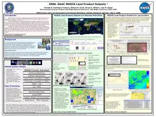
MODIS Subsets for selected field sites Data Formats Offered • ASCII – 7x7 km subsets • GeoTIFF – 25x25 km subsets Products are: 8-day, 16-day or annual composite periods 1 km, 500 m or 250 m resolution Documentation about subsets and links to detailed documentation of the MODIS products are provided 1147 field sites for MODIS Collection 5
Demo MODIS Fixed Site Subsets http://daac.ornl.gov/modisfixedsite
MODIS Subsets for any location on globe • What we offer: • MODIS land product subsets of any size (Maximum: 201x201 sq.km) • MODIS land product subsets for any time scale within the period of record for a product • Subsets are in ASCII and GeoTIFF format • MODIS Collection 5 data • How it works: • User can input the coordinates for the site or select from a picklist of sites • User chooses the areal extent and the time period • Processing of subsetted product (selection of tiles, mosaicing, generating time series data file and graphs) takes 10 to 60 minutes for most products (depends on area, time period, and product) • The tool will send an email message containing a URL where the output can be accessed
Demo MODIS Global Tool http://daac.ornl.gov/modisglobal
1975 2001
1975 2001
MODIS Web Service Get MODIS Subsets through machine to machine interaction • SOAP (Simple Object Access Protocol) based • Retrieve Subsets using: • Command line ( Perl) • Workflows (Kepler) • JAVA desktop software
Demo MODIS Web Service – JAVA client
Example Usage: What is the MODIS land cover value at 32.707072 N, -94.120474 W Perl Client
A C B Kepler- Scientific Workflow • Step A: • Provide inputs such as • Product • Band • Latitude, Longitude • Size of the subset Step B: Kepler uses the MODIS Web Service to find all dates that have MCD12Q1 (Land Cover) data for location 32.707072 N, -94.120474 W Step C: Kepler uses the MODIS Web Service to get the subsets for each available MODIS date. The subset is displayed Check in Google Maps for aerial photo of this location
Terrestrial Vegetation Phenology links to Bird Migration Phenology Extract MODIS NDVI for each bird observation location using ORNL DAAC’s MODIS Subsetting Web Service • 300,000 locations for 10 years: Web service accessed 35 million times • 500 bird species, 1 TB location-specific data (NDVI, Climate, land cover, census, etc.) Observation (Latitude, longitude, time) ORNL DAAC Latitude, Longitude of bird Observations from eBird database providing presence/absence eBird MODIS Web Service • MODIS NDVI : • 16 day composite value • 250-m spatial resolution • Data from 2000 onwards MODIS NDVI value
How is migration timing, direction, and speed of Red-eyed Vireo migration affected by climate change (early greening)? Spring Arrival Dates with Advanced Greening (14 days) Spring Arrival Dates
SignOffPage ORNL DAAC MODIS Tools