Census data and services
Census data and services. Welcome and introduction David Martin Programme Coordinator. Overview of session. Using UK census data in your research: David Martin Aggregate statistics Digital boundary data Interaction data Samples of anonymised records ONS and Scottish Longitudinal Studies.

Census data and services
E N D
Presentation Transcript
Census data and services Welcome and introduction David Martin Programme Coordinator
Overview of session • Using UK census data in your research: David Martin • Aggregate statistics • Digital boundary data • Interaction data • Samples of anonymised records • ONS and Scottish Longitudinal Studies
Using UK census data in your research Overview of datasets and services June 2006
Using UK census data in your research • Census basics • Topic coverage • Data outputs • Principal datasets • Supporting datasets • Overview of programme services • Registration and data access • How to find out more
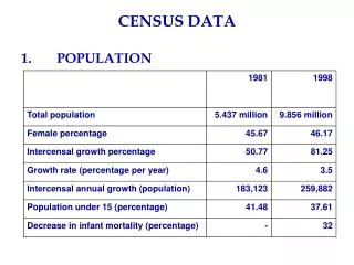
Topic coverage • Age, sex, marital status, household structure • Country of birth/ethnicity • Health/disability • Economic status • Housing, amenities • Travel to work and cars • Qualifications Source: ons.gov.uk
Data outputs • Principal datasets • Aggregate statistics • Boundaries • Interaction data • Microdata samples • Longitudinal data • Supporting datasets • Lookup tables • Metadata
Overview of programme services • Data acquisition and purchase for academic use • Single online registration service provided by Census Registration Service for online resources • Support for ONS and Scottish Longitudinal Studies • New portal service: coming soon
Census basics • Decennial data collection, most recently 29 April 2001 • Most detailed and comprehensive data source for socioeconomic research • Digital data series from modern censuses 1971 onwards • NB national differences: England and Wales; Scotland; Northern Ireland
Registration and data access • One-stop registration using Athens ID, operated jointly with ESDS • Direct access to online services • Some datasets require acceptance of additional special conditions • Don’t forget Neighbourhood Statistics, SCROL, NICA!
Registration – via Athens • Complete online registration form; • Agree to the End User Licence; • Respond to confirmation email.
How to find out more… http://census.ac.uk
Case studies • Examples of how to make use of the census resources in your research • Examples from each unit • Expert staff on hand to answer questions in this session and at our display table all day
Matching and Mixing Geographically-Referenced Data using Convert Justin Hayes, Census Dissemination Unit, University of Manchester
Case Study 1 • An educational researcher wishes to compare levels of school exclusion with characteristics of both the school’s location, and location of residence of excluded pupils, in order to identify any relationships and determine whether school or residence location is a stronger predictor of school exclusion.
Data Sources Lower Level Super Output Areas (LSOAs) Index of Multiple Deprivation 2004 Experian median household income • Postcodes • School locations • Numbers/ages of pupils • Postcodes of residence of excluded pupils 2001 Output Census Areas (OAs) 2001 Census ethnicity information NS 2001 Area Classification
Convert System • Geography matching and geographical data conversion application • LUTs between wide range of current and historical geographies • Derived from ONS postcode directories (NSPD) • New version with regular updates launching soon • Potential for direct link to deprivation scores • http://census.ac.uk/convert
Case Study 2 • Educational researcher with PCT data wishes to convert/resample to LEAs.
Conversion Methodology B A 1 C
Convert Limitations • Accuracy of PD information • Geographical allocations • Address counts • Assumptions • Addresses as population proxy • Homogeneously population-related conversions • Gender good, ethnicity not so good, cows/rainfall very bad • Quality of conversion lookups • Boundary effects and fuzziness • LUT quality measures within Convert
ConvertGrid • Integration of Convert and Casweb technologies to exploit Grid potentials • Presents data from disparate datasets/geographies and combines to users choice of geography • Open-access datasets with standard metadata • Lets users get on with the clever stuff!
Digital boundary data from UKBORDERS University of Edinburgh Data Library
Includes the results of censuses, the surveys and records gathered about individuals by health authorities, central/local government and the service sector. Normally we are dealing with aggregated data describing a group of observations grouped by a particular Geography. Socioeconomic Data
Geographical space can be subdivided in many different ways and for many different purposes for the reporting of socioeconomic data (census or otherwise). Reporting geographies form intangible boundaries which differ from natural geographic features. Differences between epochs of geographies – between the 1971, 1981, 1991 and 2001 census years for example. Which Geography?
United Kingdom Boundary Outline and Reference Database for Education and Research Study. Based at EDINA, University of Edinburgh. Boundary data delivered through UKBORDERS since 1996. Provides services for supporting geographic data for learning, teaching and research. UKBORDERS
Web based delivery of digitised boundary datasets and associated look-up-tables of the UK. Main group of datasets correspond to the various levels of the 1981, 1991 and 2001 census geography. Important associated datasets include current and historical postcode directories from ONS. Why use UKBORDERS?
A key benefit is convenient access to “ready-made” datasets. • Full on-line help is provided. Off-line support is provided through the EDINA Geo Data Services support team. • Dedicated facilities provide access to these datasets, either pre-packaged or through a dynamic user driven interface.
Researchers interested in the spatial visualisation and analysis of census statistics and other socioeconomic datasets linked to census output geographies. Who uses UKBORDERS? • Population • Deprivation • Employment • Education • Health • Housing • Crime
Researcher is interested in patterns of deprivation and access to public health services in Oxford. Has claimant data from DWP and deprivation data from ODPM reported using the lower layer Super Output Area geography. Map data using boundaries
Wants to visualise the data geographically and look for interesting patterns. • Through UKBORDERS, the researcher can download Lower layer SOA boundary data for Oxford.
DWP Claimant Data. Provides a count of Jobseekers allowance claimants broken down by 3 age bands. ODPM deprivation data. Index of Multiple Deprivation made up from 7 weighted indices including income; employment; health & disability; education, skills & training; barriers to housing & services; crime and, living environment. Background
Both datasets are reported using the Lower Super Output Area (LSOA) geography. Designed by ONS to improve the reporting of small area statistics. • Built from groups of Output Areas, LSOA`s have a minimum population of 1000, a mean population of 1500 and are constrained by the boundaries of census Standard Table wards.
Login to UKBORDERS requires Registration with Census Registration Service and an Athens username.
Use UKBORDERS Boundary Data Selector to extract LSOA boundary data for Oxford only.
Select Output Format. Preview Data.
Having explored the patterns in the datasets, the researcher chooses to focus on the patterns of deprivation within Oxford and explore possible associations between deprivation and access to Health care. Researcher obtains from Oxford Primary Care Trust a list of NHS dentists in the city, each of which has a postcode as part of its address. Use postcode directories
Through UKBORDERS, the researcher can download postcode directories supplied by ONS • Directories provide a grid reference for each postcode and allocates each postcode to a range of geographies • Holds Live and terminated postcodes • Current version known as the National Statistics Postcode Directory (NSPD) and is released quarterly
Use NSPD to assign LSOA codes and grid reference to each dental practice using its postcode. Associate ODPM Index of Multiple Deprivation Scores using the LSOA code.
Maintain the viability and operation of existing UKBORDERS facilities Add new datasets Improved access to postcode directories Enhanced metadata and support materials Support the proposed Census Portal Developments during 2006-11
Interaction data from the Census Interaction Data Unit (CIDS) Universities of Leeds and St Andrews
What are Census interaction data? • Interaction data include: - Special Migration Statistics (SMS) - Special Workplace Statistics (SWS) - Special Travel Statistics (STS) • Flow data involving two geographies: origins and destinations • Extremely rich data sets for use by researchers and practitioners • Especially valuable because of lack of alternative data sources, especially below district scale