Download
1 / 21
210 likes | 355 Vues
Watershed Modeling for Improved Surface Water Predictions in the Tennessee and Mobile Bay Basins. Jairo N. Diaz, William H. McAnally, James L. Martin, John H. Cartwright, Vladimir J. Alarcon, and Mary L. Tagert Alabama Water Resources Conference Orange Beach, September 6-7, 2007.

E N D
Watershed Modeling for Improved Surface Water Predictions in the Tennessee and Mobile Bay Basins Jairo N. Diaz, William H. McAnally, James L. Martin, John H. Cartwright, Vladimir J. Alarcon, and Mary L. Tagert Alabama Water Resources Conference Orange Beach, September 6-7, 2007
Objectives • Introduce the Northern Gulf Institute (NGI) • Introduce three projects focused on Mobile river basin • Report on the progress and conclusions of these projects to date • Solicit input on basin data and resource management needs
Northern Gulf Institute (NGI) A NOAA-sponsored cooperative institute led by Mississippi State University in partnership with: University of Southern Mississippi Louisiana State University Florida State University Dauphin Island Sea Lab http://www.ngi.msstate.edu/
Northern Gulf Institute (NGI) • NGI Themes • Ecosystem Management • Geospatial Data Integration and Visualization • Climate Change & Variability • Coastal Hazards • Common to Themes • Water Quantity • Water Quality • Ecosystem Responses • Tools Needed • Basin-wide Perspective
Three 1st Year Projects Focused on Mobile Basin • Watershed Modeling Improvements to Enhance Coastal Ecosystems • Spatial Technology and High Performance Computing - Improving Water Quality Prediction • Modeling Mobile Bay Sediments and Pollutants with New Technologies
Study Area Mobile Bay Courtesy of Tim Wool EPA Region 4
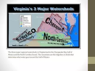
Mobile Bay • Drains waters in 4 states: AL, GA, MS, TN with 7 major subbasins and 32 8-Digit HUCs • 6th largest basin in the U.S. (based on area) at 44,000 square miles; 350 miles long with a maximum width of 250 miles • Shipping channel in the middle of the bay and heavy barge traffic into Mobile, AL and upstream transport of coal and goods
People • Investigators • Civil and Environmental Engineering (4) • Biology (1) • Landscape and Geospatial (3) • USACE Vicksburg (3) • Graduate Students • Civil and Environmental Engineering (4 master, 2 Ph.D.) • Computer Sciences (1 master) • Biology (1 Ph.D.)
Watershed Modeling Improvements to Enhance Coastal Ecosystems • Goal • Decision support for resource management agencies improved watershed-wide • Investigate additional data products to improve the performance of the BASINS models • Plan • Fully engage Mobile Basin stakeholders and technology partners • Water budget for the Basin • Validated watershed models using standard models and inputs
Watershed Modeling Improvements to Enhance Coastal Ecosystems Stakeholder and Resource Agency Meetings • May 2007 • EPA and Tetra Tech modelers (HSPF, WASP, and EFDC) • June 2007 • Deputy Director of the Mobile Bay National Estuary Program • Technical Interagency Committee (TIC) Members for The Alabama Coastal Area Management Program • USACE modelers (WMS, GSSHA, SMS, CEQUAL-W2) • EPA and Tetra Tech modelers (Grid Based Mercury Model - GBMM) • Dauphin Island Sea Lab modelers (EFDC) • USACE Regional Sediment Management Team • July 2007 • Big Black/Tenn Tom Basin Coordinator for MDEQ • August 2007 • Alabama Department of Environmental Quality
Watershed Modeling Improvements to Enhance Coastal Ecosystems • Hydrologic Simulation Program FORTRAN (HSPF) • Conceptual model (water balance + empirical relations) • Lumped parameter model (homogeneous areas) • Water quantity and water quality simulations • Event and continuous simulations • Supported by EPA • Evaluated in U.S., Europe, Africa, Caribbean, Asia
Watershed Modeling Improvements to Enhance Coastal Ecosystems • Study areas: • Luxapallila Creek Watershed • Mobile River Watershed
Luxapallila Creek Watershed • Summary of the Luxapallila Creek simulation studies using the HSPF model • Hydrology and water quality (sediments, DO, WT) • Land use databases (MODIS, GIRAS, NLCD) • Rainfall databases (gauge and radar) • Topographic databases (300 vs 30 mts resolution) • Parameter uncertainty (Monte Carlo simulation and Probabilistic Point Estimate Methods – Harr and Li) • Parameter sensitivity (Monte Carlo Simulation) • Channel property variability (RF1 and USGS data) • Potential evapotranspiration data sensitivity
Luxapallila Creek Watershed • Application of the Gridded Surface Subsurface Hydrologic Analysis (GSSHA) model physically base distributed-parameter model supported by the USACE Grid Grid Land Use Soils DEM
Mobile River Watershed 54 Sub-basin delineation and USGS flow stations Rainfall spatial distribution using Thiessen polygons
GIS HPC 3-D Models Spatial Technology and High Performance Computing - Improving Water Quality Prediction GIS Goal: Develop and demonstrate advanced technologies to predict water quality impacts of management actions. HPC 3-D Models Integrated Solutions Graphics by GRI, NASA, and USACE
Modeling Mobile Bay Sediments and Pollutants with New Technologies Goal: A management model for sediment, mercury and DDT in Mobile Bay and Tributaries. NASA Image Clay flocs (above) sorb contaminants.
GIS HPC 3-D Models Summing Up • Three interlocking projects on Mobile Basin • Goal: Contribute to better water resources management in the basin • More and better observed data • Improved models • Improved data analysis and visualization • System-wide perspective
Solicit Input • Basin data needs? • Resource management needs?
Contact Information William H. McAnally mcanally@cee.msstate.edu James L. Martin jmartin@cee.msstate.edu Jairo N. Diaz jd216@msstate.edu http://www.ngi.msstate.edu/