Download

1 / 44
440 likes | 457 Vues
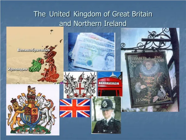
The United Kingdom of Great Britain and Northern Ireland-Geography. www.zlinskedumy.cz.

E N D
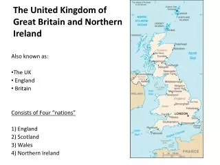
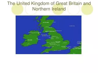
The United Kingdomof Great Britain and NorthernIreland-Geography • www.zlinskedumy.cz
Great Britain has a total area ofonly121,000sqmiles, yetwithinthissmall area isfound a great variety ofscenerywhichisdirectlyrelated to theunderlying rock. Rock type affects not onlyscenery but alsotheoccupations and livelihoodoftheinhabitantsofan area – thesoil and vegetation. Thissimplifiedgeological map of Great Britainisanapproximateguide to therocksthatunderliethelandscape in differentpartsofthe country. Obrázek 2 Uk topo en Obrázek 1 Geology Map UK
Obrázek 3 Climatevariable TheBritishclimateisneither very hot nor very cold. Itisdescribed as beingtemperate. Itfrequentlychangesbut has fewextremes. Theaveragetemperature in winteris 7°Celsius. The most common, orprevailing, windsblowfromthesouth-west. Thenorth-westcoastisthestormiest area oftheBritishIsles. Theforceofthewindismeasuredaccording to the Beaufort scale. Thiswasinvented in 1806 as a formofshorthandfor sailors, who had to recordweatherconditions in a ship´s log.
H Obrázek 4 CatbellsNorthern Ascent, Lake District Catbells is a fell in the English Lake District in the county of Cumbria. It has a modest height of 451 metres,but despite this it is one of the most popular fells in the area. It is situated on the western shore of Derwent Water , 3 miles of the busy tourist town of Keswick.
H Lakeof the big peak is a natural lake in the county of Powys, Wales. Obrázek 5 Llyny FanFawr
H H Obrázek 6 Cloughaheather Obrázek 7 ScafellPike Scafell Pike is one of a horseshoe of high fells, open to the south, surrounding the head of Eskdale, Cumbria. It stands on the western side of the cirque with Scafell to the south and Great End to the north. This ridge forms the watershed between Eskdale and Wasdale lyinginto the west. Scafell Pike consists of igneous rock dating from the Ordovician geologically part of the BorrowdaleVolcanics. The summit plateau of Scafell Pikeis covered with shattered rock debris which provides the highest altitude example of a summit boulder field in England.
H H Obrázek 9 Highlands - lowlands Obrázek 8 Scotland
While Snowdonia contains a mix of volcanic rocks and sedimentary rocks of Cambrian and Ordovician age, the mountains of South Wales are predominantlyDevonian age Old Red Sandstone and Carboniferous Limestone and similarly aged sandstones. H Obrázek 10 ViewoverLlynLlygadRheidol
H Obrázek 11 The Skiddaw massif, town of Keswick and Derwentwaterseen from Walla Crag. The crag is the terminalverticalcliff on a short ridge running north -west from BleaberryFell.
H H Obrázek 12-13 DartmoorNationalPark
H Obrázek 14 The Exmoor landscape with the native ExmoorPony. Moorland is a type of habitat, in the temperate grasslands, savannas, shrublands biome, found in upland areas, characterised by low-growing vegetation on acidic soils and heavy fog. Moorland nowadays generally means uncultivated hill land -Dartmoor in South West England,but the Old English mōr also refers to low-lying wetlands (such as Sedgemoor). Moorrefers to highland, high rainfall zones, whereas heath refers to lowland zones which are likely to be the result of human activity.
H Obrázek 15 WestSedgemoornaturereserve
H Obrázek 16 EppingForest, southofHigh Beach, Essex
Forestcovered most ofBritainuntilpeopleclearedit to make roomforsettlements and farmland. Later, woodwas in demandforbuilding and forfuel, especially in industries such as iron smelting. Thisresulted in theneedforwidespread re-plantingoftreesduringthe 18th and 19thcenturies.
Coniferousforestsprovideshelterforshyanimals, such as pine martens and deer. Birds such as goldcrests, crossbills and long-earedowlslive in these woods. WoodyCones
They bear fruit such as nuts, pods and berries. Broad – leaved woods are a mixtureof many different species of trees. But in a mature deciduous wood there are usuallymore trees of one species than another. They are also a mixture of many differenttypes of plants. Each type grows at a different level and forms a distinct layer (mosses,fungi grow close to the earth and make a ground layer, flowers and ferns reach up fartherand form the next layer, then come the bushes in what is called the shrub layer. The leafytops of the tall trees form the canopy.
T F Quiz
Results F ( 121,000 ) F ( cold ) T F ( western ) T F ( Ordovician ) F ( chain ) F ( Devonian ) F ( vertical ) F ( acidic ) T T
Obrázek 17 Carpet of Bluebells in Bucknell Woods, Whittlewood Forest, Abthorpe Parish, between Abthorpe and Silverstone in South Northamptonshire H Obrázek 18 CommonRedstart Obrázek 19 RedSquirrel H
Obrázek 20 WhiteAdmiral Obrázek 23 Ptarmigan Obrázek 48 Kingfisher H
H Obrázek 21 GoldenEagle Obrázek 22 Osprey
ThelargestofBritain´snativewildanimalsistheRedDeer, foundmainly in northern Scotland and lessfrequently in partsofEngland and NorthernIreland. Itsnormal habitat isdeciduouswoodland, but in Scotland it has adapted to life on theuplandmoors. Obrázek 24 ScottishWildcat H Obrázek 25 RedDeer
Obrázek 27 Yewtree Obrázek 28 Taxusbaccata shoot withcones Obrázek 26 Scots pine /Pinussylvestris/
Obrázek 29 Wistman'sWood, a remnant of ancient oak Quercusrobur woodland on Dartmoor, Devon, England IfBritain´scountrysidewereallowed to revertto forest, oakswouldeventuallybethedominant treeacross most ofthe country. Obrázek 30 Warwickshire, BagintonOaktree
H Obrázek 32 TheRiver Tweed from Mertoun House, near St Boswells Britain has a highrainfall. Itis not surprising, there are many lakesand rivers. Thelakes are mostly in theuplandsareaswhererainclouds breakoverthemountains. There are in Wales, Scotland and theNorthWestofEngland, part ofwhichiscalledTheLakeDistrict. Thesameareas are the source of many ofour major rivers such as theSevern (England), theWye (Wales) and theForthand theClyde(Scotland). Obrázek 31 Major riversof England
H Obrázek 33 River Avon in Stratford-upon-Avon, Warwickshire, England
Obrázek 34 Islands in Loch Lomond. Looking south west from Inchcaillochalong the lineof the Highland Boundary Fault to Torrinch,Creinch, Inchmurrin and Ben Bowie. H Obrázek 35 Loch Ness
Obrázek 36 A marsh along the edge of a small river. Obrázek 38 A male Yellow-headed Blackbird Obrázek 39 Water Lily A little insect hides under the petal of the water lily.
H Obrázek 40 DurdleDoor is a natural limestone arch on the Jurassic Coast near Lulworth in Dorset, England.
H Obrázek 41 Puffin with spread wings (FarneIslands, England) Obrázek 42 A pair of Guillemots One of the very striking seabirds to be found on the Farne Islands.
TheFarneIslandswereacquired by theNational Trust in 1925.They are teemingwithbirdlife and are especiallywell-knownforpuffins. A greysealcolonyusestheislandsas a breedingground. In autumnthefemalecomesasbore to givebirth to a single white-coatedpup. Obrázek 43 FarneIslands Sea cliffs on thesouthern tip of Inner Farne Obrázek 44 Greyseal
The Giant's Causewayis an area of about 40,000 interlocking basalt columns, the result of an ancient volcanic eruption. It is located in County Antrim on the northeast coast of Northern Ireland, about three miles (4.8 km) northeast of the town of Bushmills. Obrázek 47 Giant's Causeway and Causeway Coast protect area
Obrázek 45 WhiteCliffsof Dover H Obrázek 46 A view of the White Cliffs of Dover
CROSSWORDS 3 6 8 9
ACROSS 3A – a very largebirdyoucansee very well, iteatssmallbirds and animals 6G – a smallbright blue birdwith a long peak, thatcatchesfish in rivers 8H – aninsectwith a long, thin body and fourcolouredbrightly wings 9C – a NorthAtlanticseabirdwith a largebrightly-colouredbeak DOWN B3 – a largebirdthatkillsothercreaturesfor food, thateatsfish D3 – an animal with long legs, thateatsgrass, leaves and can run fast, most male deerhaveantlers H1 – a birdwith a fat body and feathers on itslegs, found in mountainareasand in Articregions M6 – a grey animal withshortfurthatlives in and nearthesea and eatsfish, has no legs, swimswiththehelpofshortflat arms - flippers P1 – a smallredorgrey animal with a long thicktailthatlives in treesand eatsnuts
Obrázek 1 Geology Map UK ALEXD. wikipedia.org [online]. unknown [cit. 25.7.2012]. Dostupný pod licencí creativecommons na WWW: <http://en.wikipedia.org/wiki/File:Geology_Map_UK.svg>. Obrázek 2 Uktopoen BLOOD, Captain. wikipedia.org [online]. 7 July 2006 [cit. 25.7.2012]. Dostupný pod licencí CreativeCommons na WWW: <http://en.wikipedia.org/wiki/File:Uk_topo_en.jpg>. Obrázek 3 Climatevariable UNKNOWN. metoffice.gov.uk [online]. [cit. 25.7.2012]. Dostupnýna WWW: <http://www.metoffice.gov.uk/climate/uk/anomacts/>. Obrázek 4 Catbells Northern Ascent, Lake District DILIFF. wikipedia.org [online]. 25 June 2009 [cit. 26.7.2012]. Dostupný pod licencí CreativeCommons na WWW: <http://en.wikipedia.org/wiki/File:Catbells_Northern_Ascent,_Lake_District_-_June_2009.jpg>. Obrázek 5 Llyn y FanFawr GRUAR, David. wikipedia.org [online]. 25 January 2004 [cit. 26.7.2012]. Dostupný pod licencí CreativeCommons na WWW: <http://en.wikipedia.org/wiki/File:Llyn_y_Fan_Fawr.jpg>. Obrázek 6 Cloughaheather BLISCO. wikipedia.org [online]. 1 September 2005 [cit. 26.7.2012]. Dostupný pod licencí CreativeCommons na WWW: <http://en.wikipedia.org/wiki/File:Clougha_heather.jpg>. Obrázek 7 ScafellPike THORNEH. wikipedia.org [online]. 13 October 2006 [cit. 26.7.2012]. Dostupný pod licencí public domain na WWW: <http://en.wikipedia.org/wiki/File:Scafell_Pike.JPG>. Obrázek 8 Scotland (Location) Named (HR) RAB-K. wikipedia.org [online]. 1 November 2007 [cit. 26.7.2012]. Dostupný pod licencí WikimediaCommons na WWW: <http://en.wikipedia.org/wiki/File:Scotland_(Location)_Named_(HR).png>. Obrázek 9 The highlands and lowlands of Scotland JROCKLEY. wikipedia.org [online]. 10 August 2007 [cit. 26.7.2012]. Dostupný pod licencí public domain. na WWW: <http://en.wikipedia.org/wiki/File:Highlands_lowlands.png>.
Obrázek 10 ViewoverLlynLlygadRheidol LUCAS, John. wikipedia.org [online]. 31 May 2011 [cit. 26.7.2012]. Dostupný pod licencí CreativeCommons na WWW: <http://en.wikipedia.org/wiki/File:Geograph-2436823-by-John-Lucas.jpg>. Obrázek 11 The Skiddaw massif, town of Keswick and Derwent Water seen fromWallaCragDILIFF. wikipedia.org [online]. 16 October 2009 [cit. 26.7.2012]. Dostupný pod licencí CreativeCommons na WWW: <http://en.wikipedia.org/wiki/File:Keswick_Panorama_-_Oct_2009.jpg>. Obrázek 12 View up the River Meavy towards Sharpitor and Leather Tor HERBY. wikipedia.org [online]. 29 September 2008 [cit. 26.7.2012]. Dostupný pod licencí CreativeCommons na WWW: <http://en.wikipedia.org/wiki/File:View_to_Sharpitor_from_Meavy.JPG>. Obrázek 13 Map of Dartmoor National ParkNILFANION. wikipedia.org [online]. 26 September 2010 [cit. 26.7.2012]. Dostupný pod licencí CreativeCommons na WWW: <http://en.wikipedia.org/wiki/File:Dartmoor_National_Park_UK_location_map.svg>. Obrázek 14 The Exmoor landscape with the native Exmoor Pony. WSUPERMAIN2. wikipedia.org [online]. 12 December 2009 [cit. 26.7.2012]. Dostupný pod licencí CreativeCommons na WWW: <http://en.wikipedia.org/wiki/File:Exmoors_on_Exmoor.jpg>. Obrázek 15 West Sedgemoor nature reserve MCKENNA, Chris. wikipedia.org [online]. 18 February 2005 [cit. 26.7.2012]. Dostupný pod licencí CreativeCommons na WWW: <http://en.wikipedia.org/wiki/File:RSPB_West_Sedgemoor_nature_reserve_-_lake.jpg>. Obrázek 16 Epping Forest DILIFF. wikipedia.org [online]. 27th of September 2008 [cit. 26.7.2012]. Dostupný pod licencí Creative Commons na WWW: <http://en.wikipedia.org/wiki/File:Epping_Forest_Centenary_Walk_2_-_Sept_2008.jpg>. Obrázek 17 Carpet of Bluebells in Bucknell Woods, Whittlewood Forest, Abthorpe Parish, between Abthorpe and Silverstone in SouthNorthamptonshire ROBBINS, Ben. wikipedia.org [online]. 10 May 2006 [cit. 26.7.2012]. Dostupný pod licencí Creative Commons na WWW: <http://en.wikipedia.org/wiki/File:Bucknell_Wood_-_Bluebells.jpg>.
Obrázek 18 CommonRedstart DEBOT. wikipedia.org [online]. 6 July 2005 [cit. 26.7.2012]. Dostupný pod licencí CreativeCommons na WWW: <http://en.wikipedia.org/wiki/File:Gekraagde_Roodstaart_20040627.JPG>. Obrázek 19 Redsquirrel WHIPPEY, Paul. wikipedia.org [online]. 11 March 2012 [cit. 26.7.2012]. Dostupný pod licencí CreativeCommons na WWW: <http://en.wikipedia.org/wiki/File:Redsquirrel_eating_2012.jpg>. Obrázek 20 WhiteAdmiral D. GORDON E. ROBERTSON. wikipedia.org [online]. 16 July 2009 [cit. 26.7.2012]. Dostupný pod licencí CreativeCommons na WWW: <http://en.wikipedia.org/wiki/File:White_Admiral.jpg>. Obrázek 21 GoldenEagle HISGETT, Tony. wikipedia.org [online]. 7 August 2011 [cit. 26.7.2012]. Dostupný pod licencí CreativeCommons na WWW: <http://en.wikipedia.org/wiki/File:Golden_Eagle_in_flight_-_5.jpg>. Obrázek 22 Osprey EDMONDS, Matt. wikipedia.org [online]. Spring 2007 [cit. 26.7.2012]. Dostupný pod licencí CreativeCommons na WWW: <http://en.wikipedia.org/wiki/File:Osprey_prepare_to_mate.jpg>. Obrázek 23 Ptarmigan HAUGSETH, Jan Frode. wikipedia.org [online]. 28 May 2010 [cit. 26.7.2012]. Dostupný pod licencí CreativeCommons na WWW: <http://en.wikipedia.org/wiki/File:Rock_Ptarmigan_(Lagopus_Muta).jpg>. Obrázek 24 ScottishWildcat TRIMMING, Peter. wikipedia.org [online]. December 27, 2011 [cit. 26.7.2012]. Dostupný pod licencí CreativeCommons na WWW: <http://en.wikipedia.org/wiki/File:Wildcat_at_British_Wildlife_Centre.jpg>. Obrázek 25 RedDeer EBBESEN, Bill. wikipedia.org [online]. 26 September 2009 [cit. 27.7.2012]. Dostupný pod licencí CreativeCommons na WWW: <http://en.wikipedia.org/wiki/File:Red_deer_stag_2009_denmark.jpg>. Obrázek 26 Scots Pine BRUCE. wikipedia.org [online]. 6 January 2008 [cit. 27.7.2012]. Dostupný pod licencí CreativeCommons na WWW: <http://en.wikipedia.org/wiki/File:Pinus_sylvestris_Glenmuick.jpg>.
Obrázek 27 Yewtree SANNSE. wikipedia.org [online]. 2003-09-10 [cit. 27.7.2012]. Dostupný pod licencí CreativeCommons na WWW: <http://en.wikipedia.org/wiki/File:English_Yew_600.jpg>. Obrázek 28 Taxusbaccata MPF. wikipedia.org [online]. 31 October 2005 [cit. 27.7.2012]. Dostupný pod licencí CreativeCommons na WWW: <http://en.wikipedia.org/wiki/File:TXbaccata.jpg>. Obrázek 29 Wistman'sWood in winter, a remnant of ancient oak Quercusrobur woodland on Dartmoor, Devon, England ALEX, Jane. wikipedia.org [online]. 25 March 2005 [cit. 27.7.2012]. Dostupný pod licencí CreativeCommons na WWW: <http://en.wikipedia.org/wiki/File:Wistman%27s_Wood_in_winter.jpg>. Obrázek 30 Warwickshire, BagintonOaktree SNOWMANRADIO. wikipedia.org [online]. 2006-07-24 [cit. 27.7.2012]. Dostupný pod licencí CreativeCommons na WWW: <http://en.wikipedia.org/wiki/File:Baginton_oak_tree_july06.JPG>. Obrázek 31 Great RiversofEnglandUNKNOWN. wikipedia.org [online]. 10 October 2010 [cit. 27.7.2012]. Dostupný pod licencí CreativeCommons na WWW: <http://en.wikipedia.org/wiki/File:Major.rivers.of.England.jpg>. Obrázek32 River Tweed from MertounHouse, near St Boswells WALLEY, Jean. wikipedia.org [online]. 17 May 2003 [cit. 27.7.2012]. Dostupný pod licencí CreativeCommons na WWW: <http://en.wikipedia.org/wiki/File:River_Tweed_from_Mertoun_House.jpg>. Obrázek 33 River Avon in Stratford-upon-Avon, Warwickshire,England UNKNOWN. wikipedia.org [online]. 14 April 2007 [cit. 27.7.2012]. Dostupný pod licencí CreativeCommons na WWW: <http://en.wikipedia.org/wiki/File:River_avon_stratford_14a07.JPG>. Obrázek 34 Islands in Loch Lomond.Lookingsouth west from Inchcailloch along the line of the Highland Boundary Fault to Torrinch,Creinch, Inchmurrin and Ben Bowie. THOMAS, Donald. wikipedia.org [online]. 6 May 2006 [cit. 27.7.2012]. Dostupný pod licencí CreativeCommonsAttribution-ShareAlike 2.0 Generic na WWW: <http://en.wikipedia.org/wiki/File:Lomond_islands.jpg>.
Obrázek 35 Urquhart Bay and Loch Ness viewed from Grant's Tower at Urquhart Castle. KINGSLEY, Gregory J. wikipedia.org [online]. 30 June 2009 [cit. 27.7.2012]. Dostupný pod licencí CreativeCommonsAttribution-ShareAlike 3.0 Unported na WWW: <http://en.wikipedia.org/wiki/File:Loch_Ness_from_Urquhart_Castle_-_kingsley_-_30-JUN-09.jpg>. Obrázek 36 A marsh along the edge of a small river. ÓÐINN. wikipedia.org [online]. 9 September 2007 [cit. 27.7.2012]. Dostupný pod licencí CreativeCommonsAttribution-ShareAlike 3.0 Unported na WWW: <http://en.wikipedia.org/wiki/File:Wye_Marsh_panorama1.jpg>. Obrázek 37 Wetland profile for Great Lakes DOUGLAS A. WILCOX, TODD A. THOMPSON, ROBERT K. BOOTH, AND J.R. NICHOLAS. wikipedia.org [online]. 3 June 2012 [cit. 27.7.2012]. Dostupný pod licencí public domain na WWW: <http://en.wikipedia.org/wiki/File:USGS_image_cropped.jpg>. Obrázek 38 A male Yellow-headedBlackbirdVERNON, Alan. wikipedia.org [online]. 7 July 2011 [cit. 27.7.2012]. Dostupný pod licencí CreativeCommonsAttribution 2.0 Generic na WWW: <http://en.wikipedia.org/wiki/File:Xanthocephalus_xanthocephalus_-100_Mile_House,_British_Columbia,_Canada_-male-8.jpg>. Obrázek 39 Water Lily A little insect hides under the petal of the water lily. ATHERTON, Kay. wikipedia.org [online]. 29 June 2007 [cit. 27.7.2012]. Dostupný pod licencí Creative Commons na WWW: <http://en.wikipedia.org/wiki/File:Water_Lily_-_geograph.org.uk_-_483063.jpg>. Obrázek 41 Puffin with spread wings (Farne Islands, England) MECKEL, Matthias. wikipedia.org [online]. 3. června 2006 [cit. 27.7.2012]. Dostupný pod licencí CreativeCommons na WWW: <http://cs.wikipedia.org/wiki/Soubor:Puffins-fi2.jpg>. Obrázek 40 Durdle Door is a natural limestone arch on the Jurassic Coast near Lulworth in Dorset, England. BLAZE, Saffron. wikipedia.org [online]. unknown [cit. 27.7.2012]. Dostupný pod licencí CreativeCommons na WWW: <http://en.wikipedia.org/wiki/File:Durdle_Door_Overview.jpg>.
Obrázek 42 A pair of Guillemots One of the very striking seabirds to be found on the Farne Islands. HADDINGTON, John. wikipedia.org [online]. 22 May 2004 [cit. 27.7.2012]. Dostupný pod licencí CreativeCommons na WWW: <http://commons.wikimedia.org/wiki/File:A_pair_of_Guillemots_-_geograph.org.uk_-_772390.jpg>. Obrázek 43 Farne Islands Sea cliffs on thesouthern tip of Inner Farne MYKURA, Nigel. wikipedia.org [online]. 26 August 2008 [cit. 27.7.2012]. Dostupný pod licencí CreativeCommons na WWW: <http://commons.wikimedia.org/wiki/File:Farne_Islands_-_geograph.org.uk_-_946630.jpg>. Obrázek 44 Greyseal WŁODARCZYK, Mateusz. wikipedia.org [online]. 2010 [cit. 27.7.2012]. Dostupný pod licencí CreativeCommons na WWW: <http://en.wikipedia.org/wiki/File:Foka_szara_mateusz_wlodarczyk.jpg>. Obrázek 45 White Cliffs of Dover EINSTEIN, Norman. wikipedia.org [online]. December 19, 2005 [cit. 27.7.2012]. Dostupný pod licencí CreativeCommons na WWW: <http://en.wikipedia.org/wiki/File:White_Cliffs_of_Dover_map.png>. Obrázek 46 A view of the White Cliffs of Dover HTTP://WWW.FLICKR.COM/PEOPLE/FANNY. wikipedia.org [online]. September 7. 2004 [cit. 27.7.2012]. Dostupný pod licencí CreativeCommons na WWW: <http://en.wikipedia.org/wiki/File:White_cliffs_of_dover_09_2004.jpg>. Obrázek 47 Giant's Causeway and Causeway Coast protected area CODE. wikipedia.org [online]. May 28, 2005 [cit. 27.7.2012]. Dostupný pod licencí Creative Commons na WWW: <http://en.wikipedia.org/wiki/File:Causeway-code_poet-4.jpg>. Obrázek 48 Kingfisher VAIDYANATHAN, Ravi. wikipedia.org [online]. 12 September 2002 [cit. 27.7.2012]. Dostupný pod licencí CreativeCommons na WWW: <http://en.wikipedia.org/wiki/File:Alcedo_atthis_3494.jpg>.