Download
1 / 16
160 likes | 173 Vues
Explore soil erosion effects and estimation using spatial data in West Java, Indonesia. Utilize soil erosion models, image processing, and GIS tools to study factors affecting soil loss per unit area. Case study examines factors leading to high soil erosion rates in the region.

E N D
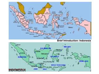
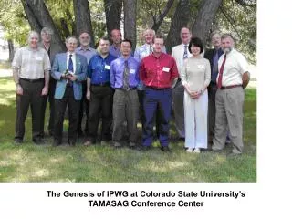
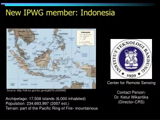
New IPWG member: Indonesia Center for Remote Sensing Contact Person: Dr. Ketut Wikantika (Director-CRS) Source: http://hdl.loc.gov/loc.gmd/g8070.ct000982 Archipelago: 17,508 islands (6,000 inhabited) Population: 234,693,997 (2007 est.) Terrain: part of the Pacific Ring of Fire- mountainous
Estimation and evaluation of soil erosion using multitemporal spatial data Case Study: West Java Indonesia Darmawan S.1, Hirano A.2,Uchida S.2, Hadi F.1, Wikantika K.1 1)Center for Remote Sensing, Institut Teknologi Bandung, CRS-ITB Indonesia 2)Japan International Center for Agricultural Sciences (JIRCAS), Tsukuba Japan
Backgrounds • Soil functions : • - Regulating and partitioning water and solute flow • - Filtering, buffering, degrading, immobilizing, and detoxifying • - Sustaining plant and animal life below and above the surface • - Storing and cycling nutrients • Soil erosion effects : • Soil degradation, pollution, agricultural production and regional income • Soil erosion models • USLE, RUSLE-1, RUSLE-2, MOSES, EUROSEM… • Image processing and GIS tools • Commercial & open source (GRASS)
Study Area West Java Province: 3.709.528 ha, 37 million people (most populated in Indonesia) and 30 % people in agriculture Study Area 104048-108048 Le 5050’-7050’ Ls Java sea Jakarta Banten Paddy field Bandung Environmental disaster Tea plantation Central java Hindia Ocean
USLE Mathematic model A = R x K x Ls x C x P A is the computed soil loss per unit area R the rainfall and runoff factor. K the soil erodibility factor. Ls the slope length-gradient factor. C the crop/vegetation and management factor. P the support practice factor. Soil erosion tolerance rate (Robert P., 2000)
C factor 9 2 5 2 6 2 5 2 7 8 2 4 6 8 3 2 P factor 2 5 2 6 2 5 2 4 5 6 9 3 2 2 5 7 4 2 7 9 3 6 7 1 7 8 2 4 6 8 3 4 2 1 2 3 5 6 2 8 6 7 2 4 5 5 6 5 K factor 7 4 5 9 2 4 7 6 3 7 8 2 4 6 8 5 5 2 5 2 6 2 5 2 9 6 7 8 6 3 2 1 3 R factor 8 4 5 6 3 4 5 3 7 8 2 4 6 8 3 2 2 5 2 6 2 5 2 5 5 6 9 3 2 2 5 7 Ls factor 1 8 7 9 3 6 7 4 7 8 2 4 6 8 3 6 3 1 9 4 5 9 8 8 5 3 7 8 8 7 3 3 Method GIS and Image Processing USLE Model Land Use Soil Soil erosion = CxPxKxRxLs Rainfall Soil erosion map in 1994, 1997, 2001, 2005 Slope
Slope in total area 0 - 16 = 81 % 16 - 30 = 13 % 30 - 100 = 6 % DEM and Slope Elevation in meter Elevation in total area Java sea 0 - 500 = 64 % 500 - 1500 = 33 % 1500 - 3000 = 3 % Jakarta Java sea Hindia ocean Slope in % In this case slope length 30 m Hindia ocean
Rainfall 1994 1997 2001 2005 Java sea Average Rainfall mm/year 1997 2001 1994 2005 Hindia ocean Rainfall mm/year Extreme Average rainfall 1994
Soil erosion in 1994,1997,2001,2005 based on river basin Ton/900m2/year Higher soil erosion in 2001 Cisadane Cimandiri Citarum Cisanggarung Cimandur Ciujung Cibareno
Conclusion • Soil erosion was very high in Cibareno River basin because changes from forest to agricultural area and agricultural area to palawija fields • Higher soil erosion in 2001 because of rainfall extreme • In Majalengka and Kuningan, low rainfall will cause high soil erosion because of steep slope
More important issue … Clean and drinking water
Dirty water kills Source: http://www.unwater.org/worldwaterday/flashindex.html
Sources of clean and drinking water • Poor water resources management ≈ poor land storage • More dependent on rain
Indonesia’s involvement the IPWG: • Good rain estimate is important for Indonesia: • Use of satellite estimates • Challenges in remote sensing estimates: • Land v. Water (17,508 islands) • Terrain (mountainous) • Land use (for instance, paddy field) • CRS-ITB can contribute on validation with around 4,000 rain gauges (manual)