Download

1 / 30
310 likes | 334 Vues
Sharing hydrologic data and supporting hydrologic science and education in the US. Provides web services, tools, and standards for accessing and analyzing hydrologic data.

E N D
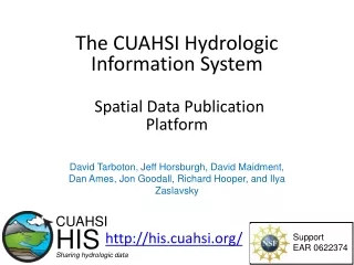
The CUAHSI Hydrologic Information System http://his.cuahsi.org/ CUAHSI HIS Sharing hydrologic data Support EAR 0622374
Consortium of Universities for the Advancement of Hydrologic Science, Inc. • 110 US University members • 6 affiliate members • 12 International affiliate members • (as of March 2009) An organization representing more than one hundred United States universities, receives support from the National Science Foundation to develop infrastructure and services for the advancement of hydrologic science and education in the U.S. http://www.cuahsi.org/
HIS Team and Collaborators • University of Texas at Austin – David Maidment (PI), Tim Whiteaker, Ernest To, Bryan Enslein, Kate Marney • San Diego Supercomputer Center – Ilya Zaslavsky, David Valentine, Tom Whitenack • Utah State University – David Tarboton, Jeff Horsburgh, Kim Schreuders, Justin Berger • Drexel University – Michael Piasecki • University of South Carolina – Jon Goodall, Tony Castronova • Idaho State University – Dan Ames, Ted Dunsford, TevaVeluppillai • CUAHSI Program Office – Rick Hooper, David Kirschtel, Conrad Matiuk, YooriChoi • WATERS Network – Testbed Data Managers • HIS Standing Committee • USGS– Bob Hirsch, David Briar, Scott McFarlane • NCDC– Rich Baldwin
What is HIS • The CUAHSI Hydrologic Information System (HIS) provides web services, tools, standards and procedures that enhance access to more and better data for hydrologic analysis. http://his.cuahsi.org Water quantity Water quality Precipitation Meteorology
return request return request NAWQA request return request return NAM-12 return request NWIS return request return request return request NARR Data Searching – What we used to have to do Searching each data source separately Michael Piasecki Drexel University
NAWQA NWIS NARR ODM What HIS enables Searching all data sources collectively GetValues GetValues GetValues GetValues generic request GetValues GetValues Michael Piasecki Drexel University GetValues GetValues
Base Station Computer(s) Telemetry Network Sensors CUAHSI Water Data Services System Discovery Analysis Access Query, Visualize, and Edit data using ODM Tools Hydroseek GIS Matlab Splus R IDL HIS Desktop HydroExcel Java C++ VB ODM Database Service Registry Hydrotagger WaterML Streaming Data Loader GetSites GetSiteInfo GetVariableInfo GetValues Excel, text HIS Central Harvester USGS NWIS Water Metadata Catalog WaterOneFlow Web Service ODM Data Loader EPA STORET NCDC Others
Hydroseekhttp://www.hydroseek.org Bora Beran, Drexel Supports search by location and type of data across multiple observation networks including NWIS and Storet
Desktop Hydrologic Information System Harvesting and analyzing data from web services Observations GIS Models Climate Remote Sensing Goal for 2009
Direct analysis from your favorite analysis environment. e.g. Excel
Direct analysis from your favorite analysis environment. e.g. Matlab % create NWIS Class and an instance of the class createClassFromWsdl('http://river.sdsc.edu/wateroneflow/NWIS/DailyValues.asmx?WSDL'); WS = NWISDailyValues; % GetValues to get the data siteid='NWIS:02087500'; bdate='2002-09-30T00:00:00'; edate='2006-10-16T00:00:00'; variable='NWIS:00060'; valuesxml=GetValues(WS,siteid,variable,bdate,edate,'');
Set of query functions ReturnsdatainWaterML WaterML and WaterOneFlow WaterML is an XML language for communicating water data WaterOneFlow is a set of web services based on WaterML Slide from David Valentine
“When” Time, T t A data value vi (s,t) “Where” s Space, S Vi “What” Variables, V What are the basic attributes to be associated with each single data value and how can these best be organized? Groundwater levels Streamflow Precipitation & Climate Soil moisture data Flux tower data Water Quality • Observations Data Model (ODM) • A relational database at the single observation level (atomic model) • Stores observation data made at points • Metadata for unambiguous interpretation • Traceable heritage from raw measurements to usable information • Standard format for data sharing • Cross dimension retrieval and analysis
CUAHSI Observations Data Model http://his.cuahsi.org/odmdatabases.html Horsburgh, J. S., D. G. Tarboton, D. R. Maidment and I. Zaslavsky, (2008), A Relational Model for Environmental and Water Resources Data, Water Resour. Res., 44: W05406, doi:10.1029/2007WR006392.
Site Attributes SiteCode, e.g. NWIS:10109000 SiteName, e.g. Logan River Near Logan, UT Latitude, Longitude Geographic coordinates of site LatLongDatum Spatial reference system of latitude and longitude Elevation_m Elevation of the site VerticalDatum Datum of the site elevation Local X, Local Y Local coordinates of site LocalProjection Spatial reference system of local coordinates PosAccuracy_m Positional Accuracy State, e.g. Utah County, e.g. Cache
Feature Observations Data Model Waterbody Watershed HydroPoint HydroID HydroID HydroID HydroCode HydroCode HydroCode * FType DrainID FType Name AreaSqKm Name AreaSqKm JunctionID JunctionID JunctionID NextDownID * * ComplexEdgeFeature SimpleJunctionFeature HydroEdge HydroJunction HydroJunction HydroJunction 1 HydroID 1 HydroID HydroID HydroID HydroCode HydroCode HydroCode HydroCode ReachCode NextDownID NextDownID NextDownID Name LengthDown LengthDown LengthDown LengthKm HydroNetwork DrainArea DrainArea DrainArea LengthDown FType FType FType FlowDir Enabled Enabled Enabled FType AncillaryRole AncillaryRole AncillaryRole EdgeType Enabled EdgeType Flowline Shoreline Independent of, but can be coupled to Geographic Representation Arc Hydro or NHD+ ODM 1 Sites 1 SiteID SiteCode SiteName OR Latitude Longitude … CouplingTable 1 SiteID HydroID 1
Loading data into ODM ODM Data Loader • Interactive ODM Data Loader • Loads data from spreadsheets and comma separated tables in simple format • Streaming Data Loader (SDL) • Loads data from datalogger files on a prescribed schedule • Interactive configuration • SQL Server Integration Services (SSIS) • Microsoft application accompanying SQL Server useful for programming complex loading or data management functions SDL SSIS
Dynamic controlled vocabulary moderation system ODM Data Manager ODM Website ODM Tools ODM Controlled Vocabulary Moderator XML Master ODM Controlled Vocabulary Local ODM Database ODM Controlled Vocabulary Web Services Local Server http://his.cuahsi.org/mastercvreg.html From Jeff Horsburgh
HIS Central • Publishers • Register a data service • Users • Find a data service • Supported by • Metadata Catalog http://hiscentral.cuahsi.org
HydroTagger Ontology: A hierarchy of concepts Each Variable in your data is connected to a corresponding Concept
National Web Services implemented to date • NWIS daily value data (e.g., daily average streamflow) • NWIS groundwater data • NWIS real time data • NWIS instantaneous irregular data (field measurements, water quality) • ORNL Daymet Meteorological model • NCEP North American Mesoscale (NAM) Weather Research and Forecasting (WRF) model • EPA STORET water quality data • NASA MODIS Atmospheric data derived from remote sensing
HIS Implementation in WATERS Network Information System National Hydrologic Information Server San Diego Supercomputer Center • 11 WATERS Network test bed projects • 16 ODM instances (some test beds have more than one ODM instance) • Data from 1246 sites, of these, 167 sites are operated by WATERS investigators
Prototype Texas HIS • TWDB is supporting a small project at University of Texas to start building a prototype Texas Hydrologic Information System HIS servers at data sources (State agencies, River authorities, Water Districts, Cities, Counties….) Web Services Texas Hydrologic Information Server (at TNRIS) Texas Observations Catalogs and some state water datasets
Intermountain Constellation of Experimental WATERsheds (ICEWATER) The Inland Northwest Research Alliance (INRA) Water Research Consortium is establishing a HIS Network to share experimental watershed data to address regional water resources challenges
How CUAHSI works with agencies • Establish an agreement with the agency • Identify the scope of the service • Translatethe semantics of the service to WaterML • Include agency personnel in OGC/WMO Hydrology Domain Working Group • Develop a first draft of the web service • Perform unit testing, over a series of validation cases • Harvest an observations metadata catalog for agency data • Develop a procedure for catalog updates • Document and register the water data service at HISCentral • Review and test the service together with the agency, for possible approval as “operational”
Demonstrations • Hydroseek: http://www.hydroseek.net • Little Bear River: http://littlebearriver.usu.edu/ • HydroExcel
Ideas for SWSI application • HIS Server display of SWSI • ODM of SWSI • Input data used to calculate SWSI • Calculated SWSI values • WaterML based Web Services • Web Map/Feature/Raster geospatial data services • Map based display of SWSI
Ideas for SWSI application • SWSI viewer as HIS Desktop/Mapwindow plugin • Access SWSI calculation inputs • Access published SWSI values • Access published SWSI maps • Compute and display custom SWSI products
Conclusions • Data Storage in an Observations Data Model (ODM) • Data Access through internet-based Water Data Services using a consistent data language, called WaterML • Data Indexing through a National Water Metadata Catalog • Data Discovery through federated map and thematic keyword search system The combination of these capabilities creates a common window on water observations data for the United States unlike any that has existed before.