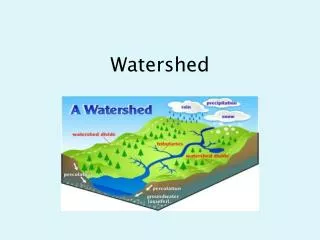
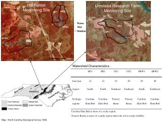
Watershed Characteristics.
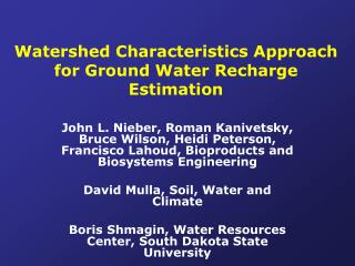
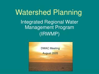
Umstead Research Farm Monitoring Site. #. %. #. 0. 0. 0.1. 0.1. 0.2. 0.2. 0.3. 0.3. 0.4. 0.4. Kilometers. Kilometers. Hill Forest Monitoring Site. HF2. HF1. #. #. #. Flume. UF2. Weir. HFW1. ". ". Weather. %. UF1. %. HFW2. ". Watershed Characteristics.

Watershed Characteristics.
E N D
Presentation Transcript
Umstead Research Farm Monitoring Site # % # 0 0 0.1 0.1 0.2 0.2 0.3 0.3 0.4 0.4 Kilometers Kilometers Hill Forest Monitoring Site HF2 HF1 # # # Flume UF2 Weir HFW1 " " Weather % UF1 % HFW2 " Watershed Characteristics. Carolina Slate Belt is more of a rocky region. Triassic Basins is more of a sandy region where the soil is easily erodible. Map: North Carolina Geological Survey 1998.
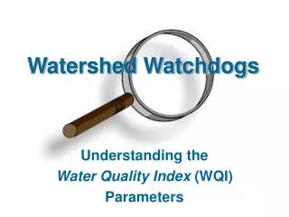
0 0.1 0.2 0.3 0.4 Kilometers Hill Forest Monitoring Site Intake tube Well Temperature sensor (under water) HF2 HF1 Sigma Sampler # # HFW1 " % HFW2 " Stilling Well, Pressure transducer H-Flume Best Management Practice (BMP) Effectiveness Monitoring Watershed Study
Red area: land with low-gradients soils forming seasonal perched water tables above expansive clay layers. Dreps and James