Petroleum System
Petroleum System. Sedimentary Basin.


Petroleum System
E N D
Presentation Transcript
Sedimentary Basin Sedimentary Basin studies investigate the geohistory of a particular basin, including its tectonic history and associated structural styles, the depositional history and resulting stratigraphic section, the burial history of the sediments, and thermal history of the strata (modified from Magoon and Dow, 1994). Definition after Magoon and Dow (1994): Sedimentary Basin is a depression filled with sedimentary rocks.
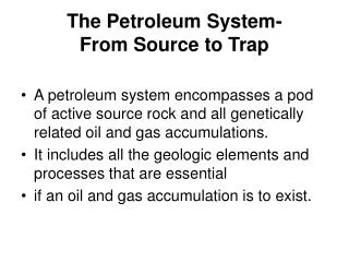
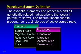
Petroleum System Petroleum System studies characterize and model the genetic relationship between an active source rock and the resulting oil and gas accumulation (modified from Magoon and Dow, 1994).
Petroleum Play Petroleum Play analysis describes the present-day geologic similarity that characterizes a play such as a a particular petroleum trap or reservoir (modified from Magoon and Dow, 1994).
Prospect Prospect evaluations detail the individual petroleum trap or reservoir, including economic aspects and technology considerations (modified from Magoon and Dow, 1994).
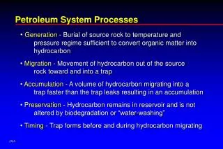
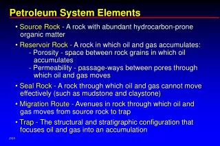
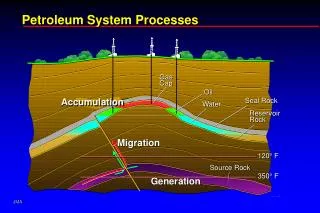
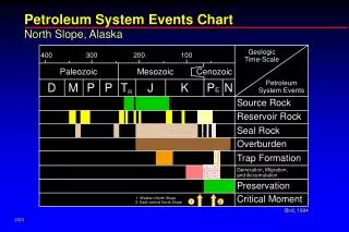
Elements of Petroleum System (Magoon and Dow (1994) Geographic Extent: Includes the Active Source Rock and Petroleum Shows, Seeps, and Discoveries Encompassed in a Defined Area at a Certain Time (Critical Moment). Illustrated with Plan Map. Stratigraphic Extent and Components: Underburden, Source, Reservoir, Seal, and Overburden Rocks. Illustrated with Geologic Cross Section. Temporal Events: Sediment Deposition (Source, Reservoir, Seal, and Overburden Rocks), Trap Formation, Oil and Gas Generation, Expulsion, Migration, Accumulation, and Preservation, and Critical Moment. Shown with Events Chart.
Critical Moment Critical Moment is the point in time that best depicts the generation-expulsion-migration-accumulation of most hydrocarbons in a given petroleum system (modified from Magoon and Dow, 1994).
Upper Jurassic Petroleum Systems of the World (Klemme, 1994) Fourteen petroleum systems, as recognized, contain one fourth of the world’s discovered oil and gas. Oxfordian Smackover Formation of the Gulf of Mexico Ranks Fourth as to the Estimated Hydrocarbons Available in the Classification of UJ Petroleum Systems.
Upper Jurassic Smackover Petroleum System (Claypool and Mancini, 1989) Source of Much of Discovered Oil and Gas in Gulf of Mexico. Source for Smackover Reservoirs. Source for Other Upper Jurassic Reservoirs. Source for Some Lower and Upper Cretaceous Reservoirs. Potential Source for Some Paleogene Reservoirs.
Events Chart for Smackover Petroleum System in the NLSB From Mancini et al., 2008
Smackover Chromatogram Lake Como Field, Jasper Co, MS. From Mancini et al., 2001
Hosston Chromatogram Free State Field, Jones Co, MS. From Mancini et al., 2001
Washita Chromatogram Main Pass 253 Field, OCS From Mancini et al., 2001
Biomarkers Histogram Steranes From Mancini et al., 2001
Biomarkers Histogram Terpanes From Mancini et al., 2001
Tertiary, UK, and UJ Source Rocks in MS and LA (Sassen, 1990) Paleogene Shale Beds Are Source Rocks in Southern LA and Offshore GOM. Upper Cretaceous Tuscaloosa Shale Beds Are Source Rocks in MS and LA. Upper Jurassic Smackover Lime Mudstone Beds Are Source Rocks in MS and LA.
Paleogene Source Rocks in TX (Rowan et al., 2007) Paleocene-Eocene Wilcox Shale Beds Are Source Rocks in TX. Kerogen in Wilcox Shale Beds Generated Oil and Gas
Petroleum System Characterization and Modeling Burial or Geohistory Plot or Chart Oil and Gas Expulsion Plot Hydrocarbon Migration Pathway Sections
Gulf Coast Interior Salt Basins Gulf Coast Interior Salt Basins From Mancini and Puckett, 2005
North Louisiana Salt Basin, Cross Sections and Well Locations From Mancini et al., 2008
NLSB Basin Cross Section C-C’ N S From Mancini et al., 2008 VE: 29X
Burial History Profile, NLSB Downdip From Li, 2006
NLSB Smackover Source Rocks Lower and Middle Lime Mudstone Beds Measured present-day TOC average of 0.58% Calculated original TOC average of 1.00% Measured present-day TOC high range of 8.42% Microbial-amorphous kerogen type Range of Ro of <0.5 to >2.6%
Model Calibration %Ro (measured) From Li, 2006
Thermal Maturation History Profile, NLSB Downdip From Li, 2006
Hydrocarbon Expulsion Plot, NLSB Downdip From Li, 2006
SMK Hydrocarbon Expulsion Peak Oil Peak Gas From Li, 2006
Bossier Hydrocarbon Expulsion Mancini et al., 2008
Location Map of Seismic Sections From Mancini et al., 2008
Geologic Model, NW-SE Section From Mancini et al., 2008
SMK Oil Migration, NW-SE Section From Mancini et al., 2008
SMK Gas Migration, NW-SE Section From Mancini et al., 2008
NLSB Thermal Maturation From Mancini et al., 2008