Large Igneous Provinces
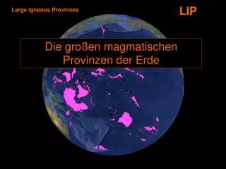
LIP. Large Igneous Provinces. Die großen magmatischen Provinzen der Erde. LIP´s of the World. Siberian traps 250 Ma (Late Permian). Viluy traps 360 Ma (Late Devonian). Emeishan traps 258 Ma (Late Permian). Columbia River Basalt 16 Ma (Early Miocene). Deccan traps

Large Igneous Provinces
E N D
Presentation Transcript
LIP Large Igneous Provinces Die großen magmatischen Provinzen der Erde
LIP´s of the World Siberian traps 250 Ma (Late Permian) Viluy traps 360 Ma (Late Devonian) Emeishan traps 258 Ma (Late Permian) Columbia River Basalt 16 Ma (Early Miocene) Deccan traps 65 Ma (Late Cretaceous) Ethiopian and Yemen traps, 30 Ma (Oligocene) Madagascar traps, ~ 90 Ma (Mid Cretaceous) Karoo and Ferrar traps, 184 Ma (Mid Jurassic) Parana and Etendeka traps, 132 Ma (Early Cretaceous) North Atlantic Tertiary Volcanic Province, 55 & 60 Ma (Paleocene) Continental Flood Basalts Trap
LIP Large Igneous Provinces Ontong–Java plateau 117, 98, 93 Ma (Mid-Late Cretaceous Ozeanische Plateaus
LIP Large Igneous Provinces
Spuren von heißen Flecken Crough 1983
Hot Spot Track – der Hawaii – Emperor - Seamount Kette 81 Ma Emperor Inselkette Hawaii Inselkette heute aktiv Spur wird kontinuierlich jünger in Richtung Hawaii Hawaii Karte der magnetischen Anomalien Spur ist unabhängig von der Bewegung der Lithosphärenplatten – kreuzt die magnetischen Anomalien der ozeanischen Kruste
Columbia River Basalt 16 Ma (Early Miocene) & Yellowstone Hot Spot Fig. 1. Map showing the distribution of the Colombia River basalts (CRBs) and track of the Yellowstone hot spot. According to Pierce and Morgan [14], activity of the CRBs started due to the arrival of gigantic plume head of the Yellowstone hot spot ca. 16 Ma ago. The plume hit the boundary between Oregon, Idaho and Nevada where rhyolite volcanism occurred due to crustal anatexsis. Much of the basalt magmas, however, traveled to the north through 1000 km long NS rift system and drained at the boundary between Washington and Oregon States. Simplified after fig. 1 of Pierce and Morgan [14].
Scoring hotspots: the Plume and Plate paradigms Don L. Anderson Seismological Laboratory, Caltech, Pasadena, California 91125,USA dla@gps. caltech. edu
Klassisches Modell: Mantelkonvektion betrifft den gesamten Mantel
Alternative: zwei unabhängige Konvektionssysteme im unteren und oberen Mantel
Tomographisches Modell des Erdmantels 1350 km Tiefe p-Wellen s-Wellen van der Hilst et al. 1997
Miner Petrol DOI 10.1007/s00710-009-0068-z Structure, mineralogy and dynamics of the lowermost mantle Reidar G. Trønnes
Beispiel für Konvektionsmodell im Oberen Mantel Cartoon illustrating the architecture of the subduction zones and the related pattern of mantle convection in the Mediterranean region. C Faccenna & TW Becker Nature465, 602-605 (2010) doi:10.1038/nature09064
Noch eine Alternative Holden & Vogt 1977
Ein streng mechanistischer Ansatz für Plattentektonik Holden & Vogt 1977