Point-surface interpolation
Point-surface interpolation. Day 1: point-surface interpolation. Principles Tobler’s First Law of Geography and spatial interpolation Classification of methods Common methods Thiessen polygons Trend surfaces Inverse distance weighting (IDW) TINs Geostatistical Analyst in ArcMap.

Point-surface interpolation
E N D
Presentation Transcript
Day 1: point-surface interpolation • Principles • Tobler’s First Law of Geography and spatial interpolation • Classification of methods • Common methods • Thiessen polygons • Trend surfaces • Inverse distance weighting (IDW) • TINs • Geostatistical Analyst in ArcMap
Principles of interpolation • Tobler’s First Law of Geography • “Everything is related to everything else, but near things are more related than distant things.”1 • Spatial interpolation • The procedure of estimating the values of properties at unsampled sites within an area covered by existing observations • important in addressing problem of data availability • quick fix for partial data coverage • interpolation of point data to raster surface • role of filling in the gaps between observations 1W. R. Tobler, (1970) "A computer movie simulating urban growth in the Detroit region". Economic Geography, 46(2): 234-240.
Classification of methods • Methods of spatial interpolation: • many different methods available • e.g. Thiessen polygons • e.g. Inverse distance weighting • classification according to: • exact or approximate • deterministic or stochastic • local or global • gradual or abrupt • Remember! Tobler’s First Law of Geography
Common methods • Thiessen polygons • Gradual or abrupt? • Exact or approximate? • Local or global? • Deterministic or stochastic?
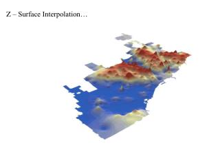
Common methods • Trend surfaces • Gradual or abrupt? • Exact or approximate? • Local or global? • Deterministic or stochastic?
Common methods • Inverse Distance Weighting (IDW) • Gradual or abrupt? • Exact or approximate? • Local or global? • Deterministic or stochastic?
Common methods • Triangulated Irregular Networks (TINs) • Gradual or abrupt? • Exact or approximate? • Local or global? • Deterministic or stochastic?
Geostatistical analyst • Geostatistical analyst in ArcMap
Practical exercise • Hands-on Exercise #2 • Interpolating point data in ArcGIS