Download

1 / 27
270 likes | 514 Vues
Public Land Survey System (PLSS). The Public Land Survey System (PLSS) was developed by the Continental Congress to replace the common practice of describing land by metes and bounds. The PLSS is also called the Rectangular System of Land Description.

E N D
The Public Land Survey System (PLSS) was developed by the Continental Congress to replace the common practice of describing land by metes and bounds. The PLSS is also called the Rectangular System of Land Description.
The metes and bounds system was developed in Europe over a period of many years. • It uses natural land marks and low precision measuring to define boundaries. • A typical metes and bounds description could read: “From the point on the north bank of Muddy Creek one mile above the junction of Muddy and Indian Creeks, north for 400 yards, then northwest to the large standing rock, west to the large oak tree, south to Muddy Creek, then down the center of the creek to the starting point.” http://en.wikipedia.org/wiki/Public_Land_Survey_System#Applying_the_system
* Irregular shapes for properties make for much more complex descriptions. * Over time, these descriptions become problematic as trees die or streams move by erosion. * It wasn’t useful for the large, newly surveyed tracts of land being opened in the west, which were being sold sight unseen to investors. • Problems with the metes and bounds system
? • Do we still use the metes and bounds system? • Yes It is used for irregular shaped parcels of land. Instead of visual description of landmarks, angles and distances are used.
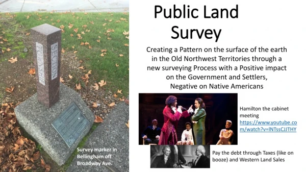
Public Land Surveying System (PLSS) • The beginning of the current day PLSS occurred with the passage of the Land Ordnance Act of 1785.
Land Ordnance Act of 1785 Purpose: To facilitate disposal (either via sale or simple giveaways) of lands west of the Appalachian Mountains that the U.S. government had acquired from the British after the end of the Revolutionary War.
Disposing of this land was a very high priority for the young U.S. Government, for several reasons: • 1. U.S. soldiers had been promised land in return for their service during the Revolutionary War, • 2. The government needed the money from the land sales (there was no tax system in place at that time), • 3. Settlers were needed in the western lands to defend the nation's frontier from ongoing Indian attacks.
The first use of the PLSS was Ohio. • This system was changed before the PLSS was applied to the great plains and other areas.
Initial Point • The first step in the PLSS, rectangular system, was the establishment of the initial point within the territory. Star sights where the most common method used.
The initial points for Oklahoma were established using star sights to establish the desired latitude and longitude. Indian Meridian: Latitude 34-29-32, Longitude 97-14-49 Cimarron meridian: Latitude 36-30-05, Longitude 103-00-07
Base line • The next step was to establish a baseline. • The baseline passes through the initial point. • It could not be a straight line because all points along the line are an equal distance from the north pole. • In some surveys the base line was adjusted for curvature every 9 miles. The base line was established to the east and to the west from the initial point, border to border across the territory being surveyed.
Prime Meridian • Meridians are geographic lines that pass through both poles and divide the earth into sections. • Many initial points were picked so they were on a principle meridian. • These are also call the prime meridian.
Standard Parallels • Standard parallels are East-West lines that are parallel to the base line. • They are numbered north and south of the base line. • Standard parallels are 24 miles apart.
Guide Meridians • Guide meridians are established at 24 mile intervals along the base line and standard parallels. • Guide meridians are not parallel to the principle meridian because they are 90o to the base line, or standard parallel and the base line is curved. • Guide meridians are not continuous. There is an offset at each standard parallel (24 miles).
Guide Meridians--cont. • Guide meridians can not be perpendicular to the base line and parallel to each other because the base line is curved.
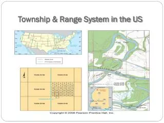
Township • A pair of standard parallels and a pair of guide meridians forms a quadrangle. • Each quadrangle is divided into 16 townships. • Townships are identified by tier and row.
Section • Each township is divided into 36 sections. • The sections are numbered in a serpentine route starting at the upper right corner of the township.
Fractions of Section • Fractions of 1/2 and 1/4 are used to describe parts of a section. • Irregular lots caused by drainage ways, or other reasons, are numbered.
A: SE1/4, S23, T4S, R6W, IM B: Determine the descriptions for each of the labeled areas.
Sometimes it helps to draw the lines on the section. • SE1/4, SW1/4, NW1/4, S23, T4S, R6W, IM • C: SE1/4, NW01/4, NW1/4 & SW1/4, NW1/4 NE1/4, S23, T46, R6 W, IM • D: S8, T46, R6 W, IM
DETERMINE THE DESCRIPTION FOR EACH AREA. A: N1/2, NW1/4, S21, T7S, R6E, IM B: SW1/4, NE1/4, S21, T7S, R6E, IM C: SE1/4, SW1/4 & SW14, SE1/4, S21, T7S, R6E, IM D: SW1/4, NW1/4, SW1/4, S21, T7S, R6E, IM