Download
1 / 49
520 likes | 968 Vues
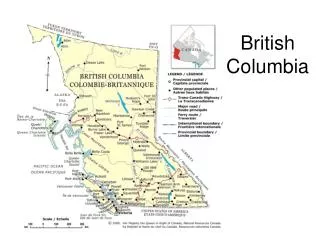
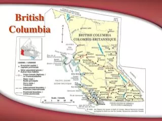
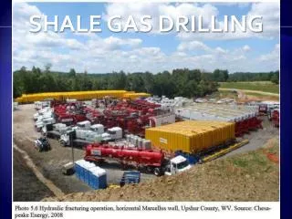
Shale Gas Activity in British Columbia . Exploration and Development of BC’s Shale Gas Areas. Christopher Adams AScT Ministry of Energy, Mines and Petroleum Resources Resource Development and Geoscience Branch 3 rd Annual Unconventional Gas Technical Forum Victoria, BC April 16, 2009.

E N D
Shale Gas Activity in British Columbia Exploration and Development of BC’s Shale Gas Areas Christopher Adams AScT Ministry of Energy, Mines and Petroleum Resources Resource Development and Geoscience Branch 3rd Annual Unconventional Gas Technical Forum Victoria, BC April 16, 2009
Presentation Outline • Overview of BC Activity and Resources – Sector Indicators • Shale Gas Horizons in BC • Shale Gas Activity and Results by Region • Policy and Incentives for Shale Gas • Summary
Oil and Gas in British Columbia Oil and gas is an economic keystone in BC BC’s Natural Gas Production (2nd highest in Canada ) • 3 Bcf/d or over 1 Tcf/y BC’s Total Oil and Gas Revenue • $4 billion (2008) up from $2.36 billion (2007) Industry Spending • $5.5 billion (2007) CAPP
Drilling Activity in British Columbia Record drilling achieved in 2005 but drilling levels down 36% in 2008
Northeast BC’s Conventional Natural Gas Reserves 2008 Raw Gas Production = 1.15 Trillion Cubic Feet (Tcf)
BC’s Undiscovered Gas Potential What will fill the gas supply gap in the future?
PNG Rights Sales in BC 2008 – highest bonus total ever at $2.66 billion and highest average price per hectare of $3,519
Distribution of PNG Rights Sales in 2008 How much was directed to potential shale gas regions?
Distribution of PNG Rights Sales in 2009 How much has been directed to shale gas so far?
Shales are the most commonly occurring type of sedimentary rock in northeast BC. Many prospective horizons occur with good total organic carbon, thermal maturity and moderate porosity In the United States, shale gas is now recognized as a viable and economic resource and currently accounts for about 10% or 6 Bcf/d of that country’s domestic gas production. In most cases, shale gas produces at relatively low rates initially, but for a longer term than conventional reservoirs. British Columbia’s shales are now being recognized as potential reservoirs and are estimated to have the potential capacity to hold between 250 to 1,000 Tcf of gas-in-place. Shale Gas in British Columbia Why is it important?
Potential Shale Gas Horizons within BC The Lower Cretaceous Wilrich and Buckinghorse shales are extensive shale horizons with generally shallow burial. Jurassic - the Nordegg shale and other members of the Fernie Group are present within the Deep Basin. Triassic - several shale units - Upper Montney now producing Evidence exists that shallow shows in the Mississippian Mattson in the Beaver River area are due to the presence of a significant shale gas reservoir Several thick Devonian shale units have been the focus of most industry activity to date - widespread (80,000 km2)
Liard Basin & Fold Belt Location and Setting The region is a relatively unexplored area situated immediately east of the Cordilleran Fold and Thrust belt. The region covers an area of approximately 1.25 million hectares and contains sedimentary strata of Cambrian to Upper Cretaceous age. Some of the potential hydrocarbon objectives include: Devonian Dunedin/Nahanni Formation, Mississippian Banff, Debolt, and Mattson formations and the Cretaceous Chinkeh.
Liard Basin Land Sales PNG Rights Sold
Liard Basin & Fold Belt Activity Questerre Energy Corporation and Transeuro Energy Corp. have been conducting joint operations at Beaver River (160 kilometres northwest of Fort Nelson). Evaluation of Mississippian age shales of the Mattson/Besa River as a potential resource play. Re-entry and perforating operations were conducted in three old wells (A-2, A-6 and B-2).
Liard Basin & Fold Belt Activity Questerre and Transeuro continued with their development program in in 2008. Compression was added to A-2 well. A-5 well tied into local gathering system - producing from a carbonate-rich sequence in the deeper shale zones. A-5 well was the third well to be put on production from shale/siltstone intervals at Beaver River. Questerre to evaluate two additional re-completion candidates to further pilot test this new shale play.
Horn River Basin A Key Shale Gas Area in the Northeast BC Covers an area of approx. 1.3 million hectares (139 townships) north of Fort Nelson. Approximately 300 wells have been drilled in the Basin since the late 1950s. Several units now being tested in Lower Carboniferous and Upper Devonian strata.
Horn River Basin Prospect Area The Horn River Basin lies to the east of the Kledo-Bovie Lake Fault System and extends further east to the Jean Marie Shelf Edge The Horn River Basin’s eastern edge is the Slave Point carbonate platform The Basin’s western side sees a dramatic fault system separating the Horn River from the Liard Basin. Production west of the Bovie fault was developed in Cretaceous sandstones of the Maxhamish area.
Horn River Basin Prospect Area cont’d Experimental shale gas projects are testing potential reservoirs in the Upper Devonian/Lower Mississippian Exshaw shale source rock and the Muskwa/Otter park members of the Middle Devonian Horn River. The Exshaw Formation and the Upper Devonian Muskwa Formation are thin, but widely distributed organic shales. The Upper Devonian Fort Simpson Formation and the Mississippian/Devonian Besa River Formation are thick basin-filling shale units. Sandstone and siltstone beds are present throughout the Fort Simpson.
Horn River Basin Resource Potential The organic rich Lower Carboniferous and Upper Devonian strata of the Horn River and Cordova shale basins make up a significant proportion of Canada’s potential shale gas reserves. Some major producers have reported significant gas-in-place estimates or reserves on their respective properties: EnCana Corporation, with the largest land position in the HRB, has estimated 35 Tcf of gas-in-place - predicts that it can produce as much as one billion cubic feet per day from its holdings. EOG Resources Inc. has stated that its Ootla area holdings could yield as much as 6 Tcf of net natural gas reserves.
Horn River Basin PNG Rights Sold
Horn River Basin Experimental Schemes Interest by several companies in the shale gas potential of British Columbia continues to mount. Since 2002, the BC Oil and Gas Commission (OGC) has approved 20 areas for shale gas experimental schemes (including six amendments) in the Horn River Basin. The OGC issues approvals for experimental status under section 100 of the Petroleum and Natural Gas Act. Operators receiving such approvals must submit a progress report to the OGC annually
Horn River Basin Experimental activity in the scheme areas has been high since 2001
Horn River Basin Who are the operators?
Horn River Basin Horn River Basin Producers Group – A Collaborative Effort? EnCana Corporation Apache Canada Devon Canada Corporation, EOG Resources Inc. Nexen Inc. Quicksilver Resources Inc. Stone Mountain Resources Ltd. Imperial Oil Limited-ExxonMobil Canada Limited (partnership) ConocoPhillips Petro-Canada Petrobank Energy and Resources Ltd.
Horn River Activity EnCana Corporation is leading the way with deep horizontals and multiple fracture stimulations. Reporting initial production test rates of over 5 mmcf/d of gas from its test wells. EnCana recently recompleted a vertical well in the Ootla area, which tested gas at 460 mcf/d. EnCana recently constructed a 15-kilometre,168 millimetre diameter natural gas pipeline, which runs from its experimental shale gas well in the Etsho area (b-90-J/94-O-8) to a connection point at Missle (d-54-A/94-O-9)
Horn River Activity Apache Canada Ltd. feels its Muskwa play in the Horn River Basin is key to its production growth. The producer successfully drilled three wells in the Ootla area where it believes the resource potential could be in the range of 9 to 16 Tcf. Planning to drill 25 wells in the Ootla area in 2009. Apache states it will have to make significant investments in infrastructure to produce the gas, which may produce significant volumes by 2011 or 2012.
Horn River Activity In late 2008, EOG Resources Inc. completed three full-length lateral shale gas wells that tested gas at rates of between 9 and 16 mmcf/d. These wells were likely deep experimental tests in the Maxhamish area, which were granted experimental scheme status in September of 2006.
Horn River Activity Nexen Inc. announced positive results from its 2007/2008 winter shale gas program in the Horn River Basin. Nexen Inc. plans to drill seven wells from a single pad in 2009 and do fracture stimulation work in the summer. Nexen has roughly $160 million earmarked for shale gas activity this year.
Horn River Activity Devon Canada Corporation drilled three pilot wells on its 62,000 net hectares in the Horn River Basin in 2007/2008. Of this year's Canadian capital budget, about $100 to $150 million is earmarked for the Horn River program. Currently drilling its third horizontal well and will soon drill three stratigraphic wells. Devon is also participating in a proposed gas plant and associated pipeline infrastructure project in the area.
Horn River Activity Quicksilver Resources Inc. acquired 19 licenses covering over 51,000 net contiguous hectares at the November 2007 and March 2008 BC PNG rights sales. Recently announced it has reached total depth on its first of two horizontal wells in its Horn River exploration program. Testing for Devonian Muskwa and Klua shales.
Horn River Basin Plans for Transportation Infrastructure • EnCana Corporation • 2.4 bcf per day gas-processing plant • Spectra Energy Corp. • staged expansion of it gas gathering and processing capacity • TransCanada Corporation • support for firm transportation contracts of 378 mmcf per day
Cordova Embayment Area & Geology An area covering approximately 379,000 hectares within the northeast section of the Fort Nelson/Northern Plains region. Area lies to the east of areas that have well-established Devonian Jean Marie gas production as well as deeper exploration targets such as Slave Point and Pine Point (Keg River) carbonates. Over 325 wells have been drilled in the basin since the late 1950s with only a handful targeting shale gas. Because of geological similarity with the Horn River Basin, the Cordova Embayment appears to be a logical place to continue exploration for shale plays.
Cordova Embayment PNG Rights Sold
Cordova Embayment Experimental Schemes • Two experimental schemes approved in 2008: • Nexen Inc. in the Helmet area • 2. Penn West Energy Trust in the Helmet area
The Montney Play Region Another Key Shale Gas Region The Triassic Doig and Montney formations are two zones in British Columbia that have potential for shale gas production. The Triassic Doig and Montney formations extend over 7 million hectares in northeast BC. Depth is in 400 to 4,400 metre range and up to 500 metres thick. The main Montney play trend covers approximately 1 million hectares (2.5 million acres) in the South Peace region Proven production (Upper Montney) in the Dawson Creek/Fort St John area
Montney Play Region Geology & Potential Major facies include fine-grained shoreface, shelf siltstone to shale, fine-grained sandstone turbidites, and organic rich phosphatic shale. The Triassic Upper Montney has seen exceptional growth. Producing areas include Swan, Dawson, Saturn and Monias. From Petroleum Geology Open File 2006-2 Regional “Shale” Gas Potential of the Triassic Montney and Doig Formations: Upper Montney - OGIP 30 to 200 Tcf. Lower Montney - OGIP 50 to 500 Tcf Doig - OGIP 40 to 200 Tcf Doig Phosphate unit - OGIP ~70 Tcf
Montney Play Region PNG Rights Sold
Montney Play Region Activity ARC Energy Trust is the dominant producer of Upper Montney shale gas in the Dawson Creek area. Entered the play six years ago. Using horizontal drilling technology with new and improved completion techniques. In 2008, ARC drilled two wells and completed nine wells at Dawson. Twelve wells waiting to be tied-in at year-end. 2008 4th quarter production from the Dawson field was as high as 50 mmcf per day . Total discovered gas in place for the Upper Montney at 8.1 Tcf in latest analysis.
Montney Play Region Activity EnCana Corporation has significantly ramped up its operations in the Swan Lake area of the Montney play trend. The producer can now complete as many as eight staged fracture stimulations along the horizontal leg of a well in just four days. With current mapping of the Upper Montney, EnCana has identified 3.7 Tcf of original gas-in-place (OGIP) and 5.6 Tcf. for the Lower Montney.
Montney Play Region Activity Murphy Oil Corporation continues to develop Triassic shale gas potential from the Montney turbidites in the Tupper Creek area. To develop Tupper, Murphy uses horizontal wells, and to delineate the resource it uses vertical wells. Gas production from Tupper started in December 2008 and is currently flowing at about 30 mmcf per day (9 wells, 2 pads). Murphy plans to drill 118 horizontal wells over the next six years. Received National Energy Board approval for a proposed 29-kilometre, 12-inch sweet gas pipeline starting near its Tupper play at ending in Alberta.
Montney Play Region Activity The Parkland area is now a core operating area for Storm Exploration Ltd. In 2008, activity at Storm’s Parkland property included the drilling of 11 horizontal Montney development wells and 10 vertical wells targeting the Montney . Development of the Montney discovery continues to progress. Storm is currently producing 27 mmcf per day of raw gas from 11 horizontal Montney wells plus three mmcf per day of raw gas from 10 Montney vertical wells. Potential gas in place from the Montney at Parkland ranges from 330 to 430 Bcf.
Montney Play Region Activity Duvernay Oil Corp. (recently acquired by Shell Canada Limited) expanded its Montney program in the Sunset Prairie-Groundbirch area complex. In the second quarter of 2008, Duvernay had five rigs active in the complex; five horizontals after spring break-up 2008. One of those five horizontals tested at initial rates of 6.4 mmcf per day. Duvernay has 120 net sections of Montney rights in the prime Montney gas fairway It has built an extensive gas infrastructure in the Sunset Prairie-Groundbirch area.
Montney Play Region Activity Talisman Energy Inc. is building a considerable land position in the Montney fairway in NEBC. Active in several regions within the Montney. Talisman holds 35,200 net hectares of land in the Groundbirch area, where it will continue with its pilot program this year. Talisman is in the Farrell Creek area where it successfully tested a vertical well with up to 5 mmcf per day of raw gas. 14 pilot wells are planned in the Montney shale in NEBC in 2009.
Montney Play Region Activity Canadian Spirit Resources Inc. is currently evaluating the productive capability of both its shallow Gething play and its deeper Montney play. At the March 25th BC PNG rights sale, Canadian Spirit reported success in acquiring eight sections of Montney formation and other deep rights At Farrell Creek, Canadian Spirit now holds approximately 50 sections of Gething and other shallow rights and approximately 46 sections of Montney and other deep rights.
Cretaceous Shale Prospects Shale gas activity directed towards Cretaceous horizons is being assessed in several areas of the Fort St. John and Northern Foothills regions. The Blair Creek and Farrell Creek areas in the Northern Foothills region have seen a steady increase in the sale of petroleum and natural gas rights over the last four years. Lower Cretaceous sequences are the exploration focus in the Beg/Jedney areas and further south in the Blair Creek and Farrell Creek areas. Each of these areas has unique characteristics in terms of its shale gas potential. Companies currently operating in these areas are evaluating fracture stimulation programs and continue to optimize completion methods that could potentially increase well productivity.
How is the BC Government actively facilitating investment for shale gas? • Oil and Gas Development Strategy • Royalties lowered • Regulations reduced • Improved road access • High quality geoscience information • Full access to drill core and cuttings for all wells • Service Sector Strategy (service provider of choice)
Summary Opportunities abound in shale gas play evaluation and development.The potential for this new source of gas supply is becoming increasingly significant.Shales are thick, with high total organic carbon (TOC) and widespread in northeast British Columbia with much open tenure available.Refinement of drilling and completion processes to where tangible results are identified. The level of cooperation among producers and regional land-use planning is unique, particularly in the Horn River.
Upcoming Geoscience Releases focussing on Shale Gas Activity • SHALE GAS IN NORTHEAST BC: INDUSTRY ACTIVITY MAPS 2009 Available now! • On EMPR web site • Play activity maps, including land sale/drilling summaries for major shale gas plays • SUMMARY OF SHALE GAS ACTIVITY IN NORTHEAST BRITISH COLUMBIA 2008 Available soon! • Petroleum Geology Open File • A compilation of BC’s shale gas activity for 2008 • Land sale activity in the Horn River Basin, Cordova Embayment and Upper Montney play region • Summary of active shale gas experimental schemes • Activity by geographic areas and geology • BRITISH COLUMBIA OIL AND GAS EXPLORATION ACTIVITY REPORT 2007-2008 Available soon! • Information Circular • highlights of 2007-2008 oil and gas industry exploration activity in the six resource regions of northeast British Columbia: Laird Basin & Fold Belt; Fort Nelson/Northern Plains; Fort St. John; Northern Foothills; Southern Foothills; and the Deep Basin. • Visit us on line at www.empr.gov.bc.ca
Thank You! Christopher Adams AScT Ministry of Energy, Mines and Petroleum Resources Resource Development and Geoscience Branch 3rd Annual Unconventional Gas Technical Forum Victoria, BC April 16, 2009