Urban Models Of Development
270 likes | 556 Vues
Urban Models Of Development. Unit 1: Module 1. What is a model?. A model is a concept that is used to help us understand real world systems. They may be applicable to some places only and not the entire world. They come in different shapes, sizes and styles

Urban Models Of Development
E N D
Presentation Transcript
Urban Models Of Development Unit 1: Module 1
What is a model? • A model is a concept that is used to help us understand real world systems. • They may be applicable to some places only and not the entire world. • They come in different shapes, sizes and styles • Usually they can be represented by a diagram that shows connections or patterns such a flowchart.
Main Urban models • Urbanisation is a process that is rapidly occurring in many parts of the world, so it is important to us to understand how it is occurring to be able to • Direct/ control the urban development • Manage the resources that people will need • Preserve certain economies • Develop a plan for sustainable living
Definition for Urbanisation • The process of change from rural society in which people are scattered across the landscape to an urban society where people are concentrated into thickly populated nodes.
Defining an urban/rural settlement Criteria used: • Size of population • Economic Activity • Facilities and functions (i.e. utilities) • Communication lines • Government legislation
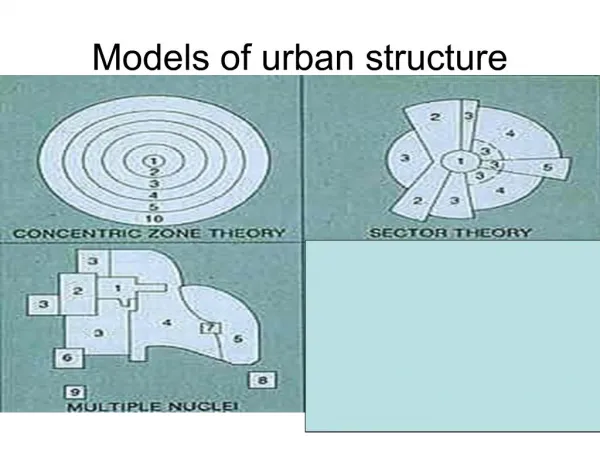
Main Theories • Central Place Theory- Walter Christaller • Burgess Concentric Zone Model • Hoyt’s Sector Model • Harris and Ullman model • Bid Rent Theory
Central Place Theory • Central place theory is a spatial theory in urban geography that attempts to explain the reasons behind the distribution patterns, size, and number of cities and towns around the world.
Who developed Central Place Theory? The theory was first developed by the German geographer Walter Christaller in 1933 after he began to recognize the economic relationships between cities and their hinterlands (areas farther away).
The main question Christaller asked himself that sparked his development of this theory Are there laws (rules/ or relationships) which determine the number, size and distribution of towns?
To answer the question, Christaller made some basic assumptions: • Land is uniform (even) so there is equal easy of transport in all direction and only 1 (ONE) form of transport. • Everyone has the same • Income • Tastes • Demands for goods and services
3. All goods and services • regardless of where they are offered are the same cost • Some goods and services are demanded more than others 4. People get their goods and services from the nearest place where they are available, to minimise the transport costs and time taken. 5. All goods and services are provided in a central place (location) 6. People providing them try to maximise profits by locating as far away from other providers of the same good and service.
Burgess Concentric zone model • Walk through most contemporary cities and the mazes of concrete and steel can be some of the most intimidating and confusing places to visit. Buildings rise up tens of stories from the street and spread for miles out of view but patterns can still be found and modeled.
In the 1920's sociologist Ernest Burgess wanted to model was Chicago's spatial structure with regards to the usage of "zones" around the city.
These zones radiated from Chicago's center, The Loop, and moved concentrically outward.
What did Burgess Assume? • Within the city people compete for space • Only those who could afford it got the best locations for their homes and businesses • The poorest groups had the least number of choices and were left with the worst locations • This formed distinct functional zones which is centred around the CBD • Each zone is different in terms of age and character.
Hoyt’s Sector Model • Hommer Hoyt developed his sector model as an extension of Burgess’model. • He accepted that the zones formed around the centre (CBD) but suggested that the zones expanded outward from the centre along railway lines and other lines of communication
Harris and Ullman: Multiple Nucleii • Developed in 1945 by two geographers, Chauncy Harris and Edward Ullman, to try and further describe a city's layout.
Multiple Nucleii Model • Challenged the idea that there was a single, dominant CBD. • Instead there are a number of CBDs from which a town can grow outward from. i.e. the idea of multiple nucleii. 3. Larger cities therefore would have more nucleii than small towns.
The Land Value Model or Bid Rent Theory Out of Von Thuunen’s agricultural theory emerged the bid-rent theory. The bid rent theory is a geographical economic theory that refers to how the price and demand for real estate changes as the distance from the Central Business District (CBD) increases
Main idea of Bid Rent • Land values vary from place to place within the Urban area. (b) Values are highest towards the city centre and decline away from it. (c) There are also secondary high value areas existing in the city.
2. Urban land uses differ in terms of: • Type of location • The amount of rent they can afford Therefore each urban land use has a different bid-rent curve (based on the amount of rent it can afford to pay).