Download
1 / 23
230 likes | 255 Vues
Discover the diverse models used to study urban structures worldwide, including the growth stages of Dublin and functional zones in cities, illustrated through historical perspectives and current examples in London and Miami.

E N D
Comparative Models of Urban Systems How are cities organized?
What type of city is London? • There were a hundred thousand shapes and substances of incompleteness, wildly mingled out of their places, upside down, burrowing in the earth, aspiring in the earth, moldering in the water, and unintelligible as in any dream. - Charles Dickens on London in 1848 • London today: Canary Wharf, Croydon • Miami/Fort Lauderdale :Kendall • Boca Raton, Wilton Manors, • Deerfield Beach, Pembroke Pines • Hallandale Beach
Purpose of Urban Models • To understand why cities are spatially organized in various ways, geographers have developed models that explain and predict the internal structures of cities. • Most focus on patterns of internal growth in U.S. cities.
The Growth of Dublin • Like all cities throughout the world, Dublin has grown over a long period of time. We will now examine some different stages in Dublin’s growth.
The Growth of Dublin Viking Dublin Dublin began as a Viking settlement. Like many other Viking settlements, Dublin was an ideal place at the mouth of a river. From here the Vikings could trade. The Anglo-Normans The Normans occupied Dublin in 1169. They built stone walls around the city. Dublin became a Medieval city with narrow streets. Poor sanitation caused many deaths. The 16th-18th Centuries Dublin was extended and many new streets were added in a grid-iron pattern. Parks like St. Stephen’s Green were made and Georgian Houses were built.
The Growth of Dublin The 19th Century After 1800 many of the wealthy people who lived in the Georgian houses left Dublin. Landlords bought these tenements and rented rooms to families. There was huge overcrowding in these tenement buildings and poverty and disease were widespread. The Dublin docklands became an important source of work. Dublin became a distribution centre. Goods were distributed throughout Ireland along the canal and railway lines. The 20th Century Dublin grew rapidly in the 20th century. The inner city slums were cleared and people moved out to new suburbs like Ballyfermot, Crumlin, and Finglas. Newer suburbs were then developed around the villages of Clondalkin, Lucan and Tallaght.
Employer No. of Employees • MIAMI-DADE COUNTY PUBLIC SCHOOLS 48,571 <3 • MIAMI-DADE COUNTY 29,000 • UNITED STATES GOVERNMENT 19,500 • FLORIDA GOVERNMENT 17,100 • UNIVERSITY OF MIAMI 16,100 • BAPTIST HEALTH SOUTH FLORA 13,376 • JACKSON HEALTH 12,576 • PUBLIX 10,800 • AMERICAN AIRLINES 9,000 • FLORIDA INTERNATIONAL UNIVERSITY 8,000 • MIAMI DADE COLLEGE 6,200 • PRECISION RESPONSE CORPORATION 5,000CITY OF MIAMI 4,309 • FLORIDA POWER AND LIGHT COMPANY 3,840 • CARNIVAL CRUISE LINES 3,500
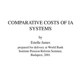
Functional Zones in Cities • Each model of the city, regardless of the region, is a study in • functional zonation—the division of the city into certain regions (zones) for certain purposes (functions). • Zones of the city exist and play certain roles in the city's life, whether to house residents, produce goods, educate students, or accommodate government. Each zone or region is part of the larger city.
The following zones can be seen in most cities: • 1. A Central Business District (CBD) • 2. Some smaller shopping areas • 3. A number of shopping centres • 4. Industrial areas • 5. Open space for recreation / leisure
Central Business District • Land use models possess a CBD. • Central Business District: Original core of the economy, like the nucleus of a cell. • The degree of influence and geographic location of the CBD varies model to model.
Developed by Ernest Burgess • Developed in the 1920s the concentric zone model was the first model to explain and predict urban growth. • Based on growth in Chicago • Zones: • 1. CBD • 2. Light manufacturing • 3. Blue Collar Workers • 4. Middle Class • 5. Suburban Ring • Dynamic: city grows; inner rings affect outer ones
Invasion and Succession • Burgess’ Concentric Zone model assumes a process called invasion and succession (succession migration) • A series of migration waves, with one group moving in and establishing itself. • New arrivals to cities tend to move first into the inner rings, near the CBD. • Eventually people and economic activities in the center are pushed out into farther rings
Homer Hoyt (1939); criticized Burgess Model as too simple & inaccurate • Urban land use and growth are based on transportation routes and linear features like roads, canals, railroads, and major boulevards. • Not just concentric zones around the CBD. • Still has strong CBD • According to this model- • Many factories and industrial activities follow rail lines. • Lower socioeconomic housing follows lines of public transportation. • Sectors that service visitors are located along major highways. • ITS ALL ABOUT TRANSPORTATION
Land gets less valuable as you move out from the CBD. Buildings get smaller as you move out from the CBD.
Multiple Nuclei Model • Chauncy Harris & Edward Ullman (1945); neither of previous two models are accurate • CBD not as significant • Suggest growth occurred independently around several major focal points. • Separate nuclei become specialized and differentiated, not located in relation to any distance attribute
Developed to explain suburban regions that were functionally tied to mixed-use suburban downtowns with relative independence from the CBD. • Suburban downtowns have become independent functioning “urban realms” • All the amenities needed for living are now located in the suburban downtown.
Primate cities in developing countries are called megacities when the city has a large population, a vast territorial extent, rapid in‐migration, and a strained, inadequate infrastructure. For example, Mumbai, India, has more people than the country of Australia. São Paulo, Brazil, covers more land than the country of Belgium. Kinshasa, The Congo, is the fastest growing city in Africa. Jakarta, Indonesia, is the largest city in the world without a subway or metro system.