Download
1 / 11
140 likes | 467 Vues
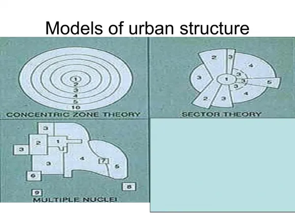
Comparative Models of Urban Systems. Purpose of Urban Models. To understand why cities are spatially organized in various ways , geographers have developed models that explain and predict the internal structures of cities . Most focus on patterns of internal growth in U.S. cities.

E N D
Purpose of Urban Models • To understand why cities are spatially organized in various ways, geographers have developed models that explain and predict the internal structures of cities. • Most focus on patterns of internal growth in U.S. cities.
Central Business District • Land use models possess a CBD. • Central Business District: Original core of the economy, like the nucleus of a cell. • The degree of influence and geographic location of the CBD varies model to model.
Developed in the 1920s the concentric zone model was the first model to explain and predict urban growth. • Based on growth in Chicago • Developed by Ernest Burgess • Zones: • 1. CBD • 2. Light manufacturing • 3. Blue Collar Workers • 4. Middle Class • 5. Suburban Ring • Dynamic: city grows; inner rings affect outer ones
Invasion and Succession • The Concentric Zone model assumes a process called invasion and succession (succession migration) • A series of migration waves, with one group moving in and establishing itself. • New arrivals to cities tend to move first into the inner rings, near the CBD. • Eventually people and economic activities in the center are pushed out into farther rings
Homer Hoyt (1939); criticized Burgess Model as too simple & inaccurate • Urban land use and growth are based on transportation routes and linear features like roads, canals, railroads, and major boulevards. • Not just concentric zones around the CBD. • Still has strong CBD • According to this model- • Many factories and industrial activities follow rail lines. • Lower socioeconomic housing follows lines of public transportation. • Sectors that service visitors are located along major highways. • ITS ALL ABOUT TRANSPORTATION
Multiple Nuclei Model • Chauncy Harris & Edward Ullman (1945); neither of previous two models are accurate • CBD not as significant • Suggest growth occurred independently around several major focal points. • Separate nuclei become specialized and differentiated, not located in relation to any distance attribute
Developed to explain suburban regions that were functionally tied to mixed-use suburban downtowns with relative independence from the CBD. • Suburban downtowns have become independent functioning “urban realms” • All the amenities needed for living are now located in the suburban downtown.
Edge Cities • Self-Sufficient urban areas within a greater metropolitan complex. • Often develops on highway exits. • The development of edge cities paired with the growth of highways leads to explosive industrial growth referred to as urban sprawl. • Urban sprawl….the diffusion of urban land use and lifestyle into formerly nonurban, often agricultural lands.
Writing Prompt • In your journals respond to the following. • Can you see evidence of urban sprawl in Arizona? • How does urban sprawl impact the existence/importance of the Central Business District?