URBAN Geography - Intro
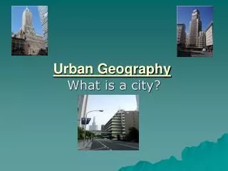
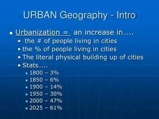
URBAN Geography - Intro. Urbanization = an increase in….. the # of people living in cities the % of people living in cities The literal physical building up of cities Stats….. 1800 – 3% 1850 – 6% 1900 – 14% 1950 – 30% 2000 – 47% 2025 – 61%. Urbanization – Intro – cont’d.

URBAN Geography - Intro
E N D
Presentation Transcript
URBAN Geography - Intro • Urbanization = an increase in….. • the # of people living in cities • the % of people living in cities • The literal physical building up of cities • Stats….. • 1800 – 3% • 1850 – 6% • 1900 – 14% • 1950 – 30% • 2000 – 47% • 2025 – 61%
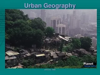
Urbanization – Intro – cont’d • Urbanization is a measure of development (abundant AG tech, people leave rural areas for cities for work and services) • MDCs - @75% urban • LDCs - @40 % urban • BUT LDCs contain most of world’s largest cities (6 of top 10 in LDCs) • i.e. MDCs have highest levels of urbanization, LDCs have highest rates
Urbanization – Intro – cont’d • LDCs = mega cities: rapid pop growth and migration to cities has caused explosion of urban growth in LDCs. LDCs cannot support booming growth. • Mega cities plagued by chaotic, unplanned growth…no jobs, poor infrastructure, inadequate housing, urban squalor, horrible pollution, poverty, squatter settlements
Urbanization – Intro – cont’d • MDCs = world cities – worldwide centers of econ, pol, cultural activity and influence. • Top tier = econ and cultural powerhouses…NYC, London, Tokyo • Second tier…. • Govn’t Seats – DC, Moscow, Paris • Pop Culture – LA, Mumbai • Industrial Centers – MX City, Sao Paulo
Defining Urban Settlements • Where does “the city” begin?? • Social distinctions betwn urban/rural…..Cities have • Lots of people most of whom are anonymous • High pop density • Job specialization • Social heterogeneity (diverse)
Physical Distinction Betwn Urban and Rural • City Center: legal boundary (i.e. DC proper). Independent and self governing unit (city officials, taxes, providing services, etc.) • Urbanized Area: central city + surrounding suburbs (i.e. Arlington, Herndon = urbanized area of DC)
Physical Distinction Betwn Urban and Rural • Metropolitan Statistical Area (MSA): the functional area/region of a city – i.e.. its zone of influence • Megalopolis: When MSAs overlap and create one continuous highly urbanized complex. Ex: from Boston to DC = Boswash Corridor
Central Business District CBD • CBD = city center/historic downtown within the central city • CBD is compact – less than 1% of urban area but has large %% of shops, offices, public institutions, sports complexes, etc. • Historically services were in CDB but today have moved to suburbs
CBD • Land value in CBD is extremely high • Demand for space leads to sky scrapers…since cannot build out you build up – unique skylines • Little manufacturing in CBD (not enough land) • Few people actually live in CBD (rent too high)
Spatial Organization of Urban Areas • People and activities in cities are not distributed randomly – they concentrate in particular places depending on their social characteristics • 3 prominent models explain city organization…..
Concentric Zone Model • Dev in 1923 by E.W. Burgess • Based on Chicago • Concentric rings of dev coming outward from the core (CBD) • Each ring = diff types of dev and econ activities • Land value decreases as you move out • Model based on process of invasion and succession – newest immigrants move into old housing near city center and push earlier groups outward
Concentric Zone Model • Zones… • 1.) CBD – non residential activities • 2.) Transition Zone – industry and poor quality housing (newest immigrants) • Industrial Workers’ houses – working class • Middle Class/better homes • Commuter Zone – high class residencies
Sector Model • Dev in 1933 by Homer Hoyt • Also based on Chicago • Says city dev in sectors not rings. Sectors radiate out from CBD like spokes on a wheel • Activities expand in wedges • Seems to work better for Latin American cities (MX City fits sector model)
Multiple Nuclei Model • 1945 – Harris and Ullman • City doesn’t have just one central core but many nodes of business and cultural activity • Los Angeles = classic example – no real downtown but instead many independent nodes of high land value and business activity – Santa Monica, Pasadena, Hollywood, etc.
Multiple Nuclei Model • This is a better model for cities built mostly after WW II and post auto dependent. Older cites built b/f auto are more compact w/ real downtown (CBD). Newer cities have more sprawl and multiple nuclei. • *** NO city matches any one model perfectly
City Models • To use models for data mush have good data – Census Tracts – cities divided into about 5,000 resident census tract sections (often follow neighborhood lines). Every 10 yrs gather info about people in that tract (race, age, median income, occupation, level of education, etc.)
Criticisms of Models • 1.) Models too simplistic and fail to consider all of the varied and complicated reasons that cause people to select a certain location • 2.) all 3 models created in U.S. between world wars – are they relevant to other countries and are they still relevant today?
Inner City Problems • In U.S. cities greatest contrast is betwn suburbs and inner city • Ghettoization: process of inner city decay • Problems……..
Inner City Problems • Old, poor quality housing • Filtering – subdividing big old homes into several apartments and use for low income rent • Redlining: banks draw lines on map and refuse to loan $$ within • Public housing projects (subsidized – pay 30% of income in rent) –run by govnt…poorly maintained, drugs, crime, violence, gangs, high density, culture of poverty, etc. • Scattered public housing – pros/cons?
Inner City Problems • Chicago housing projects…. • government subsidized housing
Inner City Problems • 2.) Social Problems • Permanent underclass – trapped in perpetual cycle (unemployment, teen pregnancy, drugs, gangs, single parents, welfare, high school dropout, etc. Can you get out? (There Are No Children Here) • Racial and ethnic segregation – disproportionate minority representation
Inner City Problems – cont’d • 3.) Economic Problems • Often lacks adequate public services and lacks tax base to pay for them (i.e. schools, roads, etc.) • Annexation – legally adding land area to a city’s boundaries. Most suburbs do not want to be annexed in and rarely happens anymore
Inner Cities – Urban Renewal • Revitalization – new attempts to fix up downtown…buy poor houses, build new, shopping, cultural attractions…try to b ring in young, single professionals • Gentrification: process where inner city neighborhoods turn into expensive/fashionable urban districts (squeezes out low income residents)
Problems of Suburbs • Rapid growth of Suburbs in 2nd half of 20th C (i.e. auto, GI Bill, mass production of housing) • 1950: 20% in suburbs 40% in central city 40% small towns/rural areas 2000: 50% in suburbs 30% in central city 20% small towns/rural areas
Suburbs – cont’d • Counter urbanization – net migration from urban to rural areas (happening in some parts of N. American and W. Eur for first time). More people moving to rural areas than are leaving. • Exurbanite: people who leave city to move to suburbs or rural area
Suburbs – cont’d • Urban Sprawl: goes hand and hand w/ transportation…HUGE sprawl after the automobile • Older cities like NYC, pre-auto – densely packed, narrow streets, lots of high rise • Newer cities like LA, Atlanta – post auto are sprawling areas with clogged superhighways, multiple nuclei, and far flung suburbs that operate independently of each other
Suburbs – cont’d • Suburbanization – is a process NOT a place • Began after WW II, mass phenomenon by end of 20th C • GI Bill, mass auto ownership, and mass production of housing drives suburbanization
Suburbs – cont’d • Cons of Suburbs…. • Land hungry process – vanishing green, encroaching on good AG land • Lose unique sense of place – all are cookie cutter alike (strip malls, chain stores) • Auto dependent and fuel consumption (pollution) • Rush hour commute
Suburbs – cont’d • Suburban growth comes at expense of inner city • Erosion of tax base • Segregation – poor, elderly, singles, minorities in cities. Young families, white, educated wealthier move to suburbs. (Suburbs replace vertical seg) • Spatial Segregation – rarely go to other’s place • Zoning also fuels segregation
Suburbs – cont’d • Edge Cities: urban sprawl sometimes takes the form of edge cities • Located on outskirts of larger cities and come to serve many of same functions as large city • Often located off a beltway surrounding main city • Classic ex: Tyson’s Corner
Smart Growth/Urban Growth Boundaries • Limit sprawl through long range planning and efficient transportation • Promote compact and contiguous dev (i.e. fill in the gaps) • Protect farmland, recreation, wildlife • Set growth boundaries • In U.S. – MD, OR, NJ, RI, and WA lead the way w/ smart growth
Central Place Theory • Theory developed by Walter Christaller in 1930s in Germany. Looks at relationship betwn cities and surrounding communities based on people’s demands for goods and services • Central Place: place (big city) people travel to make purchases • Market Area: areas people travel from for purchases (i.e. the functional region of the central place)….where do you go to buy groceries, a car, medical treatment, etc.?
Central Place Theory • Large cities are the econ hubs for their region b/c they provide a great variety of goods and services not available in smaller communities • Hinterlands: smaller towns in periphery of big city/central place. People from hinterland often travel to central place for big city amenities (i.e. sports teams, cultural events, restaurants, etc.). Small towns in hinterland contain fewer goods and services than central place.
Central Place Theory • Size of Market Area….assume you wanted to open a new store, how do you determine 1.) if it will be profitable and 2.) where the best location is within the market?? The answer to these questions varies for all services based on range and threshold.
Central Place Theory • Range: maximum distance people willing to travel for your service • Often expressed in time not distance • Short distances for groceries, long for bball game. Short distance for gas, long distance for medical treatment • Must be modified if competing locations provide same service
Central Place Theory • Threshold: minimum number of people needed to support a service • How many customers do you need to make a profit? • Potential customers in a given areas depend on the product (i.e. not a high demand for a roller skate rink in a retirement community)
Central Place Theory • Low order central place functions: have small range and threshold. • Services obtained on regular basis • Requires only a small market to be profitable • People unwilling to travel far to obtain it • Ex: gas, groceries, movies, etc.